
FCCInfo.com
A Service of Cavell, Mertz & Associates, Inc.
(855) FCC-INFO
|
|
WMCQ from 02/06/2003 WMCQ from 01/23/2003 WMCQ from 12/24/1996 |
|  |
|
|||||||||||||||
|
|
WMCQ Channel: 219A 91.7 MHz Muskegon, Michigan Service: FM - A full-service FM station or application. Facility ID: 84851 Fac. Service: FM Status: License Application Accepted: 04/01/2005 Application Granted: 05/03/2005 File Number: BLED-20050401AOE License Expires: 00/00/0000 Prefix Type: This is a license for a noncommercial educational FM station Application Type: License To Cover FCC Website Links: LMS Facility Details This Application CDBS Application Other WMCQ Applications Other WMCQ Applications in CDBS Including Superseded Applications Mailing Address Correspondence for WMCQ Correspondence related to application BLED-20050401AOE Service Contour - Open Street Map or USGS Map (60 dBu) Service Contour - KML / Google Earth (60 dBu) Public Inspection Files Facility Type: NON-COMMERCIAL EDUC. FM Class: A, A Zone I; I-A; or II station; with 0.1kW-6kW ERP and a class contour distance <=28km Site Location: 43-18-37.1 N 85-54-44.2 W (NAD 83) Site Location: 43-18-37.0 N 85-54-44.0 W (Converted to NAD 27) Effective Radiated Power: 6 kW Transmitter Output Power: 2.02 kW Antenna Center HAAT: 100 m (328 ft.) Antenna Center AMSL: 328.5 m (1078 ft.) Antenna Center HAG: 88 m (289 ft.) Site Elevation: 240.5 m. (789 ft.) Height Overall*: 233.5 m (766 ft.) (* As Filed In This Application, may differ from ASR Data, Below.) Directional Antenna Antenna Make/Model: Shivley 6810-4RDA, four sections Antenna ID: 69387 Polarization: | ||||||||||||||||||
| Antenna Data for Antenna Id: 69387 WMCQ FM File: BLED-20050401AOE Shivley - 6810-4RDA, four sections Service: FM | 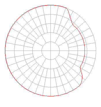 | ||||||||||||||||||
| Azimuth | Ratio | Azimuth | Ratio | Azimuth | Ratio | Azimuth | Ratio | ||||||||||||
| 0 | 1.000 | 10 | 1.000 | 20 | 1.000 | 30 | 0.859 | ||||||||||||
| 40 | 0.755 | 50 | 0.755 | 60 | 0.755 | 70 | 0.755 | ||||||||||||
| 80 | 0.755 | 90 | 0.755 | 100 | 0.755 | 110 | 0.752 | ||||||||||||
| 120 | 0.755 | 130 | 0.909 | 140 | 1.000 | 150 | 1.000 | ||||||||||||
| 160 | 1.000 | 170 | 1.000 | 180 | 1.000 | 190 | 1.000 | ||||||||||||
| 200 | 1.000 | 210 | 1.000 | 220 | 1.000 | 230 | 1.000 | ||||||||||||
| 240 | 1.000 | 250 | 1.000 | 260 | 1.000 | 270 | 1.000 | ||||||||||||
| 280 | 1.000 | 290 | 1.000 | 300 | 1.000 | 310 | 1.000 | ||||||||||||
| 320 | 1.000 | 330 | 1.000 | 340 | 1.000 | 350 | 1.000 | ||||||||||||
Structure Registration Number 1013218 Structure Type: GTOWER Registered To: Combined Communications of Oklahoma, LLC Structure Address: 13465 Alger Rd Grant, MI County Name: Newaygo County ASR Issued: 02/08/2019 Date Built: 07/31/2002 Site Elevation: 240.5 m (789 ft.) Structure Height: 233.5 m (766 ft.) Height Overall: 233.5 m (766 ft.) Overall Height AMSL: 474 m (1555 ft.) FAA Determination: 10/10/2002 FAA Study #: 2002-AGL-4450-OE Paint & Light FAA Chapters: NONE PRIOR STUDY 2002-AGL-3739-OE 43-18-36.8 N 85-54-44.5 W (NAD 83) 43-18-36.7 N 85-54-44.3 W (Converted to NAD 27) |
Po Drawer 2440 Tupelo, MS 38803 Phone: 662-844-8888 Not-for-Profit | Date: 04/01/2005 Application Certifier AMERICAN FAMILY ASSOCIATION Great Lakes Broadcast Academy, Inc. P.o. Drawer 2440 Tupelo, MS 38801 Applicant MARSHA SHRADER American Family Association P.o. Drawer 2440 Tupelo, MS 38803 TECHNICAL CONSULTANT MARSHA SHRADER American Family Association | |||||||||||||||||