
FCCInfo.com
A Service of Cavell, Mertz & Associates, Inc.
(855) FCC-INFO
|
|
WMIM from 09/15/1982 WMIM from 09/13/1982 |
|
|
||||||||||||||||||||||
|
|
WMIM Channel: 252A 98.3 MHz Luna Pier, Michigan Service: FM - A full-service FM station or application. Facility ID: 37119 Fac. Service: FM Analog & Digital Status: License 73.215 Station Application Accepted: 03/01/2007 Application Granted: 03/30/2007 File Number: BLH-20070301ABH License Expires: 00/00/0000 Prefix Type: This is a license for a commercial FM station Application Type: License To Cover FCC Website Links: LMS Facility Details This Application CDBS Application Other WMIM Applications Other WMIM Applications in CDBS Including Superseded Applications Mailing Address Correspondence for WMIM Correspondence related to application BLH-20070301ABH Service Contour - Open Street Map or USGS Map (60 dBu) Service Contour - KML / Google Earth (60 dBu) Public Inspection Files History Cards for WMIM Facility Type: FM STATION Class: A, A Zone I; I-A; or II station; with 0.1kW-6kW ERP and a class contour distance <=28km Site Location: 41-40-05.2 N 83-27-10.8 W (NAD 83) Site Location: 41-40-05.0 N 83-27-11.0 W (Converted to NAD 27) Effective Radiated Power: 3.4 kW Transmitter Output Power: 2.93 kW Antenna Center HAAT: 135.1 m (443 ft.) Antenna Center AMSL: 316 m (1037 ft.) Antenna Center HAG: 136.1 m (447 ft.) Calculated Site Elevation: 179.9 m. (590 ft.) Height Overall*: 160.7 m (527 ft.) (* As Filed In This Application, may differ from ASR Data, Below.) Directional Antenna Antenna Make/Model: DIELECTRIC DCRM2E5D, 2 sections, 0.5 wavelength spaced Antenna ID: 77063 Polarization: | ||||||||||||||||||||||||
| Antenna Data for Antenna Id: 77063 WMIM FM File: BLH-20070301ABH DIELECTRIC - DCRM2E5D, 2 sections, 0.5 wavelength spaced Service: FM | 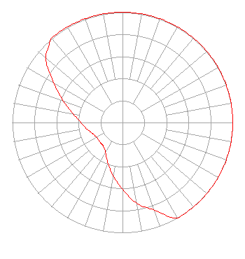 | ||||||||||||||||||||||||
| Azimuth | Ratio | Azimuth | Ratio | Azimuth | Ratio | Azimuth | Ratio | ||||||||||||||||||
| 0 | 1.000 | 10 | 1.000 | 20 | 1.000 | 30 | 1.000 | ||||||||||||||||||
| 40 | 1.000 | 45 | 1.000 | 50 | 1.000 | 60 | 1.000 | ||||||||||||||||||
| 70 | 1.000 | 80 | 1.000 | 90 | 1.000 | 100 | 1.000 | ||||||||||||||||||
| 110 | 1.000 | 120 | 1.000 | 130 | 1.000 | 135 | 1.000 | ||||||||||||||||||
| 140 | 1.000 | 150 | 1.000 | 160 | 0.845 | 170 | 0.745 | ||||||||||||||||||
| 180 | 0.605 | 190 | 0.490 | 200 | 0.390 | 210 | 0.310 | ||||||||||||||||||
| 220 | 0.275 | 225 | 0.273 | 230 | 0.270 | 240 | 0.270 | ||||||||||||||||||
| 250 | 0.290 | 260 | 0.330 | 270 | 0.380 | 280 | 0.455 | ||||||||||||||||||
| 290 | 0.572 | 300 | 0.719 | 310 | 0.905 | 315 | 0.953 | ||||||||||||||||||
| 320 | 1.000 | 330 | 1.000 | 340 | 1.000 | 350 | 1.000 | ||||||||||||||||||
Structure Registration Number 1015475 Structure Type: TOWER Registered To: VB Nimbus, LLC Structure Address: 4009 York St Oregon, OH County Name: Lucas County ASR Issued: 10/13/2020 Date Built: 01/26/1982 Site Elevation: 179.9 m (590 ft.) Structure Height: 159.8 m (524 ft.) Height Overall: 160.7 m (527 ft.) Overall Height AMSL: 340.6 m (1117 ft.) FAA Study #: N/A Paint & Light FAA Chapters: 1, 3, 4, 12, 21 41-40-05.0 N 83-27-11.0 W (NAD 83) 41-40-04.8 N 83-27-11.2 W (Converted to NAD 27) |
780 Johnson Ferry Road Suite 500 Atlanta, GA 30342 Phone: 404-949-0700 Limited Liability Company | Date: 03/01/2007 Application Certifier CUMULUS LICENSING LLC 3535 Piedmont Road Building 14, Suite 1400 Atlanta, GA 30305-4601 Applicant JEFFERSON G. BROCK Graham Brock, Inc. P. O. Box 24466 St. Simons Island, GA 31522-7466 TECHNICAL CONSULTANT MARK N. LIPP, ESQ. Wiley Rein Llp | |||||||||||||||||||||||
| |||||||||||||||||||||||||