
FCCInfo.com
A Service of Cavell, Mertz & Associates, Inc.
(855) FCC-INFO
|
|
KNRK from 05/11/1992 KNRK from 03/25/1991 KNRK from 10/30/1990 |
|  |
|
|||||||||||||||
|
|
KNRK Channel: 234C2 94.7 MHz Camas, Washington Service: FM - A full-service FM station or application. Facility ID: 51213 Fac. Service: FM Analog & Digital Status: License 73.215 Station Application Accepted: 03/26/2003 Application Granted: 10/29/2004 File Number: BLH-20030326AIC License Expires: 00/00/0000 Prefix Type: This is a license for a commercial FM station Application Type: License To Cover FCC Website Links: LMS Facility Details This Application CDBS Application Other KNRK Applications Other KNRK Applications in CDBS Including Superseded Applications Mailing Address Correspondence for KNRK Correspondence related to application BLH-20030326AIC Service Contour - Open Street Map or USGS Map (60 dBu) Service Contour - KML / Google Earth (60 dBu) Public Inspection Files Facility Type: FM STATION Class: C2, A Zone II station; with 25kW-50kW ERP and a class contour distance 39km-52km Site Location: 45-29-19.4 N 122-41-44.3 W (NAD 83) Site Location: 45-29-20.0 N 122-41-40.0 W (Converted to NAD 27) Effective Radiated Power: 6.3 kW Transmitter Output Power: 12 kW Antenna Center HAAT: 403 m (1322 ft.) Antenna Center AMSL: 497 m (1631 ft.) Antenna Center HAG: 187 m (614 ft.) Calculated Site Elevation: 310 m. (1017 ft.) Height Overall*: 189 m (620 ft.) (* As Filed In This Application, may differ from ASR Data, Below.) Directional Antenna Antenna Make/Model: Shivley 6810-1R-DA Antenna ID: 43690 Polarization: | ||||||||||||||||||
| Antenna Data for Antenna Id: 43690 KNRK FM File: BLH-20030326AIC Shivley - 6810-1R-DA Service: FM | 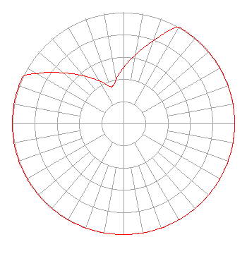 | ||||||||||||||||||
| Azimuth | Ratio | Azimuth | Ratio | Azimuth | Ratio | Azimuth | Ratio | ||||||||||||
| 0 | 0.501 | 10 | 0.631 | 20 | 0.794 | 30 | 1.000 | ||||||||||||
| 40 | 1.000 | 50 | 1.000 | 60 | 1.000 | 70 | 1.000 | ||||||||||||
| 80 | 1.000 | 90 | 1.000 | 100 | 1.000 | 110 | 1.000 | ||||||||||||
| 120 | 1.000 | 130 | 1.000 | 140 | 1.000 | 150 | 1.000 | ||||||||||||
| 160 | 1.000 | 170 | 1.000 | 180 | 1.000 | 190 | 1.000 | ||||||||||||
| 200 | 1.000 | 210 | 1.000 | 220 | 1.000 | 230 | 1.000 | ||||||||||||
| 240 | 1.000 | 250 | 1.000 | 260 | 1.000 | 270 | 1.000 | ||||||||||||
| 280 | 1.000 | 290 | 1.000 | 295 | 1.000 | 300 | 0.891 | ||||||||||||
| 310 | 0.708 | 320 | 0.562 | 330 | 0.447 | 340 | 0.355 | ||||||||||||
| 345 | 0.355 | 350 | 0.398 | ||||||||||||||||
Structure Registration Number 1033770 Structure Type: TOWER Registered To: Stonehenge Towers, LLC Structure Address: 4700 Council Crest Dr Portland, OR County Name: Multnomah County ASR Issued: 07/09/2008 Date Built: 06/05/1991 Site Elevation: 310.3 m (1018 ft.) Structure Height: 153.9 m (505 ft.) Height Overall: 189 m (620 ft.) Overall Height AMSL: 499.3 m (1638 ft.) FAA Determination: 08/13/2002 FAA Study #: 2002-ANM-1415-OE FAA Circular #: 70/7460-1K Paint & Light FAA Chapters: 3, 4, 5, 12 Removed expiration date from determination. Scenario 1./jjs/case#635066 45-29-19.4 N 122-41-44.4 W (NAD 83) 45-29-20.0 N 122-41-40.1 W (Converted to NAD 27) |
2400 Market Street 4th Floor Philadelphia, PA 19103 Phone: 610-660-5610 Limited Liability Company | Date: 03/26/2003 Application Certifier ENTERCOM PORTLAND LICENSE, LLC 401 City Avenue, Suite 409 Bala Cynwyd, PA 19004 Applicant BRIAN M. MADDEN Leventhal Senter & Lerman P.l.l.c. MARTIN D. HADFIELD 1820 Eastlake Avenue East Seattle, WA 98102 VICE PRESIDENT-ENGINEERING | |||||||||||||||||
| |||||||||||||||||||