
FCCInfo.com
A Service of Cavell, Mertz & Associates, Inc.
(855) FCC-INFO
|
|
WGJU from 11/24/2008 WGJU from 09/06/2005 WGJU from 03/20/1998 |
|  |
|
|||||||||||||||
|
|
WGJU Channel: 217C3 91.3 MHz East Tawas, Michigan Service: FM - A full-service FM station or application. Facility ID: 90268 Fac. Service: FM Status: License Application Accepted: 07/24/2008 Application Granted: 07/30/2008 File Number: BLED-20080724AAN License Expires: 00/00/0000 Prefix Type: This is a license for a noncommercial educational FM station Application Type: License To Cover FCC Website Links: LMS Facility Details This Application CDBS Application Other WGJU Applications Other WGJU Applications in CDBS Including Superseded Applications Mailing Address Correspondence for WGJU Correspondence related to application BLED-20080724AAN Service Contour - Open Street Map or USGS Map (60 dBu) Service Contour - KML / Google Earth (60 dBu) Public Inspection Files Facility Type: NON-COMMERCIAL EDUC. FM Class: C3, A Zone II station; with 6kW-25kW ERP and a class contour distance 28km-39km Site Location: 44-16-25.1 N 83-39-47.9 W (NAD 83) Site Location: 44-16-25.0 N 83-39-48.0 W (Converted to NAD 27) Effective Radiated Power: 0 kW Horiz. ; 20 kW Vert. Transmitter Output Power: 6.6 kW Antenna Center HAAT: 0 m Horiz.; 82 m Vert. Antenna Center AMSL: 0 m Horiz.; 296 m Vert. Antenna Center HAG: 0 m Horiz.; 80 m Vert. Calculated Site Elevation: m. Height Overall*: 98.5 m (323 ft.) (* As Filed In This Application, may differ from ASR Data, Below.) Directional Antenna Antenna Make/Model: Systems With Reliability Inc. FM10VR/2 DA Antenna ID: 84650 Polarization:
| ||||||||||||||||||
| Antenna Data for Antenna Id: 84650 WGJU FM File: BLED-20080724AAN Systems With Reliability Inc. - FM10VR/2 DA Service: FM | 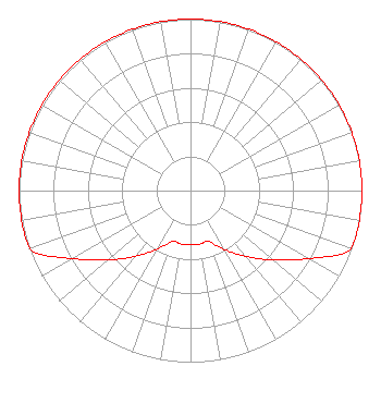 | ||||||||||||||||||
| Azimuth | Ratio | Azimuth | Ratio | Azimuth | Ratio | Azimuth | Ratio | ||||||||||||
| 0 | 1.000 | 10 | 1.000 | 20 | 1.000 | 30 | 1.000 | ||||||||||||
| 40 | 1.000 | 50 | 1.000 | 60 | 1.000 | 70 | 1.000 | ||||||||||||
| 80 | 1.000 | 90 | 1.000 | 100 | 1.000 | 110 | 0.999 | ||||||||||||
| 120 | 0.793 | 130 | 0.630 | 140 | 0.501 | 150 | 0.398 | ||||||||||||
| 160 | 0.316 | 170 | 0.316 | 180 | 0.316 | 190 | 0.316 | ||||||||||||
| 200 | 0.316 | 210 | 0.398 | 220 | 0.501 | 230 | 0.630 | ||||||||||||
| 240 | 0.793 | 250 | 0.999 | 260 | 1.000 | 270 | 1.000 | ||||||||||||
| 280 | 1.000 | 290 | 1.000 | 300 | 1.000 | 310 | 1.000 | ||||||||||||
| 320 | 1.000 | 330 | 1.000 | 340 | 1.000 | 350 | 1.000 | ||||||||||||
Structure Registration Number 1007360 [ASR Heights Differ from WGJU Application] Structure Type: TOWER Registered To: Carroll Enterprises, Inc. Structure Address: 125 S Binder Rd Tawas City, MI County Name: Iosco County ASR Issued: 03/20/2019 Date Built: 10/01/1994 Site Elevation: 216.4 m (710 ft.) Structure Height: 97.6 m (320 ft.) Height Overall: 98.5 m (323 ft.) Overall Height AMSL: 314.9 m (1033 ft.) Paint & Light FAA Chapters: 1, 3, 12, 21 44-16-25.0 N 83-39-48.0 W (NAD 83) 44-16-24.9 N 83-39-48.1 W (Converted to NAD 27) |
680 Barclay Boulevard Lincolnshire, IL 60069 Phone: 877-291-0123 Not-for-Profit | Date: 07/24/2008 Application Certifier NORTHERN CHRISTIAN RADIO, INC. Po Box 695 Gaylord, MI 49734-0695 Applicant DEL REYNOLDS 4225 East Burt Lake Rd. Cheboygan, MI 49721 CONSULTING ENGINEER MATTHEW H. MCCORMICK Fletcher, Heald & Hildreth, P.l.c. | |||||||||||||||||