
FCCInfo.com
A Service of Cavell, Mertz & Associates, Inc.
(855) FCC-INFO
|
|
|
|  |
|
|||||||||||||||
|
|
WOES Channel: 217A 91.3 MHz Ovid-elsie, Michigan Service: FM - A full-service FM station or application. Facility ID: 50794 Fac. Service: FM Status: License Application Accepted: 07/26/2016 Application Granted: 08/01/2016 File Number: BMLED-20160726ABJ License Expires: 00/00/0000 Prefix Type: This is a modification of license for a noncommercial educational FM station Application Type: Minor Modification FCC Website Links: LMS Facility Details This Application CDBS Application Other WOES Applications Other WOES Applications in CDBS Including Superseded Applications Mailing Address Correspondence for WOES Correspondence related to application BMLED-20160726ABJ Service Contour - Open Street Map or USGS Map (60 dBu) Service Contour - KML / Google Earth (60 dBu) Public Inspection Files History Cards for WOES Facility Type: NON-COMMERCIAL EDUC. FM Class: A, A Zone I; I-A; or II station; with 0.1kW-6kW ERP and a class contour distance <=28km Site Location: 43-02-46.1 N 84-23-16.9 W (NAD 83) Site Location: 43-02-46.0 N 84-23-17.0 W (Converted to NAD 27) Effective Radiated Power: 0.55 kW Transmitter Output Power: 0.3 kW Antenna Center HAAT: 51 m (167 ft.) Antenna Center AMSL: 274 m (899 ft.) Antenna Center HAG: 41 m (135 ft.) Calculated Site Elevation: 233 m. (764 ft.) Height Overall*: 44.2 m (145 ft.) (* As Filed In This Application, may differ from ASR Data, Below.) Directional Antenna Antenna Make/Model: Jampro JLLP-2D, two sections Antenna ID: 13486 Polarization: | ||||||||||||||||||
| Antenna Data for Antenna Id: 13486 WOES FM File: BMLED-20160726ABJ Jampro - JLLP-2D, two sections Service: FM | 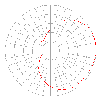 | ||||||||||||||||||
| Azimuth | Ratio | Azimuth | Ratio | Azimuth | Ratio | Azimuth | Ratio | ||||||||||||
| 0 | 0.470 | 10 | 0.570 | 20 | 0.680 | 30 | 0.780 | ||||||||||||
| 40 | 0.860 | 50 | 0.930 | 60 | 0.980 | 70 | 1.000 | ||||||||||||
| 80 | 1.000 | 90 | 1.000 | 100 | 0.990 | 110 | 0.980 | ||||||||||||
| 120 | 0.960 | 130 | 0.950 | 140 | 0.950 | 150 | 0.940 | ||||||||||||
| 160 | 0.910 | 170 | 0.860 | 180 | 0.790 | 190 | 0.700 | ||||||||||||
| 200 | 0.610 | 210 | 0.510 | 220 | 0.400 | 230 | 0.310 | ||||||||||||
| 240 | 0.240 | 250 | 0.200 | 260 | 0.190 | 270 | 0.220 | ||||||||||||
| 280 | 0.280 | 290 | 0.300 | 300 | 0.300 | 310 | 0.290 | ||||||||||||
| 320 | 0.270 | 330 | 0.280 | 340 | 0.330 | 350 | 0.390 | ||||||||||||
Structure Registration Number 1062503 Structure Type: LTOWER Registered To: OVID ELSIE SCHOOLS Structure Address: 8989 Colony Rd Elsie, MI County Name: Clinton County ASR Issued: 07/14/2016 Date Built: 06/01/1979 Site Elevation: 232.6 m (763 ft.) Structure Height: 44.2 m (145 ft.) Height Overall: 44.2 m (145 ft.) Overall Height AMSL: 276.8 m (908 ft.) FAA Determination: 05/17/2016 FAA Study #: 2016-AGL-6590-OE Paint & Light FAA Chapters: NONE 43-02-45.7 N 84-23-17.0 W (NAD 83) 43-02-45.6 N 84-23-17.1 W (Converted to NAD 27) |
8989 Colony Road 989) 834- 2271 Elsie, MI 48831 Phone: 989-834-2271 Not-for-Profit | Date: 07/26/2016 Application Certifier OVID-ELSIE AREA SCHOOLS 8989 Colony Road Elsie, MI 48831 Applicant JUSTIN W. ASHER Munn-reese, Inc. Po Box 220 - 385 Airport Drive Coldwater, MI 49036-0220 CONSULTING ENGINEER MATTHEW MCCORMICK, ESQ. Fletcher, Heald & Hildreth, P.l.c. | |||||||||||||||||