
FCCInfo.com
A Service of Cavell, Mertz & Associates, Inc.
(855) FCC-INFO
|
|
W246DV from 01/25/2018 W246DV from 07/08/2016 W246DV from 11/16/2009 W246DV from 10/27/2009 W246DV from 04/29/1998 |
|
|
||||||||||||||||
|
|
W246DV Channel: 246D 97.1 MHz South Bend, Indiana Service: FX - A translator or application for a translator. Facility ID: 89020 Fac. Service: FX Programming Delivery Method: Unspecified Status: License Application Accepted: 03/28/2019 Application Granted: 04/02/2019 File Number: BLFT-20190328AAU License Expires: 00/00/0000 Prefix Type: This is a license for a translator Application Type: License To Cover FCC Website Links: LMS Facility Details This Application CDBS Application Other W246DV Applications Other W246DV Applications in CDBS Including Superseded Applications Mailing Address Correspondence for W246DV Correspondence related to application BLFT-20190328AAU Service Contour - Open Street Map or USGS Map (60 dBu) Service Contour - KML / Google Earth (60 dBu) Class: D, A Noncommercial educational operating with no more than 10W Site Location: 41-44-16.2 N 86-15-10.0 W (NAD 83) Site Location: 41-44-16.0 N 86-15-10.0 W (Converted to NAD 27) Effective Radiated Power: 0.25 kW Transmitter Output Power: 0.484 kW Antenna Center HAAT: 0 m Antenna Center AMSL: 305 m (1001 ft.) Antenna Center HAG: 86 m (282 ft.) Site Elevation: 219 m. (719 ft.) Height Overall*: 98 m (322 ft.) (* As Filed In This Application, may differ from ASR Data, Below.) Directional Antenna Antenna Make/Model: None Antenna ID: 133669 Polarization:
| ||||||||||||||||||
| Antenna Data for Antenna Id: 133669 W246DV FX File: BLFT-20190328AAU None - Service: FX Pattern and Field Values Include a 38° Clockwise Rotation | 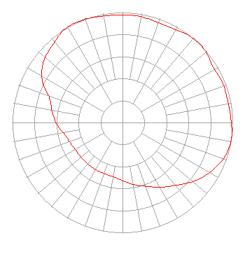 | ||||||||||||||||||
| Azimuth | Ratio | Azimuth | Ratio | Azimuth | Ratio | Azimuth | Ratio | ||||||||||||
| 8 | 0.975 | 18 | 0.965 | 28 | 0.965 | 38 | 0.995 | ||||||||||||
| 48 | 0.995 | 58 | 0.965 | 68 | 0.975 | 78 | 0.975 | ||||||||||||
| 88 | 0.983 | 98 | 0.999 | 108 | 0.981 | 118 | 0.926 | ||||||||||||
| 128 | 0.851 | 138 | 0.761 | 148 | 0.691 | 158 | 0.626 | ||||||||||||
| 168 | 0.580 | 178 | 0.535 | 188 | 0.503 | 198 | 0.492 | ||||||||||||
| 208 | 0.492 | 218 | 0.492 | 228 | 0.492 | 238 | 0.492 | ||||||||||||
| 248 | 0.506 | 258 | 0.535 | 268 | 0.595 | 278 | 0.642 | ||||||||||||
| 288 | 0.695 | 298 | 0.825 | 308 | 0.907 | 318 | 0.946 | ||||||||||||
| 328 | 0.995 | 338 | 0.999 | 348 | 0.983 | 358 | 0.975 | ||||||||||||
Structure Registration Number 1234297 Structure Type: TOWER Registered To: Pathfinder Communications Corporation Structure Address: 30m North Of Brick Road, 150m West Of Us 33 South Bend, IN County Name: St. Joseph County ASR Issued: 01/15/2008 Date Built: 01/13/2003 Site Elevation: 218.9 m (718 ft.) Structure Height: 96.9 m (318 ft.) Height Overall: 97.8 m (321 ft.) Overall Height AMSL: 316.7 m (1039 ft.) FAA Determination: 05/17/2002 FAA Study #: 02-AGL-1391-OE FAA Circular #: 70/7460-1K Paint & Light FAA Chapters: 3, 4, 5, 12 Removed expiration date from determination. Scenario 1./jjs/case#635066 41-44-16.2 N 86-15-10.0 W (NAD 83) 41-44-16.0 N 86-15-10.0 W (Converted to NAD 27) |
6040 South Bishop Street Chicago, IL 60636-2306 Phone: 312-848-0361 | Date: 03/28/2019 Application Certifier LARRY LANGFORD, JR. 6040 South Bishop Street Chicago, IL 60636-2306 Applicant LARRY LANGFORD 6040 Bishop Street Chicago, IL 60636 OWNER LAWRENCE W. LANGFORD Langford 6040 Bishop Street Chicago, IL 60636-2306 | |||||||||||||||||