
FCCInfo.com
A Service of Cavell, Mertz & Associates, Inc.
(855) FCC-INFO
|
|
W244CF from 11/09/2004 |
|
|
||||||||||||||||
|
|
W244CF Channel: 244D 96.7 MHz Plymouth, Massachusetts Service: FX - A translator or application for a translator. Facility ID: 138875 Fac. Service: FX Programming Delivery Method: Unspecified Status: License Application Accepted: 05/04/2010 Application Granted: 05/13/2010 File Number: BLFT-20100504ABL License Expires: 00/00/0000 Prefix Type: This is a license for a translator Application Type: License To Cover FCC Website Links: LMS Facility Details This Application CDBS Application Other W244CF Applications Other W244CF Applications in CDBS Including Superseded Applications Mailing Address Correspondence for W244CF Correspondence related to application BLFT-20100504ABL Service Contour - Open Street Map or USGS Map (60 dBu) Service Contour - KML / Google Earth (60 dBu) Class: D, A Noncommercial educational operating with no more than 10W Site Location: 41-47-58.4 N 70-32-38.1 W (NAD 83) Site Location: 41-47-58.0 N 70-32-40.0 W (Converted to NAD 27) Effective Radiated Power: 0 kW Horiz. ; 0.01 kW Vert. Transmitter Output Power: 0.003 kW Antenna Center HAAT: 0 m Horiz.; 76.9 m Vert. Antenna Center AMSL: 0 m Horiz.; 92 m Vert. Antenna Center HAG: 0 m Horiz.; 58 m Vert. Site Elevation: 34 m. (112 ft.) Height Overall*: 61 m (200 ft.) (* As Filed In This Application, may differ from ASR Data, Below.) Directional Antenna Antenna Make/Model: None Antenna ID: 87986 Polarization:
| ||||||||||||||||||
| Antenna Data for Antenna Id: 87986 W244CF FX File: BLFT-20100504ABL None - Service: FX Pattern and Field Values Include a 160° Clockwise Rotation | 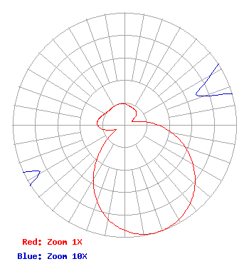 | ||||||||||||||||||
| Azimuth | Ratio | Azimuth | Ratio | Azimuth | Ratio | Azimuth | Ratio | ||||||||||||
| 0 | 0.187 | 10 | 0.178 | 20 | 0.169 | 30 | 0.165 | ||||||||||||
| 40 | 0.160 | 50 | 0.138 | 60 | 0.089 | 70 | 0.075 | ||||||||||||
| 80 | 0.170 | 90 | 0.299 | 100 | 0.438 | 110 | 0.576 | ||||||||||||
| 120 | 0.705 | 130 | 0.821 | 140 | 0.911 | 150 | 0.972 | ||||||||||||
| 160 | 1.000 | 170 | 0.989 | 180 | 0.939 | 190 | 0.851 | ||||||||||||
| 200 | 0.719 | 210 | 0.557 | 220 | 0.371 | 230 | 0.197 | ||||||||||||
| 240 | 0.088 | 250 | 0.139 | 260 | 0.207 | 270 | 0.241 | ||||||||||||
| 280 | 0.240 | 290 | 0.220 | 300 | 0.200 | 310 | 0.189 | ||||||||||||
| 320 | 0.186 | 330 | 0.188 | 340 | 0.192 | 350 | 0.189 | ||||||||||||
Structure Registration Number 1204108 Structure Type: GTOWER Registered To: Industrial Tower and Wireless, LLC Structure Address: 391 Old Plymouth Road Bourne, MA County Name: Barnstable County ASR Issued: 03/06/2023 Date Built: 05/24/2000 Site Elevation: 34.4 m (113 ft.) Structure Height: 57.9 m (190 ft.) Height Overall: 60.9 m (200 ft.) Overall Height AMSL: 95.3 m (313 ft.) FAA Determination: 03/02/2023 FAA Study #: 2022-ANE-2189-OE Paint & Light FAA Chapters: NONE PRIOR STUDY 2001-ANE-669-OE 41-47-58.4 N 70-32-37.7 W (NAD 83) 41-47-58.0 N 70-32-39.6 W (Converted to NAD 27) |
356 Broad Street Fitchburg, MA 01420 Phone: 978-655-9111 Private Not-for-Profit Educational Institution | Date: 05/04/2010 Application Certifier HORIZON CHRISTIAN FELLOWSHIP 356 Broad Street Fitchburg, MA 01420 Applicant ROBERT MOORE 1908 Sweetbriar Dr Goshen, IN 46528 CONSULTING ENGINEER SHOBA S. SPENCER The Law Office Of Shoba S. Spencer 816 Main Street Medford, MA 02155 | |||||||||||||||||