
FCCInfo.com
A Service of Cavell, Mertz & Associates, Inc.
(855) FCC-INFO
|
|
K227BW from 08/11/1982 |
|
|
||||||||||||||||
|
|
K227BW Channel: 227D 93.3 MHz Pullman, Washington Service: FX - A translator or application for a translator. Facility ID: 71040 Fac. Service: FX Programming Delivery Method: Unspecified Status: License Application Accepted: 06/17/2013 Application Granted: 07/16/2013 File Number: BLFT-20130617ABX License Expires: 00/00/0000 Prefix Type: This is a license for a translator Application Type: License To Cover FCC Website Links: LMS Facility Details This Application CDBS Application Other K227BW Applications Other K227BW Applications in CDBS Including Superseded Applications Mailing Address Correspondence for K227BW Correspondence related to application BLFT-20130617ABX Service Contour - Open Street Map or USGS Map (60 dBu) Service Contour - KML / Google Earth (60 dBu) Class: D, A Noncommercial educational operating with no more than 10W Site Location: 46-40-53.6 N 116-58-16.6 W (NAD 83) Site Location: 46-40-54.0 N 116-58-13.0 W (Converted to NAD 27) Effective Radiated Power: 0.5 kW Transmitter Output Power: 0.155 kW Antenna Center HAAT: 273.9 m Horiz.; 0 m Vert. Antenna Center AMSL: 1117 m (3665 ft.) Antenna Center HAG: 20 m (66 ft.) Site Elevation: 1097 m. (3599 ft.) Height Overall*: 101 m (331 ft.) (* As Filed In This Application, may differ from ASR Data, Below.) Directional Antenna Antenna Make/Model: None Antenna ID: 16149 Polarization:
| ||||||||||||||||||
| Antenna Data for Antenna Id: 16149 K227BW FX File: BLFT-20130617ABX None - Service: FX Pattern and Field Values Include a 310° Clockwise Rotation | 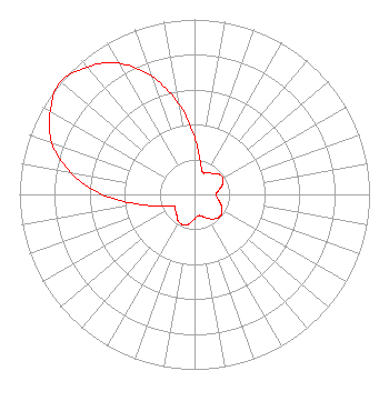 | ||||||||||||||||||
| Azimuth | Ratio | Azimuth | Ratio | Azimuth | Ratio | Azimuth | Ratio | ||||||||||||
| 0 | 0.329 | 10 | 0.190 | 20 | 0.134 | 30 | 0.142 | ||||||||||||
| 40 | 0.157 | 50 | 0.181 | 60 | 0.187 | 70 | 0.171 | ||||||||||||
| 80 | 0.140 | 90 | 0.123 | 100 | 0.135 | 110 | 0.160 | ||||||||||||
| 120 | 0.182 | 130 | 0.193 | 140 | 0.182 | 150 | 0.160 | ||||||||||||
| 160 | 0.135 | 170 | 0.123 | 180 | 0.140 | 190 | 0.171 | ||||||||||||
| 200 | 0.187 | 210 | 0.181 | 220 | 0.157 | 230 | 0.142 | ||||||||||||
| 240 | 0.134 | 250 | 0.190 | 260 | 0.329 | 270 | 0.528 | ||||||||||||
| 280 | 0.718 | 290 | 0.866 | 300 | 0.952 | 310 | 1.000 | ||||||||||||
| 320 | 0.952 | 330 | 0.866 | 340 | 0.718 | 350 | 0.528 | ||||||||||||
Structure Registration Number 1041926 Structure Type: TOWER Registered To: STATE BOARD OF EDUCATION IDAHO IEPBS Structure Address: Paradise Ridge Nr Moscow, ID County Name: Latah County ASR Issued: 03/27/1998 Date Built: 01/01/1991 Site Elevation: 1097 m (3599 ft.) Structure Height: 76.2 m (250 ft.) Height Overall: 101.5 m (333 ft.) Overall Height AMSL: 1198.5 m (3932 ft.) FAA Determination: 08/07/1980 FAA Study #: 90-ANM-0176-OE FAA Circular #: 70/7460-1G Paint & Light FAA Chapters: 3, 4, 5, 9 46-40-54.0 N 116-58-17.0 W (NAD 83) 46-40-54.4 N 116-58-13.4 W (Converted to NAD 27) |
Educational Telecommunications And Tech. Murrow Comm Center, P.o. Box 642530 Pullman, WA 99164-2530 Phone: 509-335-6511 | Date: 06/17/2013 Application Certifier WASHINGTON STATE UNIVERSITY Edward R Murrow College Of Communication Po Box 642530 Pullman, WA 99164-2530 Applicant MARTIN L GIBBS Washington State University 2710 Crimson Way Richland, WA 99354 EMPLOYEE PROFESSIONAL WORKER BARRY S. PERSH Dow Lohnes Pllc 1200 New Hampshire Ave., N.w. Suite 800 Washington, DC 20036-6802 | |||||||||||||||||