
FCCInfo.com
A Service of Cavell, Mertz & Associates, Inc.
(855) FCC-INFO
|
|
|
|  |
|
|||||||||||||||
|
|
WVPE Channel: 201B 88.1 MHz Elkhart, Indiana Service: FM - A full-service FM station or application. Facility ID: 19365 Fac. Service: FM Analog & Digital Status: License Application Accepted: 12/22/2008 Application Granted: 12/24/2008 File Number: BLED-20081222ABZ License Expires: 00/00/0000 Prefix Type: This is a license for a noncommercial educational FM station Application Type: License To Cover FCC Website Links: LMS Facility Details This Application CDBS Application Other WVPE Applications Other WVPE Applications in CDBS Including Superseded Applications Mailing Address Correspondence for WVPE Correspondence related to application BLED-20081222ABZ Service Contour - Open Street Map or USGS Map (60 dBu) Service Contour - KML / Google Earth (60 dBu) Public Inspection Files History Cards for WVPE Facility Type: NON-COMMERCIAL EDUC. FM Class: B, A Zone I or I-A station; with 25kW-50kW ERP and a class contour distance 39km-52km Site Location: 41-36-49.2 N 86-11-20.0 W (NAD 83) Site Location: 41-36-49.0 N 86-11-20.0 W (Converted to NAD 27) Effective Radiated Power: 11.5 kW Transmitter Output Power: 4.3 kW Antenna Center HAAT: 304 m (997 ft.) Antenna Center AMSL: 547 m (1795 ft.) Antenna Center HAG: 280 m (919 ft.) Calculated Site Elevation: 267 m. (876 ft.) Height Overall*: 317.6 m (1042 ft.) (* As Filed In This Application, may differ from ASR Data, Below.) Directional Antenna Antenna Make/Model: Electronics Research Inc. LP-6E-DA-HW Antenna ID: 90689 Polarization: | ||||||||||||||||||
| Antenna Data for Antenna Id: 90689 WVPE FM File: BLED-20081222ABZ Electronics Research Inc. - LP-6E-DA-HW Service: FM | 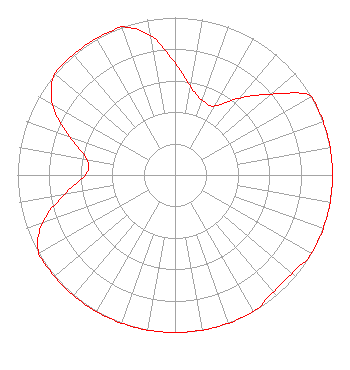 | ||||||||||||||||||
| Azimuth | Ratio | Azimuth | Ratio | Azimuth | Ratio | Azimuth | Ratio | ||||||||||||
| 0 | 0.714 | 10 | 0.568 | 20 | 0.506 | 30 | 0.506 | ||||||||||||
| 40 | 0.637 | 50 | 0.800 | 60 | 1.000 | 70 | 1.000 | ||||||||||||
| 80 | 1.000 | 90 | 1.000 | 100 | 1.000 | 110 | 1.000 | ||||||||||||
| 120 | 1.000 | 130 | 0.970 | 140 | 0.970 | 150 | 1.000 | ||||||||||||
| 160 | 1.000 | 170 | 1.000 | 180 | 1.000 | 190 | 1.000 | ||||||||||||
| 200 | 1.000 | 210 | 1.000 | 220 | 1.000 | 230 | 1.000 | ||||||||||||
| 240 | 1.000 | 250 | 0.898 | 260 | 0.714 | 270 | 0.568 | ||||||||||||
| 280 | 0.568 | 290 | 0.714 | 300 | 0.898 | 310 | 1.000 | ||||||||||||
| 320 | 1.000 | 330 | 1.000 | 340 | 1.000 | 350 | 0.898 | ||||||||||||
Structure Registration Number 1237678 Structure Type: GTOWER Registered To: Charles S. Hayes Inc Structure Address: 0.9 Kilometers Northeast Of Intersection Of Hickory & Kern Roads South Bend, IN County Name: St. Joseph County ASR Issued: 02/16/2016 Date Built: 04/12/2003 Site Elevation: 266.7 m (875 ft.) Structure Height: 316.7 m (1039 ft.) Height Overall: 317.6 m (1042 ft.) Overall Height AMSL: 584.3 m (1917 ft.) FAA Determination: 11/08/2013 FAA Study #: 2013-AGL-10291-OE FAA Circular #: 70/7460-1K Paint & Light FAA Chapters: 3, 4, 5, 12 PRIOR STUDY 2003-AGL-2368-OE 41-36-49.2 N 86-11-20.0 W (NAD 83) 41-36-49.0 N 86-11-20.0 W (Converted to NAD 27) |
2424 California Road Elkhart, IN 46514 Phone: 574-262-5520 Government Entity | Date: 12/22/2008 Application Certifier ELKHART COMMUNITY SCHOOLS Station Wvpe 2424 California Road Elkhart, IN 46514 Applicant JUSTIN W. ASHER Munn-reese, Inc. Po Box 220, 385 Airport Dr. Coldwater, MI 49036-0220 CONSULTING ENGINEER ANTHONY HUNT Station Wvpe | |||||||||||||||||
|
| ||||||||||||||||||