
FCCInfo.com
A Service of Cavell, Mertz & Associates, Inc.
(855) FCC-INFO
|
|
|
|
|
||||||||||||||||
|
|
W292EO Channel: 292D 106.3 MHz Decatur, Illinois Service: FX - A translator or application for a translator. Facility ID: 138454 Fac. Service: FX Programming Delivery Method: Unspecified Status: License Application Accepted: 08/31/2015 Application Granted: 09/18/2015 File Number: BLFT-20150831ADF License Expires: 00/00/0000 Prefix Type: This is a license for a translator Application Type: License To Cover FCC Website Links: LMS Facility Details This Application CDBS Application Other W292EO Applications Other W292EO Applications in CDBS Including Superseded Applications Mailing Address Correspondence for W292EO Correspondence related to application BLFT-20150831ADF Service Contour - Open Street Map or USGS Map (60 dBu) Service Contour - KML / Google Earth (60 dBu) Class: D, A Noncommercial educational operating with no more than 10W Site Location: 39-49-28.1 N 88-58-03.3 W (NAD 83) Site Location: 39-49-28.0 N 88-58-03.0 W (Converted to NAD 27) Effective Radiated Power: 0.045 kW Transmitter Output Power: 0.166 kW Antenna Center HAAT: 0 m Antenna Center AMSL: 365 m (1198 ft.) Antenna Center HAG: 168 m (551 ft.) Site Elevation: 197 m. (646 ft.) Height Overall*: 184 m (604 ft.) (* As Filed In This Application, may differ from ASR Data, Below.) Directional Antenna Antenna Make/Model: None Antenna ID: 121522 Polarization:
| ||||||||||||||||||
| Antenna Data for Antenna Id: 121522 W292EO FX File: BLFT-20150831ADF None - Service: FX | 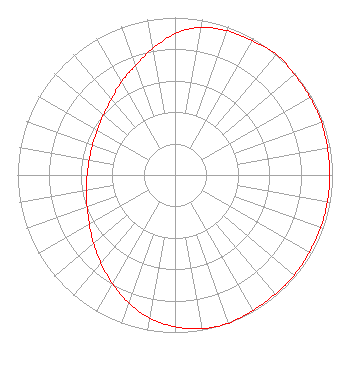 | ||||||||||||||||||
| Azimuth | Ratio | Azimuth | Ratio | Azimuth | Ratio | Azimuth | Ratio | ||||||||||||
| 0 | 0.897 | 10 | 0.953 | 20 | 0.973 | 30 | 0.983 | ||||||||||||
| 40 | 1.000 | 50 | 0.992 | 60 | 0.988 | 70 | 0.988 | ||||||||||||
| 80 | 0.983 | 90 | 0.983 | 100 | 0.983 | 110 | 0.983 | ||||||||||||
| 120 | 0.983 | 130 | 0.988 | 140 | 0.988 | 150 | 0.992 | ||||||||||||
| 160 | 1.000 | 170 | 0.991 | 180 | 0.963 | 190 | 0.923 | ||||||||||||
| 200 | 0.862 | 210 | 0.797 | 220 | 0.731 | 230 | 0.676 | ||||||||||||
| 240 | 0.628 | 250 | 0.594 | 260 | 0.571 | 270 | 0.558 | ||||||||||||
| 280 | 0.553 | 290 | 0.558 | 300 | 0.571 | 310 | 0.594 | ||||||||||||
| 320 | 0.628 | 330 | 0.682 | 340 | 0.738 | 350 | 0.815 | ||||||||||||
Structure Registration Number 1009650 [ASR Heights Differ from W292EO Application] Structure Type: Registered To: WAND(TV) Partnership Structure Address: 904 South Side Drive Decatur, IL County Name: Macon County ASR Issued: 07/10/2017 Date Built: 06/01/1953 Site Elevation: 196.3 m (644 ft.) Structure Height: 167.6 m (550 ft.) Height Overall: 183.5 m (602 ft.) Overall Height AMSL: 379.8 m (1246 ft.) FAA Determination: 05/04/2012 FAA Study #: 2012-AGL-2897-OE Paint & Light FAA Chapters: 1, 3, 5, 14, 21 Continue As Is OM&L = PAINT/RED LIGHTS 39-49-28.6 N 88-58-03.6 W (NAD 83) 39-49-28.5 N 88-58-03.3 W (Converted to NAD 27) |
P.o. Box 150846 Nashville, TN 38215 Phone: 615-361-7560 | Date: 08/31/2015 Application Certifier THE CROMWELL GROUP, INC. OF ILLINOIS P.o. Box 150846 Nashville, TN 37215-0846 Applicant JERALD L. SCOTT 112 Country Club Drive Pekin, IL 61554 ENGINEER JOHN F. GARZIGLIA, ESQ. Womble Carlyle Sandridge & Rice, Llp 1200 19th Street, N.w., Suite 500 Washington, DC 20036 | |||||||||||||||||