
FCCInfo.com
A Service of Cavell, Mertz & Associates, Inc.
(855) FCC-INFO
|
|
|
|
|
||||||||||||||||
|
|
WDTE Channel: 202A 88.3 MHz Grosse Point Shores, Michigan Service: FM - A full-service FM station or application. Facility ID: 175093 Fac. Service: FM Status: License Application Accepted: 06/05/2012 Application Granted: 10/16/2012 File Number: BLED-20120605ABF License Expires: 00/00/0000 Prefix Type: This is a license for a noncommercial educational FM station Application Type: License To Cover FCC Website Links: LMS Facility Details This Application CDBS Application Other WDTE Applications Other WDTE Applications in CDBS Including Superseded Applications Mailing Address Correspondence for WDTE Correspondence related to application BLED-20120605ABF Service Contour - Open Street Map or USGS Map (60 dBu) Service Contour - KML / Google Earth (60 dBu) Public Inspection Files Facility Type: NON-COMMERCIAL EDUC. FM Class: A, A Zone I; I-A; or II station; with 0.1kW-6kW ERP and a class contour distance <=28km Site Location: 42-28-26.7 N 82-53-08.3 W (NAD 83) Site Location: 42-28-26.6 N 82-53-08.6 W (Converted to NAD 27) Effective Radiated Power: 0.16 kW Horiz. ; 5.5 kW Vert. Transmitter Output Power: 1.95 kW Antenna Center HAAT: 50 m (164 ft.) Antenna Center AMSL: 225 m (738 ft.) Antenna Center HAG: 48.8 m (160 ft.) Calculated Site Elevation: 176.2 m. (578 ft.) Height Overall*: 53 m (174 ft.) (* As Filed In This Application, may differ from ASR Data, Below.) Directional Antenna Antenna Make/Model: ETC FM-1V-DA PLUS FM-1H-ND Antenna ID: 88071 Polarization:
| ||||||||||||||||||
| Antenna Data for Antenna Id: 88071 WDTE FM File: BLED-20120605ABF ETC - FM-1V-DA PLUS FM-1H-ND Service: FM | 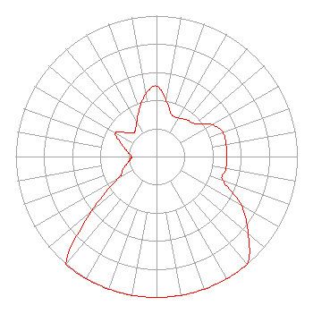 | ||||||||||||||||||
| Azimuth | Ratio | Azimuth | Ratio | Azimuth | Ratio | Azimuth | Ratio | ||||||||||||
| 0 | 0.501 | 10 | 0.398 | 20 | 0.316 | 30 | 0.316 | ||||||||||||
| 40 | 0.338 | 50 | 0.361 | 60 | 0.454 | 70 | 0.501 | ||||||||||||
| 80 | 0.501 | 90 | 0.501 | 100 | 0.501 | 110 | 0.501 | ||||||||||||
| 120 | 0.698 | 130 | 0.849 | 140 | 1.000 | 150 | 1.000 | ||||||||||||
| 160 | 1.000 | 170 | 1.000 | 180 | 1.000 | 190 | 1.000 | ||||||||||||
| 200 | 1.000 | 210 | 1.000 | 220 | 1.000 | 230 | 0.600 | ||||||||||||
| 240 | 0.316 | 250 | 0.251 | 260 | 0.200 | 265 | 0.184 | ||||||||||||
| 270 | 0.178 | 280 | 0.211 | 290 | 0.266 | 300 | 0.335 | ||||||||||||
| 310 | 0.266 | 315 | 0.237 | 320 | 0.237 | 330 | 0.282 | ||||||||||||
| 340 | 0.355 | 350 | 0.447 | ||||||||||||||||
Structure Registration Number 1234026 Structure Type: MTOWER Registered To: SpectraSite Communications, LLC. through American Towers, LLC. Structure Address: 24800 Jefferson Blvd. (st. Clair Shores #305635) St. Claire Shores, MI County Name: Macomb County ASR Issued: 07/29/2013 Date Built: 04/01/1999 Site Elevation: 176.2 m (578 ft.) Structure Height: 50.9 m (167 ft.) Height Overall: 53 m (174 ft.) Overall Height AMSL: 229.2 m (752 ft.) FAA Determination: 11/30/2006 FAA Study #: 2006-AGL-9343-OE Paint & Light FAA Chapters: NONE PRIOR STUDY 2004-AGL-4030-OE 42-28-26.7 N 82-53-08.3 W (NAD 83) 42-28-26.6 N 82-53-08.6 W (Converted to NAD 27) |
3302 N. Van Dyke Imlay City, MI 48444 Phone: 810-724-2638 | Date: 06/05/2012 Application Certifier SMILE FM 3302 N. Van Dyke Imlay City, MI 48444 Applicant EDWARD CZELADA 3302 N. Van Dyke Rd. Imlay City, MI 48444 PRESIDENT EDWARD CZELADA Smile Fm | |||||||||||||||||