
FCCInfo.com
A Service of Cavell, Mertz & Associates, Inc.
(855) FCC-INFO
|
|
|
|  |
|
|||||||||||||||
|
|
WJWT Channel: 219A 91.7 MHz Gardner, Massachusetts Service: FM - A full-service FM station or application. Facility ID: 122204 Fac. Service: FM Status: License Application Accepted: 06/23/2006 Application Granted: 11/07/2006 File Number: BLED-20060623ABM License Expires: 00/00/0000 Prefix Type: This is a license for a noncommercial educational FM station Application Type: License To Cover FCC Website Links: LMS Facility Details This Application CDBS Application Other WJWT Applications Other WJWT Applications in CDBS Including Superseded Applications Mailing Address Correspondence for WJWT Correspondence related to application BLED-20060623ABM Service Contour - Open Street Map or USGS Map (60 dBu) Service Contour - KML / Google Earth (60 dBu) Public Inspection Files Facility Type: NON-COMMERCIAL EDUC. FM Class: A, A Zone I; I-A; or II station; with 0.1kW-6kW ERP and a class contour distance <=28km Site Location: 42-33-29.3 N 72-03-04.3 W (NAD 83) Site Location: 42-33-29.0 N 72-03-06.0 W (Converted to NAD 27) Effective Radiated Power: 0.85 kW Transmitter Output Power: 0.205 kW Antenna Center HAAT: 84 m (276 ft.) Antenna Center AMSL: 391 m (1283 ft.) Antenna Center HAG: 24 m (79 ft.) Site Elevation: 367 m. (1204 ft.) Height Overall*: 45 m (148 ft.) (* As Filed In This Application, may differ from ASR Data, Below.) Directional Antenna Antenna Make/Model: Shivley CUSTOM, one section Antenna ID: 44175 Polarization:
| ||||||||||||||||||
| Antenna Data for Antenna Id: 44175 WJWT FM File: BLED-20060623ABM Shivley - CUSTOM, one section Service: FM | 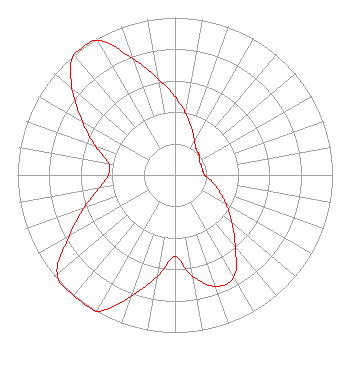 | ||||||||||||||||||
| Azimuth | Ratio | Azimuth | Ratio | Azimuth | Ratio | Azimuth | Ratio | ||||||||||||
| 0 | 0.496 | 10 | 0.394 | 20 | 0.313 | 30 | 0.248 | ||||||||||||
| 40 | 0.210 | 50 | 0.200 | 60 | 0.178 | 70 | 0.178 | ||||||||||||
| 80 | 0.178 | 90 | 0.188 | 100 | 0.237 | 110 | 0.298 | ||||||||||||
| 120 | 0.375 | 130 | 0.472 | 140 | 0.595 | 150 | 0.748 | ||||||||||||
| 160 | 0.753 | 170 | 0.652 | 180 | 0.518 | 190 | 0.652 | ||||||||||||
| 200 | 0.820 | 210 | 1.000 | 220 | 1.000 | 230 | 0.978 | ||||||||||||
| 240 | 0.777 | 250 | 0.617 | 260 | 0.490 | 270 | 0.424 | ||||||||||||
| 280 | 0.428 | 290 | 0.539 | 300 | 0.678 | 310 | 0.854 | ||||||||||||
| 320 | 1.000 | 330 | 0.989 | 340 | 0.786 | 350 | 0.624 | ||||||||||||
Structure Registration Number 1009580 [ASR Heights Differ from WJWT Application] Structure Type: TOWER Registered To: Crown Atlantic Company LLC Structure Address: Off Of Johnson Avenue Templeton, MA County Name: Worcester County ASR Issued: 05/06/2016 Date Built: 12/06/1989 Site Elevation: 367.3 m (1205 ft.) Structure Height: 42.1 m (138 ft.) Height Overall: 44.2 m (145 ft.) Overall Height AMSL: 411.5 m (1350 ft.) FAA Determination: 02/22/2008 FAA Study #: 2008-ANE-189-OE Paint & Light FAA Chapters: NONE PRIOR STUDY 2006-ANE-915-OE 42-33-29.2 N 72-03-04.6 W (NAD 83) 42-33-28.9 N 72-03-06.3 W (Converted to NAD 27) |
356 Broad Street Fitchburg, MA 01420 Phone: 978-665-9111 Not-for-Profit | Date: 06/23/2006 Application Certifier CSN INTERNATIONAL 3232 W. Macarthur Boulevard Santa Ana, CA 92704 Applicant ROBERT MOORE 1908 Sweetbriar Dr Goshen, IN 46528 CONSULTING ENGINEER LAUREN A. COLBY Law Office Of Lauren A. Colby | |||||||||||||||||