
FCCInfo.com
A Service of Cavell, Mertz & Associates, Inc.
(855) FCC-INFO
|
|
|
|
|
||||||||||||||||
|
|
WUPJ Channel: 215C1 90.9 MHz Escanaba, Michigan Service: FM - A full-service FM station or application. Facility ID: 176202 Fac. Service: FM Status: License Application Accepted: 12/13/2013 Application Granted: 01/16/2014 File Number: BLED-20131213BGF License Expires: 00/00/0000 Prefix Type: This is a license for a noncommercial educational FM station Application Type: License To Cover FCC Website Links: LMS Facility Details This Application CDBS Application Other WUPJ Applications Other WUPJ Applications in CDBS Including Superseded Applications Mailing Address Correspondence for WUPJ Correspondence related to application BLED-20131213BGF Service Contour - Open Street Map or USGS Map (60 dBu) Service Contour - KML / Google Earth (60 dBu) Public Inspection Files Facility Type: NON-COMMERCIAL EDUC. FM Class: C1, A Zone II station; with 50kW-100kW ERP and a class contour distance 52km-72km Site Location: 45-53-04.9 N 87-29-19.5 W (NAD 83) Site Location: 45-53-05.0 N 87-29-19.0 W (Converted to NAD 27) Effective Radiated Power: 100 kW Transmitter Output Power: 9.4 kW Antenna Center HAAT: 80 m (262 ft.) Antenna Center AMSL: 374 m (1227 ft.) Antenna Center HAG: 75.3 m (247 ft.) Calculated Site Elevation: 298.7 m. (980 ft.) Height Overall*: 91.4 m (300 ft.) (* As Filed In This Application, may differ from ASR Data, Below.) Directional Antenna Antenna Make/Model: Systems With Reliability Inc. FM3/10-CFS-0.9WS-DA Antenna ID: 116152 Polarization: | ||||||||||||||||||
| Antenna Data for Antenna Id: 116152 WUPJ FM File: BLED-20131213BGF Systems With Reliability Inc. - FM3/10-CFS-0.9WS-DA Service: FM | 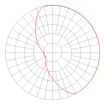 | ||||||||||||||||||
| Azimuth | Ratio | Azimuth | Ratio | Azimuth | Ratio | Azimuth | Ratio | ||||||||||||
| 0 | 1.000 | 10 | 1.000 | 20 | 1.000 | 30 | 1.000 | ||||||||||||
| 40 | 1.000 | 50 | 1.000 | 60 | 1.000 | 70 | 1.000 | ||||||||||||
| 80 | 1.000 | 90 | 1.000 | 100 | 1.000 | 110 | 1.000 | ||||||||||||
| 120 | 1.000 | 130 | 1.000 | 140 | 1.000 | 150 | 1.000 | ||||||||||||
| 160 | 0.885 | 170 | 0.703 | 180 | 0.559 | 190 | 0.444 | ||||||||||||
| 200 | 0.353 | 210 | 0.281 | 220 | 0.224 | 230 | 0.178 | ||||||||||||
| 240 | 0.178 | 250 | 0.178 | 260 | 0.178 | 270 | 0.178 | ||||||||||||
| 280 | 0.224 | 290 | 0.281 | 300 | 0.353 | 310 | 0.445 | ||||||||||||
| 320 | 0.560 | 330 | 0.704 | 340 | 0.886 | 350 | 1.000 | ||||||||||||
Structure Registration Number 1002512 Structure Type: GTOWER Registered To: BOARD OF TRUSTEES OF NORTHERN MICHIGAN UNIVERSITY DBA = WNMU TV FM Structure Address: La Branche La Branche, MI County Name: Menominee County ASR Issued: 09/25/2013 Date Built: 11/11/2013 Site Elevation: 298.7 m (980 ft.) Structure Height: 90.5 m (297 ft.) Height Overall: 91.4 m (300 ft.) Overall Height AMSL: 390.1 m (1280 ft.) FAA Determination: 06/06/2013 FAA Study #: 2013-AGL-4769-OE FAA Circular #: 70/7460-1J Paint & Light FAA Chapters: 3, 4, 5, 13 PRIOR STUDY 1996-AGL-2451-OE 45-53-05.0 N 87-29-19.0 W (NAD 83) 45-53-05.1 N 87-29-18.5 W (Converted to NAD 27) |
Cadillac, MI 49601 Phone: 231-468-2087 Not-for-Profit | Date: 12/13/2013 Application Certifier WEST CENTRAL MICHIGAN MEDIA MINISTRIES P.o. Box 567 Cadillac, MI 49601 Applicant JUSTIN W. ASHER Munn-reese, Inc. Po Box 220, 385 Airport Drive Coldwater, MI 49036-0220 CONSULTING ENGINEER DONALD MARTIN Donald E. Martin, P.c. | |||||||||||||||||