
FCCInfo.com
A Service of Cavell, Mertz & Associates, Inc.
(855) FCC-INFO
|
|
|
|  |
|
|||||||||||||||
|
|
WSMK Channel: 256A 99.1 MHz Buchanan, Michigan Service: FM - A full-service FM station or application. Facility ID: 40167 Fac. Service: FM Status: License 73.215 Station Application Accepted: 08/09/2017 Application Granted: 08/29/2017 File Number: BLH-20170809AAU License Expires: 00/00/0000 Prefix Type: This is a license for a commercial FM station Application Type: License To Cover FCC Website Links: LMS Facility Details This Application CDBS Application Other WSMK Applications Other WSMK Applications in CDBS Including Superseded Applications Mailing Address Correspondence for WSMK Correspondence related to application BLH-20170809AAU Service Contour - Open Street Map or USGS Map (60 dBu) Service Contour - KML / Google Earth (60 dBu) Public Inspection Files Facility Type: FM STATION Class: A, A Zone I; I-A; or II station; with 0.1kW-6kW ERP and a class contour distance <=28km Site Location: 41-49-23.5 N 86-17-02.6 W (NAD 83) Site Location: 41-49-23.3 N 86-17-02.6 W (Converted to NAD 27) Effective Radiated Power: 6 kW Transmitter Output Power: 2.6 kW Antenna Center HAAT: 96.4 m (316 ft.) Antenna Center AMSL: 325.2 m (1067 ft.) Antenna Center HAG: 99 m (325 ft.) Calculated Site Elevation: 226.2 m. (742 ft.) Height Overall*: 102.4 m (336 ft.) (* As Filed In This Application, may differ from ASR Data, Below.) Directional Antenna Antenna Make/Model: Electronics Research Inc. LP-3E-DA, THREE SECTIONS Antenna ID: 121111 Polarization: | ||||||||||||||||||
| Antenna Data for Antenna Id: 121111 WSMK FM File: BLH-20170809AAU Electronics Research Inc. - LP-3E-DA, THREE SECTIONS Service: FM | 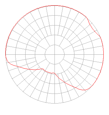 | ||||||||||||||||||
| Azimuth | Ratio | Azimuth | Ratio | Azimuth | Ratio | Azimuth | Ratio | ||||||||||||
| 0 | 1.000 | 10 | 1.000 | 20 | 1.000 | 30 | 1.000 | ||||||||||||
| 40 | 1.000 | 50 | 0.944 | 60 | 0.944 | 70 | 1.000 | ||||||||||||
| 80 | 1.000 | 90 | 1.000 | 100 | 1.000 | 110 | 1.000 | ||||||||||||
| 120 | 1.000 | 130 | 1.000 | 140 | 0.950 | 150 | 0.759 | ||||||||||||
| 160 | 0.606 | 170 | 0.484 | 180 | 0.387 | 190 | 0.387 | ||||||||||||
| 200 | 0.387 | 210 | 0.387 | 220 | 0.387 | 230 | 0.484 | ||||||||||||
| 240 | 0.606 | 250 | 0.759 | 260 | 0.950 | 270 | 1.000 | ||||||||||||
| 280 | 1.000 | 290 | 1.000 | 300 | 1.000 | 310 | 1.000 | ||||||||||||
| 320 | 1.000 | 330 | 1.000 | 340 | 1.000 | 350 | 1.000 | ||||||||||||
Structure Registration Number 1005417 Structure Type: GTOWER Registered To: Tri-Communications, Inc. Structure Address: 210 S Phillip Rd Niles, MI County Name: Berrien County ASR Issued: 06/01/2015 Date Built: 04/01/1981 Site Elevation: 226.2 m (742 ft.) Structure Height: 101.5 m (333 ft.) Height Overall: 102.4 m (336 ft.) Overall Height AMSL: 328.6 m (1078 ft.) FAA Determination: 05/06/2015 FAA Study #: 2015-AGL-3222-OE Paint & Light FAA Chapters: 1, 3, 12, 21 Continue As Is OM&L = PAINT/RED LIGHTS 41-49-23.5 N 86-17-02.6 W (NAD 83) 41-49-23.3 N 86-17-02.6 W (Converted to NAD 27) |
Gary, IN 46402 Phone: 269-683-4343 Individual | Date: 08/09/2017 Application Certifier MARION R. WILLIAMS 2338 Central Drive Gary, IN 46407 Applicant R. STUART GRAHAM Graham Brock, Inc. P. O. Box 24466 St. Simons Island, GA 31522-7466 TECHNICAL CONSULTANT ALLAN G. MOSKOWITZ, ESQ. Allan G. Moskowitz, Esq. | |||||||||||||||||