
FCCInfo.com
A Service of Cavell, Mertz & Associates, Inc.
(855) FCC-INFO
|
|
WWGO from 03/17/1993 WWGO from 12/18/1979 |
|  |
|
||||||||||||||||||
|
|
WWGO Channel: 221A 92.1 MHz Charleston, Illinois Service: FM - A full-service FM station or application. Facility ID: 72317 Fac. Service: FM Status: License 73.215 Station Application Accepted: 04/18/2002 Application Granted: 05/24/2002 File Number: BLH-20020418ABC License Expires: 00/00/0000 Prefix Type: This is a license for a commercial FM station Application Type: Amendment FCC Website Links: LMS Facility Details This Application CDBS Application Other WWGO Applications Other WWGO Applications in CDBS Including Superseded Applications Mailing Address Correspondence for WWGO Correspondence related to application BLH-20020418ABC Service Contour - Open Street Map or USGS Map (60 dBu) Service Contour - KML / Google Earth (60 dBu) Public Inspection Files History Cards for WWGO Facility Type: FM STATION Class: A, A Zone I; I-A; or II station; with 0.1kW-6kW ERP and a class contour distance <=28km Site Location: 39-31-40.1 N 88-21-23.2 W (NAD 83) Site Location: 39-31-40.0 N 88-21-23.0 W (Converted to NAD 27) Effective Radiated Power: 6 kW Transmitter Output Power: 2.37 kW Antenna Center HAAT: 100 m (328 ft.) Antenna Center AMSL: 305 m (1001 ft.) Antenna Center HAG: 93 m (305 ft.) Site Elevation: 212 m. (696 ft.) Height Overall*: 98 m (322 ft.) (* As Filed In This Application, may differ from ASR Data, Below.) Directional Antenna Antenna Make/Model: Shivley 6810-3R-DA Antenna ID: 41972 Polarization:
| |||||||||||||||||||||
| Antenna Data for Antenna Id: 41972 WWGO FM File: BLH-20020418ABC Shivley - 6810-3R-DA Service: FM | 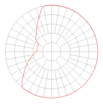 | |||||||||||||||||||||
| Azimuth | Ratio | Azimuth | Ratio | Azimuth | Ratio | Azimuth | Ratio | |||||||||||||||
| 0 | 1.000 | 10 | 1.000 | 20 | 1.000 | 30 | 1.000 | |||||||||||||||
| 40 | 1.000 | 50 | 1.000 | 60 | 1.000 | 70 | 1.000 | |||||||||||||||
| 80 | 1.000 | 90 | 1.000 | 100 | 1.000 | 110 | 1.000 | |||||||||||||||
| 120 | 1.000 | 130 | 1.000 | 140 | 1.000 | 150 | 1.000 | |||||||||||||||
| 160 | 1.000 | 170 | 1.000 | 180 | 1.000 | 190 | 1.000 | |||||||||||||||
| 200 | 1.000 | 210 | 1.000 | 220 | 0.985 | 230 | 0.785 | |||||||||||||||
| 240 | 0.641 | 250 | 0.500 | 260 | 0.400 | 270 | 0.320 | |||||||||||||||
| 280 | 0.320 | 290 | 0.320 | 300 | 0.320 | 310 | 0.450 | |||||||||||||||
| 320 | 0.500 | 330 | 0.625 | 340 | 0.785 | 350 | 0.985 | |||||||||||||||
Structure Registration Number 1057129 Structure Type: TOWER Registered To: THE CROMWELL GROUP, INC. OF ILLINOIS Structure Address: 2.42 Miles N.e. Mattoon, IL County Name: Coles County ASR Issued: 03/14/2017 Date Built: 11/01/1993 Site Elevation: 212 m (696 ft.) Structure Height: 97 m (318 ft.) Height Overall: 98 m (322 ft.) Overall Height AMSL: 310 m (1017 ft.) FAA Determination: 08/28/1998 FAA Study #: 98-AGL-3510-OE FAA Circular #: 70/7460-1G Paint & Light FAA Chapters: 3, 4, 5, 9 39-31-40.0 N 88-21-23.0 W (NAD 83) 39-31-39.9 N 88-21-22.8 W (Converted to NAD 27) |
P.o. Box 150846 Nashville, TN 37215 Phone: 202-857-4455 | Date: 04/18/2002 Application Certifier WHQQ, INC. P.o. Box 150846 Nashville, TN 37215-0846 Applicant CHARLES M. ANDERSON 1429 River Ro Drive Tuscaloosa, AL 35406 CONSULTING ENGINEER JOHN F. GARZIGLIA, ESQ. Womble Carlyle Sandridge & Rice, Pllc | ||||||||||||||||||||
|
| |||||||||||||||||||||