
FCCInfo.com
A Service of Cavell, Mertz & Associates, Inc.
(855) FCC-INFO
|
|
|
|  |
|
|||||||||||||||
|
|
WHTO Channel: 294C3 106.7 MHz Iron Mountain, Michigan Service: FM - A full-service FM station or application. Facility ID: 78163 Fac. Service: FM Status: License 73.215 Station Application Accepted: 07/13/2016 Application Granted: 07/18/2016 File Number: BMLH-20160713ABP License Expires: 00/00/0000 Prefix Type: This is a modification of a license for a commecial FM station Application Type: Minor Modification FCC Website Links: LMS Facility Details This Application CDBS Application Other WHTO Applications Other WHTO Applications in CDBS Including Superseded Applications Mailing Address Correspondence for WHTO Correspondence related to application BMLH-20160713ABP Service Contour - Open Street Map or USGS Map (60 dBu) Service Contour - KML / Google Earth (60 dBu) Public Inspection Files Facility Type: FM STATION Class: C3, A Zone II station; with 6kW-25kW ERP and a class contour distance 28km-39km Site Location: 45-49-14.8 N 88-02-36.5 W (NAD 83) Site Location: 45-49-15.0 N 88-02-36.0 W (Converted to NAD 27) Effective Radiated Power: 6.1 kW Transmitter Output Power: 9.74 kW Antenna Center HAAT: 206 m (676 ft.) Antenna Center AMSL: 548 m (1798 ft.) Antenna Center HAG: 69 m (226 ft.) Calculated Site Elevation: 479 m. (1572 ft.) Height Overall*: 74 m (243 ft.) (* As Filed In This Application, may differ from ASR Data, Below.) Directional Antenna Antenna Make/Model: Shivley 6810-1R-DA Antenna ID: 73137 Polarization: | ||||||||||||||||||
| Antenna Data for Antenna Id: 73137 WHTO FM File: BMLH-20160713ABP Shivley - 6810-1R-DA Service: FM | 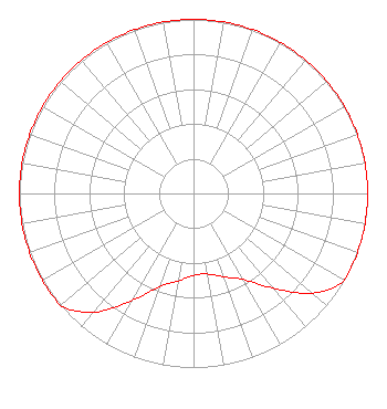 | ||||||||||||||||||
| Azimuth | Ratio | Azimuth | Ratio | Azimuth | Ratio | Azimuth | Ratio | ||||||||||||
| 0 | 1.000 | 10 | 1.000 | 20 | 1.000 | 30 | 1.000 | ||||||||||||
| 40 | 1.000 | 50 | 1.000 | 60 | 1.000 | 70 | 1.000 | ||||||||||||
| 80 | 1.000 | 90 | 1.000 | 100 | 1.000 | 110 | 1.000 | ||||||||||||
| 120 | 1.000 | 130 | 0.890 | 140 | 0.710 | 150 | 0.570 | ||||||||||||
| 160 | 0.510 | 170 | 0.470 | 180 | 0.470 | 190 | 0.510 | ||||||||||||
| 200 | 0.570 | 210 | 0.710 | 220 | 0.890 | 230 | 1.000 | ||||||||||||
| 240 | 1.000 | 250 | 1.000 | 260 | 1.000 | 270 | 1.000 | ||||||||||||
| 280 | 1.000 | 290 | 1.000 | 300 | 1.000 | 310 | 1.000 | ||||||||||||
| 320 | 1.000 | 330 | 1.000 | 340 | 1.000 | 350 | 1.000 | ||||||||||||
Structure Registration Number 1008111 [ASR Heights Differ from WHTO Application] Structure Type: GTOWER Registered To: Results Broadcasting of Iron Mountain, Inc. Structure Address: Millie Hill Iron Mountain, MI County Name: Dickinson County ASR Issued: 07/12/2019 Date Built: 01/01/1963 Site Elevation: 478.2 m (1569 ft.) Structure Height: 70.1 m (230 ft.) Height Overall: 74.4 m (244 ft.) Overall Height AMSL: 552.6 m (1813 ft.) FAA Determination: 11/04/2015 FAA Study #: 2015-AGL-11158-OE FAA Circular #: 70/7460-1J Paint & Light FAA Chapters: 3, 4, 5, 13 PRIOR STUDY 1997-AGL-5-OE 45-49-15.3 N 88-02-36.2 W (NAD 83) 45-49-15.5 N 88-02-35.7 W (Converted to NAD 27) |
P.o. Box 456 Shawano, WI 54166 Phone: 715-524-2194 | Date: 07/13/2016 Application Certifier RESULTS BROADCASTING OF IRON MOUNTAIN, INC. 1456 East Green Bay Street Shawano, WI 54166 Applicant DAVID J DOHERTY Skywaves Consulting Llc Po Box 4 Millbury, MA 01527-0004 TECHNICAL CONSULTANT JOHN F. GARZIGLIA, ESQ. Womble Carlyle Sandridge & Rice, Llp | |||||||||||||||||
| |||||||||||||||||||