
FCCInfo.com
A Service of Cavell, Mertz & Associates, Inc.
(855) FCC-INFO
|
|
W271CU from 01/08/2014 |
|
|
||||||||||||||||
|
|
W271CU Channel: 271D 102.1 MHz Framingham, Massachusetts Service: FX - A translator or application for a translator. Facility ID: 142849 Fac. Service: FX Programming Delivery Method: Unspecified Status: License Application Accepted: 08/22/2016 Application Granted: 09/12/2016 File Number: BLFT-20160822AAV License Expires: 00/00/0000 Prefix Type: This is a license for a translator Application Type: License To Cover FCC Website Links: LMS Facility Details This Application CDBS Application Other W271CU Applications Other W271CU Applications in CDBS Including Superseded Applications Mailing Address Correspondence for W271CU Correspondence related to application BLFT-20160822AAV Service Contour - Open Street Map or USGS Map (60 dBu) Service Contour - KML / Google Earth (60 dBu) Class: D, A Noncommercial educational operating with no more than 10W Site Location: 42-17-18.3 N 71-25-51.2 W (NAD 83) Site Location: 42-17-18.0 N 71-25-53.0 W (Converted to NAD 27) Effective Radiated Power: 0.04 kW Transmitter Output Power: 0.046 kW Antenna Center HAAT: 0 m Antenna Center AMSL: 179 m (587 ft.) Antenna Center HAG: 130 m (427 ft.) Site Elevation: 49 m. (161 ft.) Height Overall*: 137 m (449 ft.) (* As Filed In This Application, may differ from ASR Data, Below.) Directional Antenna Antenna Make/Model: None Antenna ID: 124234 Polarization:
| ||||||||||||||||||
| Antenna Data for Antenna Id: 124234 W271CU FX File: BLFT-20160822AAV None - Service: FX | 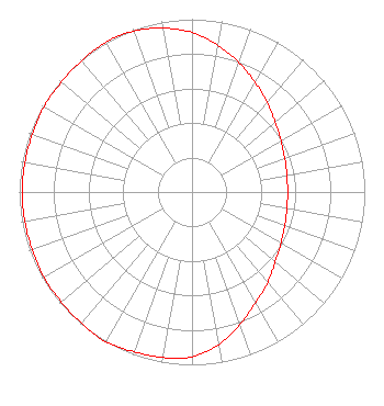 | ||||||||||||||||||
| Azimuth | Ratio | Azimuth | Ratio | Azimuth | Ratio | Azimuth | Ratio | ||||||||||||
| 0 | 0.923 | 10 | 0.862 | 20 | 0.797 | 30 | 0.731 | ||||||||||||
| 40 | 0.676 | 50 | 0.628 | 60 | 0.594 | 70 | 0.571 | ||||||||||||
| 80 | 0.558 | 90 | 0.553 | 100 | 0.558 | 110 | 0.571 | ||||||||||||
| 120 | 0.594 | 130 | 0.628 | 140 | 0.682 | 150 | 0.738 | ||||||||||||
| 160 | 0.815 | 170 | 0.897 | 180 | 0.953 | 190 | 0.973 | ||||||||||||
| 200 | 0.983 | 210 | 1.000 | 220 | 0.992 | 230 | 0.988 | ||||||||||||
| 240 | 0.988 | 250 | 0.983 | 260 | 0.983 | 270 | 0.983 | ||||||||||||
| 280 | 0.983 | 290 | 0.983 | 300 | 0.988 | 310 | 0.988 | ||||||||||||
| 320 | 0.992 | 330 | 1.000 | 340 | 0.991 | 350 | 0.963 | ||||||||||||
Structure Registration Number 1006700 Structure Type: 2TA2 Registered To: 100 Mt. Wayte Avenue LLC Structure Address: Twr 2 - 100 Mount Wayte Avenue Framingham, MA County Name: Middlesex County ASR Issued: 05/11/2011 Date Built: 05/01/1998 Site Elevation: 49.3 m (162 ft.) Structure Height: 135.6 m (445 ft.) Height Overall: 137.2 m (450 ft.) Overall Height AMSL: 186.5 m (612 ft.) FAA Determination: 10/23/1980 FAA Study #: 80-ANE-220-OE Paint & Light FAA Chapters: 1, 3, 12, 21 RED LIGHTS/PAINT 42-17-18.0 N 71-25-51.0 W (NAD 83) 42-17-17.7 N 71-25-52.8 W (Converted to NAD 27) |
94 St. Rose Street Boston, MA 02130 Phone: 301-908-4165 Limited Liability Company | Date: 08/22/2016 Application Certifier LANGER BROADCASTING GROUP, LLC 94 St. Rose Street Boston, MA 02130 Applicant CHARLES A. HECHT Charles A. Hecht & Associates, Inc. 19 Mackenzie Court Freehold, NJ 07728 CHARLES A. HECHT ALLAN G. MOSKOWITZ, ESQ. Allan G. Moskowitz, Esq. 10845 Tuckahoe Way North Potomac, MD 20878 | |||||||||||||||||