
FCCInfo.com
A Service of Cavell, Mertz & Associates, Inc.
(855) FCC-INFO
|
|
|
|  |
|
|||||||||||||||||||||
|
|
WXCC Channel: 243C1 96.5 MHz Williamson, West Virginia Service: FM - A full-service FM station or application. Facility ID: 26393 Fac. Service: FM Status: License 73.215 Station Application Accepted: 12/05/2007 Application Granted: 12/14/2007 File Number: BLH-20071205ABF License Expires: 00/00/0000 Prefix Type: This is a license for a commercial FM station Application Type: License To Cover FCC Website Links: LMS Facility Details This Application CDBS Application Other WXCC Applications Other WXCC Applications in CDBS Including Superseded Applications Mailing Address Correspondence for WXCC Correspondence related to application BLH-20071205ABF Service Contour - Open Street Map or USGS Map (60 dBu) Service Contour - KML / Google Earth (60 dBu) Public Inspection Files History Cards for WXCC Facility Type: FM STATION Class: C1, A Zone II station; with 50kW-100kW ERP and a class contour distance 52km-72km Site Location: 37-30-48.4 N 82-15-19.5 W (NAD 83) Site Location: 37-30-48.0 N 82-15-20.0 W (Converted to NAD 27) Effective Radiated Power: 75 kW Transmitter Output Power: 16.7 kW Antenna Center HAAT: 339 m (1112 ft.) Antenna Center AMSL: 759 m (2490 ft.) Antenna Center HAG: 80 m (262 ft.) Calculated Site Elevation: 679 m. (2228 ft.) Height Overall*: 98 m (322 ft.) (* As Filed In This Application, may differ from ASR Data, Below.) Directional Antenna Antenna Make/Model: Propagation System Inc FHR-6C-DA, six sections Antenna ID: 79549 Polarization: | ||||||||||||||||||||||||
| Antenna Data for Antenna Id: 79549 WXCC FM File: BLH-20071205ABF Propagation System Inc - FHR-6C-DA, six sections Service: FM | 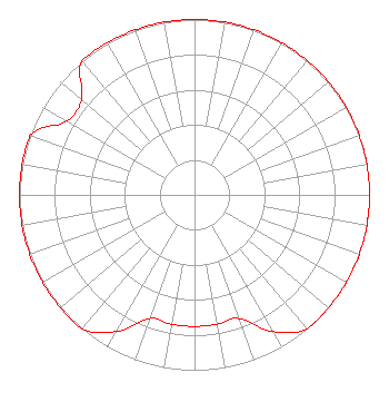 | ||||||||||||||||||||||||
| Azimuth | Ratio | Azimuth | Ratio | Azimuth | Ratio | Azimuth | Ratio | ||||||||||||||||||
| 0 | 1.000 | 10 | 1.000 | 20 | 1.000 | 30 | 1.000 | ||||||||||||||||||
| 40 | 1.000 | 50 | 1.000 | 60 | 1.000 | 70 | 1.000 | ||||||||||||||||||
| 80 | 1.000 | 90 | 1.000 | 100 | 1.000 | 110 | 1.000 | ||||||||||||||||||
| 120 | 1.000 | 130 | 1.000 | 140 | 1.000 | 150 | 0.900 | ||||||||||||||||||
| 160 | 0.750 | 170 | 0.750 | 180 | 0.750 | 190 | 0.750 | ||||||||||||||||||
| 200 | 0.750 | 210 | 0.900 | 220 | 1.000 | 230 | 1.000 | ||||||||||||||||||
| 240 | 1.000 | 250 | 1.000 | 260 | 1.000 | 270 | 1.000 | ||||||||||||||||||
| 280 | 1.000 | 290 | 1.000 | 300 | 0.843 | 310 | 0.843 | ||||||||||||||||||
| 320 | 1.000 | 330 | 1.000 | 340 | 1.000 | 350 | 1.000 | ||||||||||||||||||
Structure Registration Number 1255667 [ASR Heights Differ from WXCC Application] Structure Type: TOWER Registered To: East Kentucky Network, LLC d/b/a Appalachian Wireless Structure Address: 2.0 Km South Of Mcveigh, KY County Name: Pike County ASR Issued: 01/17/2023 Date Built: 04/18/2007 Site Elevation: 679.4 m (2229 ft.) Structure Height: 91.4 m (300 ft.) Height Overall: 97.5 m (320 ft.) Overall Height AMSL: 776.9 m (2549 ft.) FAA Determination: 06/22/2006 FAA Study #: 2006-ASO-3293-OE FAA Circular #: 70/7460-1K Paint & Light FAA Chapters: 4, 8, 12 Removed expiration date from determination. Scenario 1./jjs/case#635066 37-30-48.2 N 82-15-19.4 W (NAD 83) 37-30-47.8 N 82-15-19.9 W (Converted to NAD 27) |
P.o. Box 2040 Pikeville, KY 41502 Phone: 606-437-4051 Limited Liability Company | Date: 12/05/2007 Application Certifier EAST KENTUCKY RADIO NETWORK, INC. Po Box 2200 Pikeville, KY 41502 Applicant PETER L. BOYCE Midamerica Electronics Service, Inc. 410 Mount Tabor Road New Albany, IN 47150 ENGINEER JOHN F. GARZIGLIA Womble Carlyle Sandridge & Rice, Pllc | |||||||||||||||||||||||
| |||||||||||||||||||||||||