
FCCInfo.com
A Service of Cavell, Mertz & Associates, Inc.
(855) FCC-INFO
|
|
|
|  |
|
|||||||||||||||
|
|
WFAE Channel: 214C0 90.7 MHz Charlotte, North Carolina Service: FM - A full-service FM station or application. Facility ID: 69436 Fac. Service: FM Status: License Application Accepted: 02/23/2005 Application Granted: 04/05/2005 File Number: BLED-20050223ACA License Expires: 00/00/0000 Prefix Type: This is a license for a noncommercial educational FM station Application Type: Amendment FCC Website Links: LMS Facility Details This Application CDBS Application Other WFAE Applications Other WFAE Applications in CDBS Including Superseded Applications Mailing Address Correspondence for WFAE Correspondence related to application BLED-20050223ACA Service Contour - Open Street Map or USGS Map (60 dBu) Service Contour - KML / Google Earth (60 dBu) Public Inspection Files History Cards for WFAE Facility Type: NON-COMMERCIAL EDUC. FM Class: C0, C0 Site Location: 35-17-14.5 N 80-41-44.2 W (NAD 83) Site Location: 35-17-14.0 N 80-41-45.0 W (Converted to NAD 27) Effective Radiated Power: 100 kW Transmitter Output Power: 30.7 kW Antenna Center HAAT: 331 m (1086 ft.) Antenna Center AMSL: 544 m (1785 ft.) Antenna Center HAG: 326 m (1070 ft.) Site Elevation: 218 m. (715 ft.) Height Overall*: 380 m (1247 ft.) (* As Filed In This Application, may differ from ASR Data, Below.) Directional Antenna Antenna Make/Model: DIELECTRIC DCBR-C3SP-5FM/13H-1-N Antenna ID: 67579 Polarization:
| ||||||||||||||||||
| Antenna Data for Antenna Id: 67579 WFAE FM File: BLED-20050223ACA DIELECTRIC - DCBR-C3SP-5FM/13H-1-N Service: FM | 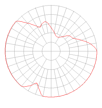 | ||||||||||||||||||
| Azimuth | Ratio | Azimuth | Ratio | Azimuth | Ratio | Azimuth | Ratio | ||||||||||||
| 0 | 0.513 | 10 | 0.408 | 20 | 0.340 | 30 | 0.350 | ||||||||||||
| 40 | 0.410 | 50 | 0.516 | 60 | 0.560 | 70 | 0.700 | ||||||||||||
| 80 | 0.880 | 90 | 1.000 | 100 | 1.000 | 110 | 1.000 | ||||||||||||
| 120 | 1.000 | 130 | 1.000 | 140 | 1.000 | 150 | 1.000 | ||||||||||||
| 160 | 1.000 | 170 | 1.000 | 180 | 1.000 | 190 | 1.000 | ||||||||||||
| 200 | 0.829 | 203 | 0.774 | 204 | 0.767 | 205 | 0.774 | ||||||||||||
| 210 | 0.868 | 220 | 1.000 | 230 | 1.000 | 240 | 1.000 | ||||||||||||
| 250 | 1.000 | 260 | 1.000 | 270 | 1.000 | 280 | 1.000 | ||||||||||||
| 290 | 1.000 | 300 | 1.000 | 310 | 1.000 | 320 | 0.795 | ||||||||||||
| 330 | 0.632 | 334 | 0.580 | 337 | 0.580 | 340 | 0.618 | ||||||||||||
| 350 | 0.645 | ||||||||||||||||||
Structure Registration Number 1005065 Structure Type: TOWER Registered To: Central Piedmont Community College Structure Address: 12541 Caldwell Rd Charlotte, NC County Name: Mecklenburg County ASR Issued: 04/04/2022 Date Built: 08/01/1992 Site Elevation: 218 m (715 ft.) Structure Height: 365 m (1198 ft.) Height Overall: 380 m (1247 ft.) Overall Height AMSL: 598 m (1962 ft.) FAA Determination: 05/08/1991 FAA Study #: 90-ASO-2460-OE FAA Circular #: 70/7460-1G Paint & Light FAA Chapters: 3, 4, 5, 9 RED LIGHTS/PAINT 35-17-15.0 N 80-41-44.0 W (NAD 83) 35-17-14.5 N 80-41-44.8 W (Converted to NAD 27) |
8801 Jm Keynes Drive Suite 91 Charlotte, NC 28262 Phone: 704-549-9323 Not-for-Profit | Date: 02/23/2005 Application Certifier UNIVERSITY RADIO FOUNDATION, INC 8801 Jm Keynes Drive Suite 91 Charlotte, NC 28262 Applicant TIMOTHY L. WARNER, P.E. Timothy L. Warner, Inc. Post Office Box 8045 Asheville, NC 28814-8045 TECHNICAL CONSULTANT UNIVERSITY RADIO FOUNDATION, INC University Radio Foundation, Inc | |||||||||||||||||
|
| ||||||||||||||||||