
FCCInfo.com
A Service of Cavell, Mertz & Associates, Inc.
(855) FCC-INFO
|
|
WKKN from 03/31/1997 WKKN from 08/01/1988 WKKN from 11/22/1978 |
|  |
|
||||||||||||||||||||||||
|
|
WKKN Channel: 270A 101.9 MHz Westminster, Vermont Service: FM - A full-service FM station or application. Facility ID: 46334 Fac. Service: FM Status: License 73.215 Station Application Accepted: 04/09/2008 Application Granted: 04/15/2008 File Number: BLH-20080409AAH License Expires: 00/00/0000 Prefix Type: This is a license for a commercial FM station Application Type: License To Cover FCC Website Links: LMS Facility Details This Application CDBS Application Other WKKN Applications Other WKKN Applications in CDBS Including Superseded Applications Mailing Address Correspondence for WKKN Correspondence related to application BLH-20080409AAH Service Contour - Open Street Map or USGS Map (60 dBu) Service Contour - KML / Google Earth (60 dBu) Public Inspection Files History Cards for WKKN Facility Type: FM STATION Class: A, A Zone I; I-A; or II station; with 0.1kW-6kW ERP and a class contour distance <=28km Site Location: 43-02-00.3 N 72-22-02.0 W (NAD 83) Site Location: 43-02-00.0 N 72-22-03.7 W (Converted to NAD 27) Effective Radiated Power: 1.05 kW Transmitter Output Power: 1.45 kW Antenna Center HAAT: 236 m (774 ft.) Antenna Center AMSL: 511 m (1677 ft.) Antenna Center HAG: 49 m (161 ft.) Calculated Site Elevation: 462 m. (1516 ft.) Height Overall*: 152.4 m (500 ft.) (* As Filed In This Application, may differ from ASR Data, Below.) Directional Antenna Antenna Make/Model: Shivley 6810-1R-DA Antenna ID: 77306 Polarization: | |||||||||||||||||||||||||||
| Antenna Data for Antenna Id: 77306 WKKN FM File: BLH-20080409AAH Shivley - 6810-1R-DA Service: FM | 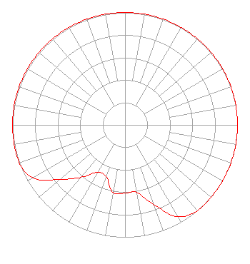 | |||||||||||||||||||||||||||
| Azimuth | Ratio | Azimuth | Ratio | Azimuth | Ratio | Azimuth | Ratio | |||||||||||||||||||||
| 0 | 1.000 | 10 | 1.000 | 20 | 1.000 | 30 | 1.000 | |||||||||||||||||||||
| 40 | 1.000 | 50 | 1.000 | 60 | 1.000 | 70 | 1.000 | |||||||||||||||||||||
| 80 | 1.000 | 90 | 1.000 | 100 | 1.000 | 110 | 1.000 | |||||||||||||||||||||
| 120 | 1.000 | 130 | 1.000 | 140 | 1.000 | 150 | 0.944 | |||||||||||||||||||||
| 160 | 0.758 | 170 | 0.609 | 180 | 0.609 | 190 | 0.609 | |||||||||||||||||||||
| 200 | 0.489 | 210 | 0.489 | 220 | 0.609 | 230 | 0.758 | |||||||||||||||||||||
| 240 | 0.944 | 250 | 1.000 | 260 | 1.000 | 270 | 1.000 | |||||||||||||||||||||
| 280 | 1.000 | 290 | 1.000 | 300 | 1.000 | 310 | 1.000 | |||||||||||||||||||||
| 320 | 1.000 | 330 | 1.000 | 340 | 1.000 | 350 | 1.000 | |||||||||||||||||||||
Structure Registration Number 1034694 Structure Type: TOWER Registered To: New Hampshire Public Broadcasting Structure Address: On Derry Hill 8 Mi Nnw Of Keene Nh Walpole, NH County Name: Cheshire County ASR Issued: 04/08/2021 Date Built: 01/01/1967 Site Elevation: 462.4 m (1517 ft.) Structure Height: 138.7 m (455 ft.) Height Overall: 152.4 m (500 ft.) Overall Height AMSL: 614.8 m (2017 ft.) FAA Determination: 05/27/1997 FAA Study #: 97-ANE-0169-OE Paint & Light FAA Chapters: 1, 3, 4, 13, 21 43-02-00.0 N 72-22-02.0 W (NAD 83) 43-01-59.7 N 72-22-03.7 W (Converted to NAD 27) |
106 North Main Street West Lebanon, NH 03766 Phone: 603-359-7110 Limited Liability Company | Date: 04/09/2008 Application Certifier GREAT EASTERN RADIO, LLC 35 South Main Street Suite 300 Hanover, NH 03755 Applicant ROBERT M. SMITH JR. R.m. Smith Associates 4267 Nw Federal Highway #120 Jensen Beach, FL 34957 TECHNICAL CONSULTANT DAVID G. O'NEIL, ESQ. Rini Coran, Pc | ||||||||||||||||||||||||||
|
| |||||||||||||||||||||||||||