
FCCInfo.com
A Service of Cavell, Mertz & Associates, Inc.
(855) FCC-INFO
|
|
K267BJ from 06/24/1987 |
|
|
||||||||||||||||
|
|
K267BJ Channel: 267D 101.3 MHz Ferndale, Etc., Montana Service: FX - A translator or application for a translator. Facility ID: 64280 Fac. Service: FX Programming Delivery Method: Unspecified Status: License Application Accepted: 01/27/2010 Application Granted: 02/05/2010 File Number: BLFT-20100127ABV License Expires: 00/00/0000 Prefix Type: This is a license for a translator Application Type: License To Cover FCC Website Links: LMS Facility Details This Application CDBS Application Other K267BJ Applications Other K267BJ Applications in CDBS Including Superseded Applications Mailing Address Correspondence for K267BJ Correspondence related to application BLFT-20100127ABV Service Contour - Open Street Map or USGS Map (60 dBu) Service Contour - KML / Google Earth (60 dBu) Class: D, A Noncommercial educational operating with no more than 10W Site Location: 48-04-04.3 N 114-02-19.3 W (NAD 83) Site Location: 48-04-04.5 N 114-02-15.9 W (Converted to NAD 27) Effective Radiated Power: 0.048 kW Horiz. ; 0 kW Vert. Transmitter Output Power: 0.025 kW Antenna Center HAAT: 60.2 m Horiz.; 0 m Vert. Antenna Center AMSL: 1149 m Horiz.; 0 m Vert. Antenna Center HAG: 18 m Horiz.; 0 m Vert. Site Elevation: 1131 m. (3711 ft.) Height Overall*: 33 m (108 ft.) (* As Filed In This Application, may differ from ASR Data, Below.) Directional Antenna Antenna Make/Model: None Antenna ID: 96245 Polarization:
| ||||||||||||||||||
| Antenna Data for Antenna Id: 96245 K267BJ FX File: BLFT-20100127ABV None - Service: FX | 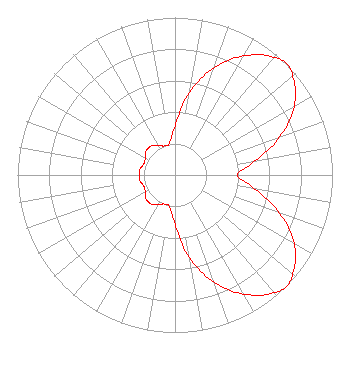 | ||||||||||||||||||
| Azimuth | Ratio | Azimuth | Ratio | Azimuth | Ratio | Azimuth | Ratio | ||||||||||||
| 0 | 0.312 | 10 | 0.535 | 20 | 0.724 | 30 | 0.874 | ||||||||||||
| 40 | 0.975 | 45 | 1.000 | 50 | 0.975 | 60 | 0.874 | ||||||||||||
| 70 | 0.709 | 80 | 0.515 | 90 | 0.396 | 100 | 0.515 | ||||||||||||
| 110 | 0.709 | 120 | 0.874 | 130 | 0.975 | 135 | 1.000 | ||||||||||||
| 140 | 0.975 | 150 | 0.874 | 160 | 0.724 | 170 | 0.535 | ||||||||||||
| 180 | 0.312 | 190 | 0.205 | 200 | 0.196 | 210 | 0.217 | ||||||||||||
| 220 | 0.239 | 230 | 0.239 | 240 | 0.217 | 250 | 0.210 | ||||||||||||
| 260 | 0.225 | 270 | 0.228 | 280 | 0.225 | 290 | 0.210 | ||||||||||||
| 300 | 0.217 | 310 | 0.239 | 320 | 0.239 | 330 | 0.217 | ||||||||||||
| 340 | 0.196 | 350 | 0.205 | ||||||||||||||||
Structure Registration Number 1253697 Structure Type: TOWER Registered To: Swan Hill TV District Structure Address: Swan Hill Communications Site Bigfork, MT County Name: Flathead County ASR Issued: 03/09/2010 Site Elevation: 1130.8 m (3710 ft.) Structure Height: 32.9 m (108 ft.) Height Overall: 32.9 m (108 ft.) Overall Height AMSL: 1163.7 m (3818 ft.) FAA Determination: 05/08/2006 FAA Study #: 2006-ANM-771-OE Paint & Light FAA Chapters: NONE 48-04-04.3 N 114-02-19.3 W (NAD 83) 48-04-04.5 N 114-02-15.9 W (Converted to NAD 27) |
P.o. Box 530 Big Fork, MT 59911 Phone: 406-837-1514 | Date: 01/27/2010 Application Certifier SWAN HILL TV DISTRICT P.o. Box 530 Big Fork, MT 59911 Applicant CHARLIE CANNALIATO 200 Evans Avenue Missoula, MT 59801-5831 CONSULTING ENGINEER RUSSELL PICKETT Swan Hill Tv District Po Box 530 Big Fork, MT 59911 | |||||||||||||||||