
FCCInfo.com
A Service of Cavell, Mertz & Associates, Inc.
(855) FCC-INFO
|
|
W224CA from 11/06/2006 W224CA from 05/17/2004 |
|
|
||||||||||||||||
|
|
W224CA Channel: 224D 92.7 MHz Ludington, Michigan Service: FX - A translator or application for a translator. Facility ID: 145382 Fac. Service: FX Programming Delivery Method: Unspecified Status: License Application Accepted: 07/02/2015 Application Granted: 07/20/2015 File Number: BLFT-20150702AAP License Expires: 00/00/0000 Prefix Type: This is a license for a translator Application Type: License To Cover FCC Website Links: LMS Facility Details This Application CDBS Application Other W224CA Applications Other W224CA Applications in CDBS Including Superseded Applications Mailing Address Correspondence for W224CA Correspondence related to application BLFT-20150702AAP Service Contour - Open Street Map or USGS Map (60 dBu) Service Contour - KML / Google Earth (60 dBu) Class: D, A Noncommercial educational operating with no more than 10W Site Location: 43-55-01.0 N 86-26-12.3 W (NAD 83) Site Location: 43-55-01.0 N 86-26-12.0 W (Converted to NAD 27) Effective Radiated Power: 0.16 kW Transmitter Output Power: 0.4 kW Antenna Center HAAT: 0 m Antenna Center AMSL: 295 m (968 ft.) Antenna Center HAG: 55 m (180 ft.) Site Elevation: 240 m. (787 ft.) Height Overall*: 60 m (197 ft.) (* As Filed In This Application, may differ from ASR Data, Below.) Directional Antenna Antenna Make/Model: None Antenna ID: 121060 Polarization:
| ||||||||||||||||||
| Antenna Data for Antenna Id: 121060 W224CA FX File: BLFT-20150702AAP None - Service: FX Pattern and Field Values Include a 330° Clockwise Rotation | 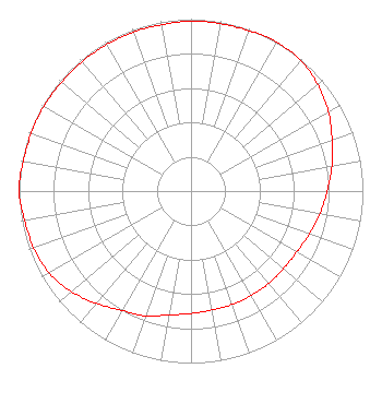 | ||||||||||||||||||
| Azimuth | Ratio | Azimuth | Ratio | Azimuth | Ratio | Azimuth | Ratio | ||||||||||||
| 0 | 0.988 | 10 | 0.988 | 20 | 0.992 | 30 | 1.000 | ||||||||||||
| 40 | 0.991 | 50 | 0.963 | 60 | 0.923 | 70 | 0.873 | ||||||||||||
| 80 | 0.832 | 90 | 0.792 | 100 | 0.762 | 110 | 0.732 | ||||||||||||
| 120 | 0.710 | 130 | 0.702 | 140 | 0.702 | 150 | 0.702 | ||||||||||||
| 160 | 0.702 | 170 | 0.702 | 180 | 0.712 | 190 | 0.732 | ||||||||||||
| 200 | 0.772 | 210 | 0.802 | 220 | 0.853 | 230 | 0.909 | ||||||||||||
| 240 | 0.953 | 250 | 0.973 | 260 | 0.983 | 270 | 1.000 | ||||||||||||
| 280 | 0.992 | 290 | 0.988 | 300 | 0.988 | 310 | 0.983 | ||||||||||||
| 320 | 0.983 | 330 | 0.983 | 340 | 0.983 | 350 | 0.983 | ||||||||||||
Structure Registration Number 1261248 Structure Type: TOWER Registered To: Mason County, Michigan Structure Address: Nw Of Intersection Of Inman And Bradshaw Roads, Mason Co., Mi Ludington, MI County Name: Mason County ASR Issued: 01/17/2008 Date Built: 01/17/2008 Site Elevation: 239.8 m (787 ft.) Structure Height: 60.3 m (198 ft.) Height Overall: 60.3 m (198 ft.) Overall Height AMSL: 300.1 m (985 ft.) FAA Determination: 12/03/2007 FAA Study #: 2007-AGL-8590-OE Paint & Light FAA Chapters: NONE 43-55-01.0 N 86-26-12.0 W (NAD 83) 43-55-01.0 N 86-26-11.7 W (Converted to NAD 27) |
5941 West Us 10 Ludington, MI 49431 Phone: 231-843-0941 | Date: 07/02/2015 Application Certifier SYNERGY LAKESHORE LICENSES, LLC Po Box 855 Ludington, MI 49431 Applicant TODD MOHR 5399 Wallace Lane Ludington, MI 49431 MEMBER DAVID OXENFORD Wilkinson Barker Knauer, Llp 2300 N Street, N.w. Suite 700 Washington, DC 20037-1128 | |||||||||||||||||