
FCCInfo.com
A Service of Cavell, Mertz & Associates, Inc.
(855) FCC-INFO
|
|
|
|
|
||||||||||||||||
|
|
WHSF Channel: 210C2 89.9 MHz Rhinelander, Wisconsin Service: FM - A full-service FM station or application. Facility ID: 172402 Fac. Service: FM Status: License Application Accepted: 03/01/2013 Application Granted: 03/19/2013 File Number: BLED-20130301AGM License Expires: 00/00/0000 Prefix Type: This is a license for a noncommercial educational FM station Application Type: License To Cover FCC Website Links: LMS Facility Details This Application CDBS Application Other WHSF Applications Other WHSF Applications in CDBS Including Superseded Applications Mailing Address Correspondence for WHSF Correspondence related to application BLED-20130301AGM Service Contour - Open Street Map or USGS Map (60 dBu) Service Contour - KML / Google Earth (60 dBu) Public Inspection Files Facility Type: NON-COMMERCIAL EDUC. FM Class: C2, A Zone II station; with 25kW-50kW ERP and a class contour distance 39km-52km Site Location: 45-46-29.8 N 89-14-55.5 W (NAD 83) Site Location: 45-46-30.0 N 89-14-55.0 W (Converted to NAD 27) Effective Radiated Power: 16.5 kW Transmitter Output Power: 8.5 kW Antenna Center HAAT: 156.6 m (514 ft.) Antenna Center AMSL: 652.1 m (2139 ft.) Antenna Center HAG: 140 m (459 ft.) Calculated Site Elevation: 512.1 m. (1680 ft.) Height Overall*: 152.1 m (499 ft.) (* As Filed In This Application, may differ from ASR Data, Below.) Directional Antenna Antenna Make/Model: Shivley 6810-3SS-DA, 3 sections, 0.5 wavelength spaced Antenna ID: 104681 Polarization:
| ||||||||||||||||||
| Antenna Data for Antenna Id: 104681 WHSF FM File: BLED-20130301AGM Shivley - 6810-3SS-DA, 3 sections, 0.5 wavelength spaced Service: FM | 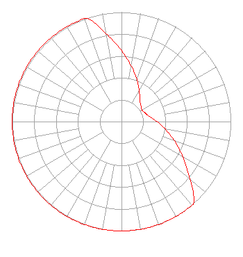 | ||||||||||||||||||
| Azimuth | Ratio | Azimuth | Ratio | Azimuth | Ratio | Azimuth | Ratio | ||||||||||||
| 0 | 0.648 | 10 | 0.515 | 20 | 0.409 | 30 | 0.325 | ||||||||||||
| 40 | 0.259 | 50 | 0.232 | 60 | 0.215 | 70 | 0.231 | ||||||||||||
| 80 | 0.261 | 90 | 0.325 | 100 | 0.409 | 110 | 0.514 | ||||||||||||
| 120 | 0.648 | 130 | 0.815 | 139 | 1.000 | 140 | 1.000 | ||||||||||||
| 150 | 1.000 | 160 | 1.000 | 170 | 1.000 | 180 | 1.000 | ||||||||||||
| 190 | 1.000 | 200 | 1.000 | 210 | 1.000 | 220 | 1.000 | ||||||||||||
| 230 | 1.000 | 240 | 1.000 | 250 | 1.000 | 260 | 1.000 | ||||||||||||
| 270 | 1.000 | 280 | 1.000 | 290 | 1.000 | 300 | 1.000 | ||||||||||||
| 310 | 1.000 | 320 | 1.000 | 330 | 1.000 | 340 | 1.000 | ||||||||||||
| 341 | 1.000 | 350 | 0.816 | ||||||||||||||||
Structure Registration Number 1059095 Structure Type: TOWER Registered To: Gray Media Group, Inc. Structure Address: 6425 Thunder Lake Rd Rhinelander, WI County Name: Oneida County ASR Issued: 08/03/2021 Date Built: 12/21/2000 Site Elevation: 512.1 m (1680 ft.) Structure Height: 151 m (495 ft.) Height Overall: 152.1 m (499 ft.) Overall Height AMSL: 664.2 m (2179 ft.) FAA Determination: 05/25/2000 FAA Study #: 00-AGL-1161-OE FAA Circular #: 70/7460-1K Paint & Light FAA Chapters: 3, 4, 5, 12 PRIOR FAA 98-AGL-3556-OE 45-46-29.8 N 89-14-55.5 W (NAD 83) 45-46-30.0 N 89-14-55.0 W (Converted to NAD 27) |
3319 W. Beltline Hwy Madison, WI 53713 Phone: 608-264-9600 Government Entity | Date: 03/01/2013 Application Certifier STATE OF WISCONSIN - EDUCATIONAL COMMUNICATIONS BOARD 3319 W. Beltline Hwy. Madison, WI 53713 Applicant MARGARET L. MILLER Dow Lohnes Pllc STEPHEN M. BAUDER 3319 W. Beltline Hwy Madison, WI 53713 STAFF ENGINEER | |||||||||||||||||