
FCCInfo.com
A Service of Cavell, Mertz & Associates, Inc.
(855) FCC-INFO
|
|
|
|
|
||||||||||||||||
|
|
W262DN Channel: 262D 100.3 MHz Ionia, Michigan Service: FX - A translator or application for a translator. Facility ID: 202467 Fac. Service: FX Programming Delivery Method: Unspecified Status: License Application Accepted: 03/14/2019 Application Granted: 03/20/2019 File Number: BLFT-20190314AAB License Expires: 00/00/0000 Prefix Type: This is a license for a translator Application Type: License To Cover FCC Website Links: LMS Facility Details This Application CDBS Application Other W262DN Applications Other W262DN Applications in CDBS Including Superseded Applications Mailing Address Correspondence for W262DN Correspondence related to application BLFT-20190314AAB Service Contour - Open Street Map or USGS Map (60 dBu) Service Contour - KML / Google Earth (60 dBu) Class: D, A Noncommercial educational operating with no more than 10W Site Location: 42-56-30.1 N 85-20-03.1 W (NAD 83) Site Location: 42-56-30.0 N 85-20-03.0 W (Converted to NAD 27) Effective Radiated Power: 0.25 kW Transmitter Output Power: 0.664 kW Antenna Center HAAT: 0 m Antenna Center AMSL: 258 m (846 ft.) Antenna Center HAG: 20 m (66 ft.) Site Elevation: 238 m. (781 ft.) Height Overall*: 28 m (92 ft.) (* As Filed In This Application, may differ from ASR Data, Below.) Directional Antenna Antenna Make/Model: None Antenna ID: 132508 Polarization:
| ||||||||||||||||||
| Antenna Data for Antenna Id: 132508 W262DN FX File: BLFT-20190314AAB None - Service: FX Pattern and Field Values Include a 180° Clockwise Rotation | 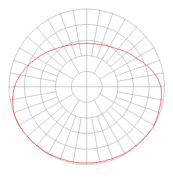 | ||||||||||||||||||
| Azimuth | Ratio | Azimuth | Ratio | Azimuth | Ratio | Azimuth | Ratio | ||||||||||||
| 0 | 0.553 | 10 | 0.558 | 20 | 0.571 | 30 | 0.594 | ||||||||||||
| 40 | 0.628 | 50 | 0.682 | 60 | 0.738 | 70 | 0.815 | ||||||||||||
| 80 | 0.897 | 90 | 0.953 | 100 | 0.973 | 110 | 0.983 | ||||||||||||
| 120 | 1.000 | 130 | 0.992 | 140 | 0.988 | 150 | 0.988 | ||||||||||||
| 160 | 0.983 | 170 | 0.983 | 180 | 0.983 | 190 | 0.983 | ||||||||||||
| 200 | 0.983 | 210 | 0.988 | 220 | 0.988 | 230 | 0.992 | ||||||||||||
| 240 | 1.000 | 250 | 0.991 | 260 | 0.963 | 270 | 0.923 | ||||||||||||
| 280 | 0.862 | 290 | 0.797 | 300 | 0.731 | 310 | 0.676 | ||||||||||||
| 320 | 0.628 | 330 | 0.594 | 340 | 0.571 | 350 | 0.558 | ||||||||||||
Structure Registration Number 1061332 Structure Type: TOWER Registered To: Lowell, City of Structure Address: 830 Shepard Blvd. Lowell, MI County Name: Kent County ASR Issued: 10/09/2007 Date Built: 10/17/1994 Site Elevation: 237.7 m (780 ft.) Structure Height: 27.7 m (91 ft.) Height Overall: 27.7 m (91 ft.) Overall Height AMSL: 265.4 m (871 ft.) FAA Determination: 03/18/1999 FAA Study #: 99-AGL-0174-OE FAA Circular #: 70/7460-1H Paint & Light FAA Chapters: 3, 4, 5, 13 REFER TO PRIOR STUDY 93-AGL-2574-OE 42-56-30.0 N 85-20-03.0 W (NAD 83) 42-56-29.9 N 85-20-02.9 W (Converted to NAD 27) |
1150 Haynor Road Ionia, MI 48846-8532 Phone: 616-527-9466 | Date: 03/14/2019 Application Certifier PACKER RADIO WION, LLC 1150 Haynor Road Ionia, MI 48846-8532 Applicant MATTHEW H. MCCORMICK, ESQ Fletcher, Heald & Hildreth, P.l.c. 1300 North 17th Street 11th Floor Arlington, VA 22209 BRUCE BELLAMY Munn-reese Po Box 220 Coldwater, MI 49036 CONSULTING ENGINEER | |||||||||||||||||