
FCCInfo.com
A Service of Cavell, Mertz & Associates, Inc.
(855) FCC-INFO
|
|
WSHN from 02/17/2011 |
|
|
||||||||||||||||
|
|
WSHN Channel: 207C0 89.3 MHz Munising, Michigan Service: FM - A full-service FM station or application. Facility ID: 173326 Fac. Service: FM Status: License Application Accepted: 01/17/2014 Application Granted: 01/28/2014 File Number: BLED-20140117AOF License Expires: 00/00/0000 Prefix Type: This is a license for a noncommercial educational FM station Application Type: Amendment FCC Website Links: LMS Facility Details This Application CDBS Application Other WSHN Applications Other WSHN Applications in CDBS Including Superseded Applications Mailing Address Correspondence for WSHN Correspondence related to application BLED-20140117AOF Service Contour - Open Street Map or USGS Map (60 dBu) Service Contour - KML / Google Earth (60 dBu) Public Inspection Files Facility Type: NON-COMMERCIAL EDUC. FM Class: C0, C0 Site Location: 46-36-13.8 N 87-37-15.5 W (NAD 83) Site Location: 46-36-14.0 N 87-37-15.0 W (Converted to NAD 27) Effective Radiated Power: 100 kW Horiz. ; 0 kW Vert. Transmitter Output Power: 5.7 kW Antenna Center HAAT: 313 m Horiz.; 0 m Vert. Antenna Center AMSL: 694 m Horiz.; 0 m Vert. Antenna Center HAG: 212 m Horiz.; 0 m Vert. Calculated Site Elevation: 482 m. (1581 ft.) Height Overall*: 213 m (699 ft.) (* As Filed In This Application, may differ from ASR Data, Below.) Directional Antenna Antenna Make/Model: ETC FM-3HP-DA, three sections Antenna ID: 117274 Polarization: | ||||||||||||||||||
| Antenna Data for Antenna Id: 117274 WSHN FM File: BLED-20140117AOF ETC - FM-3HP-DA, three sections Service: FM Pattern and Field Values Include a 115° Clockwise Rotation | 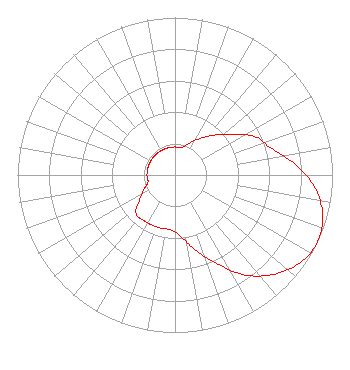 | ||||||||||||||||||
| Azimuth | Ratio | Azimuth | Ratio | Azimuth | Ratio | Azimuth | Ratio | ||||||||||||
| 5 | 0.178 | 15 | 0.180 | 25 | 0.226 | 35 | 0.285 | ||||||||||||
| 45 | 0.359 | 55 | 0.452 | 65 | 0.569 | 75 | 0.638 | ||||||||||||
| 85 | 0.767 | 95 | 0.891 | 105 | 0.970 | 115 | 1.000 | ||||||||||||
| 125 | 0.970 | 135 | 0.891 | 145 | 0.776 | 155 | 0.617 | ||||||||||||
| 165 | 0.490 | 175 | 0.389 | 185 | 0.350 | 195 | 0.350 | ||||||||||||
| 205 | 0.350 | 215 | 0.350 | 225 | 0.350 | 235 | 0.275 | ||||||||||||
| 245 | 0.219 | 255 | 0.178 | 265 | 0.178 | 275 | 0.178 | ||||||||||||
| 285 | 0.178 | 295 | 0.178 | 305 | 0.178 | 315 | 0.178 | ||||||||||||
| 325 | 0.178 | 335 | 0.178 | 345 | 0.178 | 355 | 0.178 | ||||||||||||
Structure Registration Number 1230855 [ASR Heights Differ from WSHN Application] Structure Type: GTOWER Registered To: 510 Tower L.L.C. Structure Address: 0.5 Miles North Of County Road 510 Marquette, MI County Name: Marquette County ASR Issued: 04/29/2022 Date Built: 11/09/2001 Site Elevation: 481.5 m (1580 ft.) Structure Height: 212.1 m (696 ft.) Height Overall: 213.1 m (699 ft.) Overall Height AMSL: 694.6 m (2279 ft.) FAA Determination: 10/09/2001 FAA Study #: 2001-AGL-4969-OE Paint & Light FAA Chapters: 1, 3, 4, 13, 21 RED LIGHTS AND PAINT 46-36-14.1 N 87-37-15.1 W (NAD 83) 46-36-14.3 N 87-37-14.6 W (Converted to NAD 27) |
Marquette, MI 49855 Phone: 906-475-9999 Not-for-Profit | Date: 01/17/2014 Application Certifier CHRISTIANRADIOBROADCASTING.ORG, INC. 109 Zorza Drive Ishpeming, MI 49849 Applicant EDWARD CZELADA 3302 N. Van Dyke Rd. Imlay City, MI 48444 CONSULTING ENGINEER RITA NOORDYK Christianradiobroadcasting.org, Inc. | |||||||||||||||||