
FCCInfo.com
A Service of Cavell, Mertz & Associates, Inc.
(855) FCC-INFO
|
|
WTOD from 06/22/2009 WTOD from 05/30/2000 WTOD from 08/01/1994 WTOD from 12/21/1990 WTOD from 05/07/1990 |
|
|
||||||||||||||||
|
|
WTOD Channel: 293A 106.5 MHz Delta, Ohio Service: FM - A full-service FM station or application. Facility ID: 67275 Fac. Service: FM Analog & Digital Status: License 73.215 Station Application Accepted: 03/25/2003 Application Granted: 04/07/2003 File Number: BLH-20030325ADT License Expires: 00/00/0000 Prefix Type: This is a license for a commercial FM station Application Type: License To Cover FCC Website Links: LMS Facility Details This Application CDBS Application Other WTOD Applications Other WTOD Applications in CDBS Including Superseded Applications Mailing Address Correspondence for WTOD Correspondence related to application BLH-20030325ADT Service Contour - Open Street Map or USGS Map (60 dBu) Service Contour - KML / Google Earth (60 dBu) Public Inspection Files Facility Type: FM STATION Class: A, A Zone I; I-A; or II station; with 0.1kW-6kW ERP and a class contour distance <=28km Site Location: 41-30-49.2 N 83-50-59.8 W (NAD 83) Site Location: 41-30-49.0 N 83-51-00.0 W (Converted to NAD 27) Effective Radiated Power: 4.8 kW Transmitter Output Power: 4.798 kW Antenna Center HAAT: 111.9 m (367 ft.) Antenna Center AMSL: 308.8 m (1013 ft.) Antenna Center HAG: 106.7 m (350 ft.) Calculated Site Elevation: 202.1 m. (663 ft.) Height Overall*: 110.6 m (363 ft.) (* As Filed In This Application, may differ from ASR Data, Below.) Directional Antenna Antenna Make/Model: DIELECTRIC DCRM2E5D Antenna ID: 46334 Polarization:
| ||||||||||||||||||
| Antenna Data for Antenna Id: 46334 WTOD FM File: BLH-20030325ADT DIELECTRIC - DCRM2E5D Service: FM | 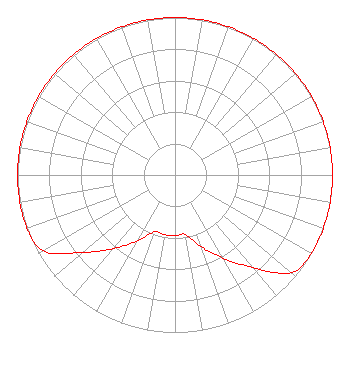 | ||||||||||||||||||
| Azimuth | Ratio | Azimuth | Ratio | Azimuth | Ratio | Azimuth | Ratio | ||||||||||||
| 0 | 1.000 | 10 | 1.000 | 20 | 1.000 | 30 | 1.000 | ||||||||||||
| 40 | 1.000 | 50 | 1.000 | 60 | 1.000 | 70 | 1.000 | ||||||||||||
| 80 | 1.000 | 90 | 1.000 | 100 | 1.000 | 110 | 1.000 | ||||||||||||
| 120 | 1.000 | 130 | 0.964 | 140 | 0.766 | 150 | 0.609 | ||||||||||||
| 160 | 0.485 | 170 | 0.385 | 180 | 0.385 | 190 | 0.385 | ||||||||||||
| 200 | 0.385 | 210 | 0.485 | 220 | 0.609 | 230 | 0.766 | ||||||||||||
| 240 | 0.964 | 250 | 1.000 | 260 | 1.000 | 270 | 1.000 | ||||||||||||
| 280 | 1.000 | 290 | 1.000 | 300 | 1.000 | 310 | 1.000 | ||||||||||||
| 320 | 1.000 | 330 | 1.000 | 340 | 1.000 | 350 | 1.000 | ||||||||||||
Structure Registration Number 1237558 Structure Type: TOWER Registered To: VB Nimbus, LLC Structure Address: 12930 Archbold Whitehouse Road Whitehouse, OH County Name: Lucas County ASR Issued: 10/13/2020 Date Built: 03/25/2003 Site Elevation: 202.1 m (663 ft.) Structure Height: 109.7 m (360 ft.) Height Overall: 110.6 m (363 ft.) Overall Height AMSL: 312.7 m (1026 ft.) FAA Determination: 01/23/2003 FAA Study #: 2002-AGL-6651-OE FAA Circular #: 70/7460-1K Paint & Light FAA Chapters: 4, 8, 12 41-30-49.4 N 83-51-00.0 W (NAD 83) 41-30-49.2 N 83-51-00.2 W (Converted to NAD 27) |
3780 Will Scarlet Road Winston-salem, NC 27104 Phone: 336-765-7438 Private Not-for-Profit Educational Institution | Date: 03/25/2003 Application Certifier CUMULUS LICENSING CORP. Cumulus Licensing Corp. 3535 Piedmont Road Building 14, 14th Floor Atlanta, GA 30305 Applicant VIRGLE LEON STRICKLAND 12585 Old Highway 280 East Suite 102 Chelsea, AL 35043 TECHNICAL CONSULTANT MARK N. LIPP, ESQ Shook, Hardy & Bacon Llp | |||||||||||||||||
| |||||||||||||||||||