
FCCInfo.com
A Service of Cavell, Mertz & Associates, Inc.
(855) FCC-INFO
|
|
|
|
|
||||||||||||||||
|
|
K245AF Channel: 245D 96.9 MHz The Dalles, Oregon Service: FX - A translator or application for a translator. Facility ID: 149243 Fac. Service: FX Programming Delivery Method: Unspecified Status: License Application Accepted: 11/04/2008 Application Granted: 12/04/2008 File Number: BLFT-20081104ABM License Expires: 00/00/0000 Prefix Type: This is a license for a translator Application Type: License To Cover FCC Website Links: LMS Facility Details This Application CDBS Application Other K245AF Applications Other K245AF Applications in CDBS Including Superseded Applications Mailing Address Correspondence for K245AF Correspondence related to application BLFT-20081104ABM Service Contour - Open Street Map or USGS Map (60 dBu) Service Contour - KML / Google Earth (60 dBu) Class: D, A Noncommercial educational operating with no more than 10W Site Location: 45-37-23.4 N 121-05-37.3 W (NAD 83) Site Location: 45-37-24.0 N 121-05-33.0 W (Converted to NAD 27) Effective Radiated Power: 0.099 kW Horiz. ; 0 kW Vert. Transmitter Output Power: 0.021 kW Antenna Center HAAT: -14.3 m Horiz.; 0 m Vert. Antenna Center AMSL: 303 m Horiz.; 0 m Vert. Antenna Center HAG: 10 m Horiz.; 0 m Vert. Site Elevation: 293 m. (961 ft.) Height Overall*: 15 m (49 ft.) (* As Filed In This Application, may differ from ASR Data, Below.) Directional Antenna Antenna Make/Model: None Antenna ID: 16153 Polarization:
| ||||||||||||||||||
| Antenna Data for Antenna Id: 16153 K245AF FX File: BLFT-20081104ABM None - Service: FX Pattern and Field Values Include a 245° Clockwise Rotation | 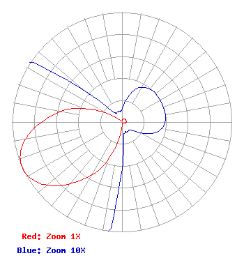 | ||||||||||||||||||
| Azimuth | Ratio | Azimuth | Ratio | Azimuth | Ratio | Azimuth | Ratio | ||||||||||||
| 5 | 0.015 | 15 | 0.025 | 25 | 0.034 | 35 | 0.038 | ||||||||||||
| 45 | 0.040 | 55 | 0.040 | 65 | 0.040 | 75 | 0.040 | ||||||||||||
| 85 | 0.040 | 95 | 0.038 | 105 | 0.034 | 115 | 0.025 | ||||||||||||
| 125 | 0.015 | 135 | 0.010 | 145 | 0.010 | 155 | 0.010 | ||||||||||||
| 165 | 0.010 | 175 | 0.020 | 185 | 0.085 | 195 | 0.250 | ||||||||||||
| 205 | 0.470 | 215 | 0.645 | 225 | 0.820 | 235 | 0.950 | ||||||||||||
| 245 | 1.000 | 255 | 0.950 | 265 | 0.820 | 275 | 0.645 | ||||||||||||
| 285 | 0.470 | 295 | 0.250 | 305 | 0.085 | 315 | 0.020 | ||||||||||||
| 325 | 0.010 | 335 | 0.010 | 345 | 0.010 | 355 | 0.010 | ||||||||||||
Structure Registration Number 1264721 Structure Type: POLE Registered To: WASCO COUNTY SHERIFF'S OFFICE Structure Address: Signal Hill The Dalles, OR County Name: Wasco County ASR Issued: 08/15/2008 Date Built: 01/01/2000 Site Elevation: 292.6 m (960 ft.) Structure Height: 15.2 m (50 ft.) Height Overall: 15.2 m (50 ft.) Overall Height AMSL: 307.8 m (1010 ft.) FAA Determination: 08/12/2008 FAA Study #: 2008-ANM-2355-OE Paint & Light FAA Chapters: NONE PRIOR STUDY 1999-ANM-1960-OE 45-37-23.1 N 121-05-37.0 W (NAD 83) 45-37-23.7 N 121-05-32.7 W (Converted to NAD 27) |
1 Blackfield Drive # 333 Tiburon, CA 94920 Phone: 415-789-5035 | Date: 11/04/2008 Application Certifier BICOASTAL MEDIA LICENSES IV, LLC 1 Blackfield Drive #333 Tiburon, CA 94920 Applicant ERIK C. SWANSON, P.E. Hatfield & Dawson Consulting Engineers 9500 Greenwood Ave N Seattle, WA 98103 CONSULTING ENGINEER ERWIN G. KRASNOW, ESQ. Garvey Schubert Barer 1000 Potomac Street, N.w. 5th Floor Washington, DC 20007-3501 | |||||||||||||||||