
FCCInfo.com
A Service of Cavell, Mertz & Associates, Inc.
(855) FCC-INFO
|
|
W287BL from 06/02/2004 |
|
|
||||||||||||||||
|
|
W287BL Channel: 287D 105.3 MHz Elkhart, Indiana Service: FX - A translator or application for a translator. Facility ID: 150311 Fac. Service: FX Programming Delivery Method: Unspecified Status: License Application Accepted: 04/14/2008 Application Granted: 05/19/2008 File Number: BLFT-20080414ANX License Expires: 00/00/0000 Prefix Type: This is a license for a translator Application Type: License To Cover FCC Website Links: LMS Facility Details This Application CDBS Application Other W287BL Applications Other W287BL Applications in CDBS Including Superseded Applications Mailing Address Correspondence for W287BL Correspondence related to application BLFT-20080414ANX Service Contour - Open Street Map or USGS Map (60 dBu) Service Contour - KML / Google Earth (60 dBu) Class: D, A Noncommercial educational operating with no more than 10W Site Location: 41-37-18.2 N 85-57-38.0 W (NAD 83) Site Location: 41-37-18.0 N 85-57-38.0 W (Converted to NAD 27) Effective Radiated Power: 0.165 kW Transmitter Output Power: 0.203 kW Antenna Center HAAT: 128.2 m Horiz.; 0 m Vert. Antenna Center AMSL: 370 m (1214 ft.) Antenna Center HAG: 123 m (404 ft.) Site Elevation: 247 m. (810 ft.) Height Overall*: 149 m (489 ft.) (* As Filed In This Application, may differ from ASR Data, Below.) Directional Antenna Antenna Make/Model: None Antenna ID: 84237 Polarization:
| ||||||||||||||||||
| Antenna Data for Antenna Id: 84237 W287BL FX File: BLFT-20080414ANX None - Service: FX | 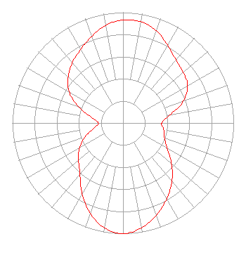 | ||||||||||||||||||
| Azimuth | Ratio | Azimuth | Ratio | Azimuth | Ratio | Azimuth | Ratio | ||||||||||||
| 0 | 0.930 | 10 | 0.929 | 20 | 0.886 | 30 | 0.808 | ||||||||||||
| 40 | 0.743 | 50 | 0.710 | 60 | 0.674 | 70 | 0.580 | ||||||||||||
| 80 | 0.435 | 90 | 0.350 | 100 | 0.375 | 110 | 0.400 | ||||||||||||
| 120 | 0.460 | 130 | 0.571 | 140 | 0.688 | 150 | 0.789 | ||||||||||||
| 160 | 0.886 | 170 | 0.962 | 180 | 1.000 | 190 | 0.963 | ||||||||||||
| 200 | 0.868 | 210 | 0.738 | 220 | 0.606 | 230 | 0.524 | ||||||||||||
| 240 | 0.453 | 250 | 0.360 | 260 | 0.265 | 270 | 0.222 | ||||||||||||
| 280 | 0.286 | 290 | 0.425 | 300 | 0.563 | 310 | 0.646 | ||||||||||||
| 320 | 0.712 | 330 | 0.766 | 340 | 0.830 | 350 | 0.896 | ||||||||||||
Structure Registration Number 1217762 Structure Type: TOWER Registered To: Progressive Broadcasting System, Inc. Structure Address: 25802 Cr 26 Elkhart, IN County Name: Elkhart County ASR Issued: 08/05/2010 Date Built: 04/01/1980 Site Elevation: 246.9 m (810 ft.) Structure Height: 148 m (486 ft.) Height Overall: 149 m (489 ft.) Overall Height AMSL: 395.9 m (1299 ft.) FAA Determination: 09/01/2000 FAA Study #: 00-AGL-5280-OE Paint & Light FAA Chapters: 1, 3, 4, 13, 21 PRIOR FAA 78-AGL-1775-OE CONTINUE OM&L PAINT RED LIGHTS 41-37-18.1 N 85-57-37.6 W (NAD 83) 41-37-17.9 N 85-57-37.6 W (Converted to NAD 27) |
P.o. Box 307 Elkhart, IN 46515 Phone: 219-875-5166 | Date: 04/14/2008 Application Certifier PROGRESSIVE BROADCASTING SYSTEM, INC. P.o. Box 307 Elkhart, IN 46515 Applicant JAMES BELLAIRE Box 307 Elkhart, IN 46515-0307 TECHNICAL OPERATIONS MATTHEW H. MCCORMICK, ESQ. Fletcher, Heald & Hildreth, P.l.c. 1300 North 17th Street 11th Floor Arlington, VA 22209 | |||||||||||||||||