
FCCInfo.com
A Service of Cavell, Mertz & Associates, Inc.
(855) FCC-INFO
|
|
|
|  |
|
|||||||||||||||
|
|
WCDY Channel: 300A 107.9 MHz Mcbain, Michigan Service: FM - A full-service FM station or application. Facility ID: 183306 Fac. Service: FM Status: License 73.215 Station Application Accepted: 10/18/2010 Application Granted: 10/27/2010 File Number: BLH-20101018AAX License Expires: 00/00/0000 Prefix Type: This is a license for a commercial FM station Application Type: License To Cover FCC Website Links: LMS Facility Details This Application CDBS Application Other WCDY Applications Other WCDY Applications in CDBS Including Superseded Applications Mailing Address Correspondence for WCDY Correspondence related to application BLH-20101018AAX Service Contour - Open Street Map or USGS Map (60 dBu) Service Contour - KML / Google Earth (60 dBu) Public Inspection Files Facility Type: FM STATION Class: A, A Zone I; I-A; or II station; with 0.1kW-6kW ERP and a class contour distance <=28km Site Location: 44-10-16.0 N 85-20-14.0 W (NAD 83) Site Location: 44-10-16.0 N 85-20-13.8 W (Converted to NAD 27) Effective Radiated Power: 3.1 kW Transmitter Output Power: 2.13 kW Antenna Center HAAT: 140 m (459 ft.) Antenna Center AMSL: 544.9 m (1788 ft.) Antenna Center HAG: 109 m (358 ft.) Calculated Site Elevation: 435.9 m. (1430 ft.) Height Overall*: 123.2 m (404 ft.) (* As Filed In This Application, may differ from ASR Data, Below.) Directional Antenna Antenna Make/Model: Shivley 6810-2R-DA, two sections Antenna ID: 99186 Polarization: | ||||||||||||||||||
| Antenna Data for Antenna Id: 99186 WCDY FM File: BLH-20101018AAX Shivley - 6810-2R-DA, two sections Service: FM | 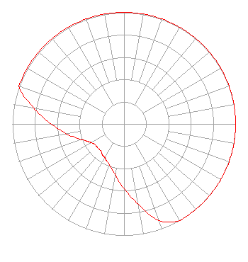 | ||||||||||||||||||
| Azimuth | Ratio | Azimuth | Ratio | Azimuth | Ratio | Azimuth | Ratio | ||||||||||||
| 0 | 1.000 | 10 | 1.000 | 20 | 1.000 | 30 | 1.000 | ||||||||||||
| 40 | 1.000 | 50 | 1.000 | 60 | 1.000 | 70 | 1.000 | ||||||||||||
| 80 | 1.000 | 90 | 1.000 | 100 | 1.000 | 110 | 1.000 | ||||||||||||
| 120 | 1.000 | 130 | 1.000 | 140 | 1.000 | 150 | 1.000 | ||||||||||||
| 160 | 0.921 | 170 | 0.732 | 180 | 0.581 | 190 | 0.462 | ||||||||||||
| 200 | 0.389 | 205 | 0.367 | 210 | 0.346 | 215 | 0.338 | ||||||||||||
| 220 | 0.319 | 230 | 0.319 | 235 | 0.319 | 240 | 0.338 | ||||||||||||
| 245 | 0.367 | 250 | 0.411 | 260 | 0.518 | 270 | 0.652 | ||||||||||||
| 280 | 0.821 | 290 | 1.000 | 300 | 1.000 | 310 | 1.000 | ||||||||||||
| 320 | 1.000 | 330 | 1.000 | 340 | 1.000 | 350 | 1.000 | ||||||||||||
Structure Registration Number 1000702 Structure Type: TOWER Registered To: Up North Radio, LLC Structure Address: End Of Road 49 Cadillac, MI County Name: Wexford County ASR Issued: 09/30/2016 Date Built: 01/01/1991 Site Elevation: 435.9 m (1430 ft.) Structure Height: 122 m (400 ft.) Height Overall: 123.2 m (404 ft.) Overall Height AMSL: 559 m (1834 ft.) FAA Determination: 06/19/1991 FAA Study #: 91-AGL-524-OE Paint & Light FAA Chapters: 1, 3, 12, 21 RED LIGHTS/PAINT 44-10-16.0 N 85-20-14.0 W (NAD 83) 44-10-16.0 N 85-20-13.8 W (Converted to NAD 27) |
8082 E M-115 Suite B Cadillac, MI 49601 Phone: 231-876-1079 | Date: 10/18/2010 Application Certifier UP NORTH RADIO, LLC 7839 E Oakland Manor Dr Waterford, MI 48327 Applicant ALFRED S KENYON III 3440 Little Hunting Creek Dr Alexandria, VA 22309-1928 TECHNICAL CONSULTANT JENNIFER THEODORE Up North Radio, Llc | |||||||||||||||||
| |||||||||||||||||||