
FCCInfo.com
A Service of Cavell, Mertz & Associates, Inc.
(855) FCC-INFO
|
|
|
|
|
||||||||||||||||
|
|
W284BI Channel: 284D 104.7 MHz Vandalia, Illinois Service: FX - A translator or application for a translator. Facility ID: 139303 Fac. Service: FX Programming Delivery Method: Unspecified Status: License Application Accepted: 12/06/2011 Application Granted: 04/19/2013 File Number: BLFT-20111206ACG License Expires: 00/00/0000 Prefix Type: This is a license for a translator Application Type: License To Cover FCC Website Links: LMS Facility Details This Application CDBS Application Other W284BI Applications Other W284BI Applications in CDBS Including Superseded Applications Mailing Address Correspondence for W284BI Correspondence related to application BLFT-20111206ACG Service Contour - Open Street Map or USGS Map (60 dBu) Service Contour - KML / Google Earth (60 dBu) Class: D, A Noncommercial educational operating with no more than 10W Site Location: 38-56-35.2 N 89-06-13.2 W (NAD 83) Site Location: 38-56-35.0 N 89-06-13.0 W (Converted to NAD 27) Effective Radiated Power: 0 kW Horiz. ; 0.25 kW Vert. Transmitter Output Power: 0.118 kW Antenna Center HAAT: 135.3 m Horiz.; 0 m Vert. Antenna Center AMSL: 0 m Horiz.; 289 m Vert. Antenna Center HAG: 0 m Horiz.; 105 m Vert. Site Elevation: 184 m. (604 ft.) Height Overall*: 127 m (417 ft.) (* As Filed In This Application, may differ from ASR Data, Below.) Directional Antenna Antenna Make/Model: None Antenna ID: 106614 Polarization:
| ||||||||||||||||||
| Antenna Data for Antenna Id: 106614 W284BI FX File: BLFT-20111206ACG None - Service: FX | 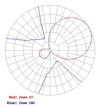 | ||||||||||||||||||
| Azimuth | Ratio | Azimuth | Ratio | Azimuth | Ratio | Azimuth | Ratio | ||||||||||||
| 0 | 0.388 | 10 | 0.570 | 20 | 0.715 | 30 | 0.829 | ||||||||||||
| 40 | 0.920 | 50 | 0.979 | 60 | 1.000 | 70 | 0.979 | ||||||||||||
| 80 | 0.920 | 90 | 0.829 | 100 | 0.715 | 110 | 0.570 | ||||||||||||
| 120 | 0.388 | 130 | 0.187 | 140 | 0.045 | 150 | 0.030 | ||||||||||||
| 160 | 0.032 | 170 | 0.037 | 180 | 0.046 | 190 | 0.065 | ||||||||||||
| 200 | 0.142 | 210 | 0.202 | 220 | 0.234 | 230 | 0.250 | ||||||||||||
| 240 | 0.260 | 250 | 0.250 | 260 | 0.234 | 270 | 0.202 | ||||||||||||
| 280 | 0.142 | 290 | 0.065 | 300 | 0.046 | 310 | 0.037 | ||||||||||||
| 320 | 0.032 | 330 | 0.030 | 340 | 0.045 | 350 | 0.187 | ||||||||||||
Structure Registration Number 1209173 [ASR Heights Differ from W284BI Application] Structure Type: GTOWER Registered To: American Towers LLC Structure Address: 1118 Carlye Rd. Vandalia, IL County Name: Fayette County ASR Issued: 11/11/2020 Date Built: 03/29/2000 Site Elevation: 184.4 m (605 ft.) Structure Height: 121.9 m (400 ft.) Height Overall: 126.5 m (415 ft.) Overall Height AMSL: 310.9 m (1020 ft.) FAA Determination: 10/29/2020 FAA Study #: 2020-AGL-18792-OE FAA Circular #: 70/7460-1G Paint & Light FAA Chapters: 3, 4, 5, 9 PRIOR STUDIES 1999-AGL-6244-OE / 2013-AGL-4039-OE 38-56-33.8 N 89-06-11.8 W (NAD 83) 38-56-33.6 N 89-06-11.6 W (Converted to NAD 27) |
P.o. Box 150846 Nashville, TN 37215 Phone: 615-361-7560 | Date: 12/06/2011 Application Certifier TWO PETAZ, INC. P.o. Box 150846 Nashville, TN 37215 Applicant CHARLES M. ANDERSON Anderson Associates 1519 Euclid Avenue Bowling Green, KY 42103 CONSULTANT JOHN F. GARZIGLIA, ESQ. Womble Carlyle Sandridge & Rice, Llp 1200 19th Street, N.w., Suite 500 Washington, DC 20036 | |||||||||||||||||