
FCCInfo.com
A Service of Cavell, Mertz & Associates, Inc.
(855) FCC-INFO
|
|
|
|
|
||||||||||||||||
|
|
W273BC Channel: 273D 102.5 MHz Williamson, West Virginia Service: FX - A translator or application for a translator. Facility ID: 141986 Fac. Service: FX Programming Delivery Method: Unspecified Status: License Application Accepted: 12/05/2011 Application Granted: 09/20/2012 File Number: BLFT-20111205AKR License Expires: 00/00/0000 Prefix Type: This is a license for a translator Application Type: License To Cover FCC Website Links: LMS Facility Details This Application CDBS Application Other W273BC Applications Other W273BC Applications in CDBS Including Superseded Applications Mailing Address Correspondence for W273BC Correspondence related to application BLFT-20111205AKR Service Contour - Open Street Map or USGS Map (60 dBu) Service Contour - KML / Google Earth (60 dBu) Class: D, A Noncommercial educational operating with no more than 10W Site Location: 37-40-09.4 N 82-16-08.5 W (NAD 83) Site Location: 37-40-09.0 N 82-16-09.0 W (Converted to NAD 27) Effective Radiated Power: 0.19 kW Transmitter Output Power: 0.361 kW Antenna Center HAAT: 125.7 m Horiz.; 0 m Vert. Antenna Center AMSL: 464 m (1522 ft.) Antenna Center HAG: 98 m (322 ft.) Site Elevation: 366 m. (1201 ft.) Height Overall*: 130 m (427 ft.) (* As Filed In This Application, may differ from ASR Data, Below.) Directional Antenna Antenna Make/Model: None Antenna ID: 105758 Polarization:
| ||||||||||||||||||
| Antenna Data for Antenna Id: 105758 W273BC FX File: BLFT-20111205AKR None - Service: FX | 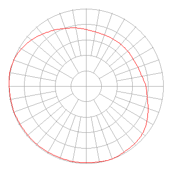 | ||||||||||||||||||
| Azimuth | Ratio | Azimuth | Ratio | Azimuth | Ratio | Azimuth | Ratio | ||||||||||||
| 0 | 0.732 | 10 | 0.710 | 20 | 0.702 | 30 | 0.702 | ||||||||||||
| 40 | 0.702 | 50 | 0.702 | 60 | 0.702 | 70 | 0.712 | ||||||||||||
| 80 | 0.732 | 90 | 0.772 | 100 | 0.802 | 110 | 0.853 | ||||||||||||
| 120 | 0.909 | 130 | 0.953 | 140 | 0.973 | 150 | 0.983 | ||||||||||||
| 160 | 1.000 | 170 | 0.992 | 180 | 0.988 | 190 | 0.988 | ||||||||||||
| 200 | 0.983 | 210 | 0.983 | 220 | 0.983 | 230 | 0.983 | ||||||||||||
| 240 | 0.983 | 250 | 0.988 | 260 | 0.988 | 270 | 0.992 | ||||||||||||
| 280 | 1.000 | 290 | 0.991 | 300 | 0.963 | 310 | 0.923 | ||||||||||||
| 320 | 0.873 | 330 | 0.832 | 340 | 0.792 | 350 | 0.762 | ||||||||||||
Structure Registration Number 1035258 Structure Type: TOWER Registered To: Mountain Top Media LLC Structure Address: Tower Rd E Town Williamson, WV County Name: Mingo County ASR Issued: 06/28/2019 Date Built: 09/01/1978 Site Elevation: 365.7 m (1200 ft.) Structure Height: 128.1 m (420 ft.) Height Overall: 130.1 m (427 ft.) Overall Height AMSL: 495.8 m (1627 ft.) FAA Determination: 01/23/1998 FAA Study #: 97-AEA-3767-OE FAA Circular #: 70/7460-1J Paint & Light FAA Chapters: 3, 4, 5, 13 37-40-09.0 N 82-16-09.0 W (NAD 83) 37-40-08.6 N 82-16-09.5 W (Converted to NAD 27) |
P.o. Box 2040 Pikeville, KY 41502 Phone: 606-437-4051 Limited Liability Company | Date: 12/05/2011 Application Certifier EAST KENTUCKY BROADCASTING CORPORATION 1240 Radio Drive Pikeville, KY 41502 Applicant PAUL MANUEL East Kentucky Broadcasting Corp. 275 Adams Cemetary Road Prestonsburg, KY 41653 ENGINEER JOHN F. GARZIGLIA, ESQ. Womble Carlyle Sandridge & Rice, Pllc 1200 19th Street, N.w. Suite 500 Washington, DC 20036 | |||||||||||||||||