
FCCInfo.com
A Service of Cavell, Mertz & Associates, Inc.
(855) FCC-INFO
|
|
WMVY from 06/09/2014 WMVY from 05/28/2014 WMVY from 06/16/2008 |
|
|
||||||||||||||||
|
|
WMVY Channel: 204B1 88.7 MHz Edgartown, Massachusetts Service: FM - A full-service FM station or application. Facility ID: 175715 Fac. Service: FM Status: License Application Accepted: 07/14/2015 Application Granted: 08/14/2015 File Number: BLED-20150714ACU License Expires: 00/00/0000 Prefix Type: This is a license for a noncommercial educational FM station Application Type: Amendment FCC Website Links: LMS Facility Details This Application CDBS Application Other WMVY Applications Other WMVY Applications in CDBS Including Superseded Applications Mailing Address Correspondence for WMVY Correspondence related to application BLED-20150714ACU Service Contour - Open Street Map or USGS Map (60 dBu) Service Contour - KML / Google Earth (60 dBu) Public Inspection Files Facility Type: NON-COMMERCIAL EDUC. FM Class: B1, A Zone I or I-A station; with 6kW-25kW ERP and a class contour distance 28km-39km Site Location: 41-26-16.4 N 70-36-48.1 W (NAD 83) Site Location: 41-26-16.0 N 70-36-50.0 W (Converted to NAD 27) Effective Radiated Power: 13 kW Transmitter Output Power: 6.45 kW Antenna Center HAAT: 83 m (272 ft.) Antenna Center AMSL: 88 m (289 ft.) Antenna Center HAG: 48 m (157 ft.) Calculated Site Elevation: 40 m. (131 ft.) Height Overall*: 62.4 m (205 ft.) (* As Filed In This Application, may differ from ASR Data, Below.) Directional Antenna Antenna Make/Model: DIELECTRIC DCRH, four sections, 0.5 wavelength spacing Antenna ID: 121919 Polarization:
| ||||||||||||||||||
| Antenna Data for Antenna Id: 121919 WMVY FM File: BLED-20150714ACU DIELECTRIC - DCRH, four sections, 0.5 wavelength spacing Service: FM Pattern and Field Values Include a 357° Clockwise Rotation | 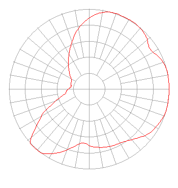 | ||||||||||||||||||
| Azimuth | Ratio | Azimuth | Ratio | Azimuth | Ratio | Azimuth | Ratio | ||||||||||||
| 7 | 0.950 | 17 | 1.000 | 27 | 1.000 | 37 | 1.000 | ||||||||||||
| 47 | 0.970 | 57 | 0.910 | 67 | 0.970 | 77 | 1.000 | ||||||||||||
| 87 | 1.000 | 97 | 1.000 | 107 | 1.000 | 117 | 0.970 | ||||||||||||
| 127 | 0.930 | 137 | 0.850 | 147 | 0.790 | 157 | 0.770 | ||||||||||||
| 167 | 0.750 | 177 | 0.720 | 187 | 0.680 | 197 | 0.776 | ||||||||||||
| 207 | 0.900 | 217 | 1.000 | 227 | 1.000 | 237 | 0.750 | ||||||||||||
| 242 | 0.650 | 247 | 0.501 | 257 | 0.322 | 267 | 0.272 | ||||||||||||
| 277 | 0.227 | 287 | 0.236 | 297 | 0.245 | 307 | 0.300 | ||||||||||||
| 317 | 0.375 | 327 | 0.467 | 337 | 0.582 | 347 | 0.724 | ||||||||||||
| 357 | 0.850 | ||||||||||||||||||
Structure Registration Number 1004416 Structure Type: GTOWER Registered To: American Towers LLC Structure Address: 121 Carroll S Way (10338) Vineyard Haven, MA County Name: Dukes County ASR Issued: 02/23/2024 Date Built: 04/14/2009 Site Elevation: 39.9 m (131 ft.) Structure Height: 60.3 m (198 ft.) Height Overall: 62.5 m (205 ft.) Overall Height AMSL: 102.4 m (336 ft.) FAA Determination: 05/05/2023 FAA Study #: 2023-ANE-1966-OE FAA Circular #: 70/7460-1K Paint & Light FAA Chapters: 3, 4, 5, 12 PRIOR STUDY 2014-ANE-126-OE 41-26-16.2 N 70-36-48.6 W (NAD 83) 41-26-15.8 N 70-36-50.5 W (Converted to NAD 27) |
489 State Road West Tisbury, MA 02575 Phone: 508-693-5000 Not-for-Profit | Date: 07/14/2015 Application Certifier FRIENDS OF MVYRADIO, INC. P.o.box 1148 Vineyard Haven, MA 02568 Applicant BERT GOLDMAN 1511 Radcliffe Way Auburn, CA 95603 TECHNICAL CONSULTANT CATHERINE T. SCHNEIDER, ESQ. Cameron & Mittleman Llp | |||||||||||||||||