
FCCInfo.com
A Service of Cavell, Mertz & Associates, Inc.
(855) FCC-INFO
|
|
|
|
|
||||||||||||||||
|
|
W238CH Channel: 238D 95.5 MHz Decatur, Illinois Service: FX - A translator or application for a translator. Facility ID: 138378 Fac. Service: FX Programming Delivery Method: Unspecified Status: License Application Accepted: 05/13/2014 Application Granted: 06/17/2014 File Number: BLFT-20140513ABI License Expires: 00/00/0000 Prefix Type: This is a license for a translator Application Type: License To Cover FCC Website Links: LMS Facility Details This Application CDBS Application Other W238CH Applications Other W238CH Applications in CDBS Including Superseded Applications Mailing Address Correspondence for W238CH Correspondence related to application BLFT-20140513ABI Service Contour - Open Street Map or USGS Map (60 dBu) Service Contour - KML / Google Earth (60 dBu) Class: D, A Noncommercial educational operating with no more than 10W Site Location: 39-47-11.1 N 88-59-29.3 W (NAD 83) Site Location: 39-47-11.0 N 88-59-29.0 W (Converted to NAD 27) Effective Radiated Power: 0.25 kW Transmitter Output Power: 0.636 kW Antenna Center HAAT: 74.5 m Horiz.; 0 m Vert. Antenna Center AMSL: 274 m (899 ft.) Antenna Center HAG: 63 m (207 ft.) Site Elevation: 211 m. (692 ft.) Height Overall*: 105 m (344 ft.) (* As Filed In This Application, may differ from ASR Data, Below.) Directional Antenna Antenna Make/Model: None Antenna ID: 115250 Polarization:
| ||||||||||||||||||
| Antenna Data for Antenna Id: 115250 W238CH FX File: BLFT-20140513ABI None - Service: FX | 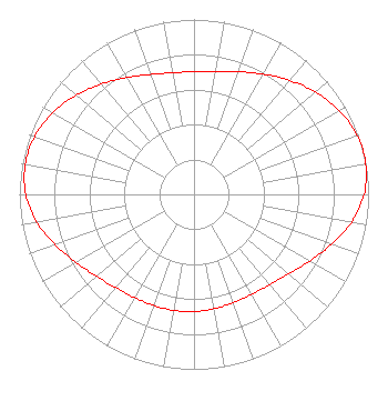 | ||||||||||||||||||
| Azimuth | Ratio | Azimuth | Ratio | Azimuth | Ratio | Azimuth | Ratio | ||||||||||||
| 0 | 0.701 | 10 | 0.715 | 20 | 0.747 | 30 | 0.794 | ||||||||||||
| 40 | 0.851 | 50 | 0.909 | 60 | 0.959 | 70 | 0.993 | ||||||||||||
| 80 | 0.999 | 90 | 0.974 | 100 | 0.916 | 110 | 0.837 | ||||||||||||
| 120 | 0.763 | 130 | 0.708 | 140 | 0.674 | 150 | 0.660 | ||||||||||||
| 160 | 0.659 | 170 | 0.664 | 180 | 0.670 | 190 | 0.673 | ||||||||||||
| 200 | 0.675 | 210 | 0.681 | 220 | 0.696 | 230 | 0.728 | ||||||||||||
| 240 | 0.779 | 250 | 0.845 | 260 | 0.915 | 270 | 0.964 | ||||||||||||
| 280 | 0.982 | 290 | 0.971 | 300 | 0.934 | 310 | 0.882 | ||||||||||||
| 320 | 0.824 | 330 | 0.771 | 340 | 0.729 | 350 | 0.706 | ||||||||||||
Structure Registration Number 1057133 Structure Type: TOWER Registered To: THE CROMWELL GROUP, INC. OF ILLINOIS Structure Address: 0.75 Miles N.w. Elwin, IL County Name: Macon County ASR Issued: 03/14/2017 Date Built: 05/03/2002 Site Elevation: 211 m (692 ft.) Structure Height: 104.2 m (342 ft.) Height Overall: 104.8 m (344 ft.) Overall Height AMSL: 315.8 m (1036 ft.) FAA Determination: 02/23/2001 FAA Study #: 01-AGL-0057-OE Paint & Light FAA Chapters: 1, 3, 11, 21 Removed expiration date from determination. Scenario 1./jjs/case#635066 39-47-10.9 N 88-59-29.4 W (NAD 83) 39-47-10.8 N 88-59-29.1 W (Converted to NAD 27) |
P.o. Box 150846 Nashville, TN 38215-0846 Phone: 615-361-7560 | Date: 05/13/2014 Application Certifier THE CROMWELL GROUP, INC. OF ILLINOIS P.o. Box 150846 Nashville, TN 37215-0846 Applicant JERRY SCOTT 112 Country Club Drive Pekin, IL 61554 CONSULTING ENGINEER JOHN F. GARZIGLIA, ESQ. Womble Carlyle Sandridge & Rice, Llp 1200 19th Street, N.w., Suite 500 Washington, DC 20036 | |||||||||||||||||