
FCCInfo.com
A Service of Cavell, Mertz & Associates, Inc.
(855) FCC-INFO
|
|
DWAZF-CD from 04/06/2015 DWAZF-CD from 01/05/2001 DWAZF-CD from 10/19/2000 DWAZF-CD from 12/22/1992 DWAZF-CD from 06/11/1991 DWAZF-CD from 08/01/1989 |
RF spectrum relinquished in the spectrum auction |
|
||||||||||||||||
|
|
Repacking Information: Channel 20 was relinquished in the spectrum auction Status: License Application Accepted: 08/03/2017 License Expires: 10/01/2020 File Number: -0000029150 FCC Website Links: LMS Facility Details This Application Other DWAZF-CD Applications Including Superseded Applications Mailing Address Correspondence for DWAZF-CD Correspondence related to application -0000029150 Service Contour - Open Street Map or USGS Map (51 dBu) Service Contour - KML / Google Earth (51 dBu) Public Inspection Files Rabbit Ears Info Search for DWAZF-CD Site Location: 39-17-43.9 N 77-42-13.7 W (NAD 83) Site Location: 39-17-43.5 N 77-42-14.7 W (Converted to NAD 27) ERP: 6.5 kW Polarization: Horizontally polarized Electrical Beam Tilt: 1.0 degree R/C AGL: 41.5 m (136 ft.) R/C AMSL: 433.5 m (1422 ft.) Emission Mask: Full Service Site Elevation: 392 m. (1286 ft.) Height Overall*: 78 m (256 ft.) (* As Filed In This Application, may differ from ASR Data, Below.) Directional Antenna - Antenna Make/Model: DIELECTRIC TUA-C2 Antenna ID: 117413 Polarization: Horizontally polarized | ||||||||||||||||||
| Antenna Data for Antenna Id: 117413 DWAZF-CD DC File: -0000029150 DIELECTRIC - TUA-C2 Service: DC Standard Pattern: Y Pattern and Field Values Include a 200° Clockwise Rotation | 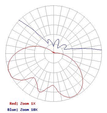 | ||||||||||||||||||
| Azimuth | Ratio | Azimuth | Ratio | Azimuth | Ratio | Azimuth | Ratio | ||||||||||||
| 0 | 0.015 | 10 | 0.026 | 20 | 0.031 | 30 | 0.018 | ||||||||||||
| 40 | 0.015 | 50 | 0.028 | 60 | 0.031 | 70 | 0.025 | ||||||||||||
| 80 | 0.060 | 90 | 0.138 | 100 | 0.272 | 110 | 0.439 | ||||||||||||
| 120 | 0.617 | 130 | 0.786 | 140 | 0.917 | 150 | 0.978 | ||||||||||||
| 160 | 0.972 | 170 | 0.857 | 180 | 0.671 | 190 | 0.733 | ||||||||||||
| 200 | 0.849 | 210 | 0.704 | 220 | 0.658 | 230 | 0.862 | ||||||||||||
| 240 | 0.991 | 250 | 1.000 | 260 | 0.929 | 270 | 0.788 | ||||||||||||
| 280 | 0.615 | 290 | 0.437 | 300 | 0.270 | 310 | 0.138 | ||||||||||||
| 320 | 0.060 | 330 | 0.026 | 340 | 0.031 | 350 | 0.024 | ||||||||||||
Structure Registration Number 1018045 Structure Type: GTOWER Registered To: American Towers LLC Structure Address: End Of Snider Ln (006510) Purcellville, VA County Name: Loudoun County ASR Issued: 06/30/2022 Date Built: 05/04/2009 Site Elevation: 392 m (1286 ft.) Structure Height: 72.8 m (239 ft.) Height Overall: 78 m (256 ft.) Overall Height AMSL: 470 m (1542 ft.) FAA Determination: 07/02/2014 FAA Study #: 2014-AEA-3483-OE FAA Circular #: 70/7460-1K Paint & Light FAA Chapters: 4, 8, 12 OM&L to remain the same as prior study = A MED-DUAL SYSTEM 39-17-43.9 N 77-42-13.7 W (NAD 83) 39-17-43.5 N 77-42-14.7 W (Converted to NAD 27) |
5670 Wilshire Blvd., #1620 Los Angeles, CA 90036 Phone: 323-904-4090 Limited Liability Company | Title: Manager Date: 08/03/2017 Application Certifier Wmtm, Llc 5670 Wilshire Blvd., #1620 Los Angeles, CA 90036 Applicant LAWRENCE ROGOW Wmtm, Llc 5670 Wilshire Blvd., #1620 Los Angeles, CA 90036 JOAN STEWART Wiley Rein Llp 1776 K Street Nw Washington, DC 20006 | |||||||||||||||||