
FCCInfo.com
A Service of Cavell, Mertz & Associates, Inc.
(855) FCC-INFO
|
|
DK39GG from 06/25/2002 |
|
|
||||||||||||||||
|
|
Status: License Application Accepted: 06/27/2018 License Expires: 04/01/2022 File Number: -0000055462 FCC Website Links: LMS Facility Details This Application Other DK39GG Applications Including Superseded Applications Mailing Address Correspondence for DK39GG Correspondence related to application -0000055462 Service Contour - Open Street Map or USGS Map (74 dBu) Service Contour - KML / Google Earth (74 dBu) Rabbit Ears Info Search for DK39GG Site Location: 46-32-05.1 N 93-50-16.0 W (NAD 83) Site Location: 46-32-05.2 N 93-50-15.1 W (Converted to NAD 27) ERP: 14.3 kW R/C AGL: 100 m (328 ft.) R/C AMSL: 470.9 m (1545 ft.) Site Elevation: 370.9 m. (1217 ft.) Height Overall*: 110 m (361 ft.) (* As Filed In This Application, may differ from ASR Data, Below.) Directional Antenna - Antenna Make/Model: Andrew ALP12L2-HSP Antenna ID: 16390 | ||||||||||||||||||
| Antenna Data for Antenna Id: 16390 DK39GG TX File: -0000055462 Andrew - ALP12L2-HSP Service: TX Standard Pattern: Y Pattern and Field Values Include a 355° Clockwise Rotation | 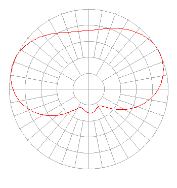 | ||||||||||||||||||
| Azimuth | Ratio | Azimuth | Ratio | Azimuth | Ratio | Azimuth | Ratio | ||||||||||||
| 5 | 0.738 | 15 | 0.777 | 25 | 0.835 | 35 | 0.898 | ||||||||||||
| 45 | 0.954 | 55 | 0.992 | 65 | 0.999 | 75 | 0.973 | ||||||||||||
| 85 | 0.918 | 95 | 0.832 | 105 | 0.716 | 115 | 0.584 | ||||||||||||
| 125 | 0.446 | 135 | 0.326 | 145 | 0.259 | 155 | 0.260 | ||||||||||||
| 165 | 0.289 | 175 | 0.305 | 185 | 0.289 | 195 | 0.260 | ||||||||||||
| 205 | 0.259 | 215 | 0.326 | 225 | 0.446 | 235 | 0.584 | ||||||||||||
| 245 | 0.716 | 255 | 0.832 | 265 | 0.918 | 275 | 0.973 | ||||||||||||
| 285 | 0.999 | 295 | 0.992 | 305 | 0.954 | 315 | 0.898 | ||||||||||||
| 325 | 0.835 | 335 | 0.777 | 345 | 0.738 | 355 | 0.728 | ||||||||||||
Structure Registration Number 1064589 Structure Type: Registered To: KQDS-TV Corp. Structure Address: Hwy 30 0.45 Mi W At Hwy 32 Rabbit Lake Twp, MN County Name: Crow Wing County ASR Issued: 01/26/2022 Date Built: 03/14/2002 Site Elevation: 370.9 m (1217 ft.) Structure Height: 109 m (358 ft.) Height Overall: 110 m (361 ft.) Overall Height AMSL: 480.9 m (1578 ft.) FAA Determination: 05/30/2002 FAA Study #: 02-AGL-1358-OE Paint & Light FAA Chapters: 1, 3, 12, 21 OM&L TO REMAIN PAINT RED LIGHTS 46-32-05.1 N 93-50-16.0 W (NAD 83) 46-32-05.2 N 93-50-15.1 W (Converted to NAD 27) |
P. O. Box 9115 Fargo, ND 58106 Phone: 701-277-1515 Corporation | Title: Chief Operating Officer Date: 06/27/2018 Application Certifier KQDS ACQUISITION CORP. Kqds Acquisition Corp. P. O. Box 9115 Fargo, ND 58106 Applicant CHRIS DROVDAL Kqds Acquisition Corporation Fargo, ND 58106 CHIEF ENGINEER CHARLES R. NAFTALIN, ESQ. Holland & Knight Llp 800 17th Street Nw, Suite 1100 Washington, DC 20006 FCC LEGAL COUNSEL | |||||||||||||||||