
FCCInfo.com
A Service of Cavell, Mertz & Associates, Inc.
(855) FCC-INFO
|
|
K12XJ-D from 02/23/2000 K12XJ-D from 12/02/1997 K12XJ-D from 03/04/1997 K12XJ-D from 01/29/1988 |
|
|
|||||||||||||||||
|
|
Status: License Application Accepted: 05/21/2020 License Expires: 12/01/2022 File Number: -0000114101 FCC Website Links: LMS Facility Details This Application Other K12XJ-D Applications Including Superseded Applications Mailing Address Correspondence for K12XJ-D Correspondence related to application -0000114101 Service Contour - Open Street Map or USGS Map (48 dBu) Service Contour - KML / Google Earth (48 dBu) Rabbit Ears Info Search for K12XJ-D Site Location: 37-38-59.4 N 121-01-27.3 W (NAD 83) Site Location: 37-38-59.7 N 121-01-23.5 W (Converted to NAD 27) ERP: 2 kW Polarization: Horizontally polarized R/C AGL: 82.6 m (271 ft.) R/C AMSL: 107.3 m (352 ft.) Emission Mask: Full Service Site Elevation: 24.7 m. (81 ft.) Height Overall*: 128.9 m (423 ft.) (* As Filed In This Application, may differ from ASR Data, Below.) Directional Antenna - Antenna Make/Model: Propagation System Inc VHDP-SL2-12 Antenna ID: Polarization: Horizontally polarized
| |||||||||||||||||||
| Antenna Data for Antenna Id: K12XJ-D LD File: -0000114101 Propagation System Inc - VHDP-SL2-12 Service: LD Standard Pattern: N Pattern and Field Values Include a 95.0° Clockwise Rotation | 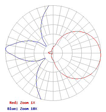 | |||||||||||||||||||
| Azimuth | Ratio | Azimuth | Ratio | Azimuth | Ratio | Azimuth | Ratio | |||||||||||||
| 5 | 0.136 | 15 | 0.167 | 25 | 0.334 | 35 | 0.492 | |||||||||||||
| 45 | 0.637 | 55 | 0.762 | 65 | 0.863 | 75 | 0.938 | |||||||||||||
| 85 | 0.984 | 95 | 1.000 | 105 | 0.984 | 115 | 0.938 | |||||||||||||
| 125 | 0.863 | 135 | 0.762 | 145 | 0.637 | 155 | 0.492 | |||||||||||||
| 165 | 0.334 | 175 | 0.167 | 185 | 0.136 | 195 | 0.100 | |||||||||||||
| 205 | 0.080 | 215 | 0.060 | 225 | 0.040 | 235 | 0.020 | |||||||||||||
| 245 | 0.040 | 255 | 0.060 | 265 | 0.080 | 275 | 0.100 | |||||||||||||
| 285 | 0.080 | 295 | 0.060 | 305 | 0.040 | 315 | 0.020 | |||||||||||||
| 325 | 0.040 | 335 | 0.060 | 345 | 0.080 | 355 | 0.100 | |||||||||||||
Structure Registration Number 1035104 Structure Type: LTOWER Registered To: American Towers LLC Structure Address: 1049 Lone Palm Ave. (#274901) Modesto, CA County Name: Stanislaus County ASR Issued: 04/11/2013 Date Built: 10/09/1999 Site Elevation: 24.7 m (81 ft.) Structure Height: 122.2 m (401 ft.) Height Overall: 128.9 m (423 ft.) Overall Height AMSL: 153.6 m (504 ft.) FAA Determination: 04/09/2013 FAA Study #: 2013-AWP-2050-OE FAA Circular #: 70/7460-1K Paint & Light FAA Chapters: 4, 6, 12 PRIOR STUDY 2011-AWP-8329-OE 37-38-59.4 N 121-01-27.3 W (NAD 83) 37-38-59.7 N 121-01-23.5 W (Converted to NAD 27) |
295 Madison Avenue, 12th Floor New York, NY 10017 Phone: 954-606-5486 Corporation | Title: Chief Operating Officer Date: 05/21/2020 Application Certifier Dtv America Corporation 450 Park Avenue 30th Floor New York, NY 10022 Applicant REBECCA HANSON Hc2 Broadcasting Holdings, Inc. 450 Park Avenue 30th Floor New York, NY 10022 EVP AND GENERAL COUNSEL KURT HANSON Hc2 Broadcasting Holdings, Inc. 450 Park Avenue 30th Floor New York, NY 10022 CHIEF TECHNICAL OFFICER RENEE ILHARDT Hc2 Broadcasting Holdings, Inc. 450 Park Ave 30th Floor New York, NY 10022 CORPORATE REPRESENTATIVE | ||||||||||||||||||