
FCCInfo.com
A Service of Cavell, Mertz & Associates, Inc.
(855) FCC-INFO
|
|
|
|
|
||||||||||||||||
|
|
Status: STA – Special Temporary Authority (Licensed And Silent) Application Accepted: 06/29/2021 STA Expires: 00/00/0000 File Number: -0000149470 FCC Website Links: LMS Facility Details This Application Other W48CL Applications Including Superseded Applications Mailing Address Correspondence for W48CL Correspondence related to application -0000149470 Service Contour - Open Street Map or USGS Map (74 dBu) Service Contour - KML / Google Earth (74 dBu) Rabbit Ears Info Search for W48CL Site Location: 43-00-59.3 N 85-44-24.2 W (NAD 83) Site Location: 43-00-59.2 N 85-44-24.1 W (Converted to NAD 27) ERP: 16.1 kW Polarization: Horizontally polarized R/C AGL: 94 m (308 ft.) R/C AMSL: 332 m (1089 ft.) Site Elevation: 238 m. (781 ft.) Height Overall*: 125.9 m (413 ft.) (* As Filed In This Application, may differ from ASR Data, Below.) Directional Antenna - Antenna Make/Model: Antenna Concepts Inc. ACS8C Antenna ID: 17792 Polarization: Horizontally polarized | ||||||||||||||||||
| Antenna Data for Antenna Id: 17792 W48CL TX File: -0000149470 Antenna Concepts Inc. - ACS8C Service: TX Standard Pattern: Y Pattern and Field Values Include a 125° Clockwise Rotation | 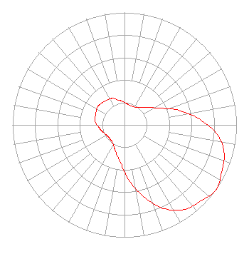 | ||||||||||||||||||
| Azimuth | Ratio | Azimuth | Ratio | Azimuth | Ratio | Azimuth | Ratio | ||||||||||||
| 5 | 0.190 | 15 | 0.180 | 25 | 0.180 | 35 | 0.190 | ||||||||||||
| 45 | 0.220 | 55 | 0.270 | 65 | 0.350 | 75 | 0.500 | ||||||||||||
| 85 | 0.660 | 95 | 0.820 | 105 | 0.920 | 115 | 0.960 | ||||||||||||
| 125 | 1.000 | 135 | 0.960 | 145 | 0.920 | 155 | 0.820 | ||||||||||||
| 165 | 0.660 | 175 | 0.500 | 185 | 0.350 | 195 | 0.270 | ||||||||||||
| 205 | 0.220 | 215 | 0.190 | 225 | 0.180 | 235 | 0.180 | ||||||||||||
| 245 | 0.190 | 255 | 0.210 | 265 | 0.230 | 275 | 0.260 | ||||||||||||
| 285 | 0.270 | 295 | 0.280 | 305 | 0.290 | 315 | 0.280 | ||||||||||||
| 325 | 0.270 | 335 | 0.260 | 345 | 0.230 | 355 | 0.210 | ||||||||||||
Structure Registration Number 1007106 Structure Type: GTOWER Registered To: SBA Towers II LLC Structure Address: 2853 Three Mile Road Nw (mi10597-a) Walker, MI County Name: Kent County ASR Issued: 05/30/2023 Date Built: 01/01/1991 Site Elevation: 238 m (781 ft.) Structure Height: 120.7 m (396 ft.) Height Overall: 125.9 m (413 ft.) Overall Height AMSL: 363.9 m (1194 ft.) FAA Determination: 12/08/2022 FAA Study #: 2022-AGL-1815-OE FAA Circular #: 70/7460-1K Paint & Light FAA Chapters: 4, 8, 12 OM&L to remain the same as prior study = A MED-DUAL SYSTEM 43-00-59.3 N 85-44-24.2 W (NAD 83) 43-00-59.2 N 85-44-24.1 W (Converted to NAD 27) |
Hurst, TX 76054 Phone: 214-770-7770 Corporation | Title: Ceo Date: 06/29/2021 Application Certifier EDGE SPECTRUM, INC. Edge Spectrum, Inc. Hurst, TX 76054 Applicant Caleb Weiss Ark Multicasting, Inc. Cedar Hill, TX 75106 President Randy Weiss Edge Spectrum, Inc. Hurst, TX 76054 CEO Susan Hansen B. W. St. Clair 2305 Vida Shaw Rd. New Iberia, LA 70563 Consultant | |||||||||||||||||