
FCCInfo.com
A Service of Cavell, Mertz & Associates, Inc.
(855) FCC-INFO
|
|
KCWF-LD from 09/24/2008 KCWF-LD from 03/22/2006 KCWF-LD from 12/19/2000 KCWF-LD from 12/30/1998 KCWF-LD from 08/21/1998 KCWF-LD from 07/30/1998 KCWF-LD from 03/17/1998 KCWF-LD from 10/16/1997 |
|
|
||||||||||||||||
|
|
Status: License Application Accepted: 12/07/2021 License Expires: 10/03/2022 File Number: -0000151687 FCC Website Links: LMS Facility Details This Application Other KCWF-LD Applications Including Superseded Applications Mailing Address Correspondence for KCWF-LD Correspondence related to application -0000151687 Service Contour - Open Street Map or USGS Map (51 dBu) Service Contour - KML / Google Earth (51 dBu) Rabbit Ears Info Search for KCWF-LD Site Location: 32-24-16.7 N 106-45-39.9 W (NAD 83) Site Location: 32-24-16.4 N 106-45-37.9 W (Converted to NAD 27) ERP: 1 kW Polarization: Elliptically polarized Electrical Beam Tilt: 1.0 degree R/C AGL: 26 m (85 ft.) R/C AMSL: 1494.8 m (4904 ft.) Emission Mask: Stringent Site Elevation: 1468.8 m. (4819 ft.) Height Overall*: 33.5 m (110 ft.) (* As Filed In This Application, may differ from ASR Data, Below.) Directional Antenna - Antenna Make/Model: Dielectric TLP-M/VP Antenna ID: 1008998 Polarization: Elliptically polarized | ||||||||||||||||||
| Antenna Data for Antenna Id: 1008998 KCWF-LD LD File: -0000151687 Dielectric - TLP-M/VP Service: LD Standard Pattern: N | 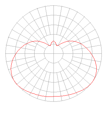 | ||||||||||||||||||
| Azimuth | Ratio | Azimuth | Ratio | Azimuth | Ratio | Azimuth | Ratio | ||||||||||||
| 0 | 0.257 | 10 | 0.227 | 20 | 0.183 | 24 | 0.178 | ||||||||||||
| 30 | 0.194 | 40 | 0.278 | 50 | 0.393 | 60 | 0.502 | ||||||||||||
| 70 | 0.599 | 80 | 0.688 | 90 | 0.778 | 100 | 0.873 | ||||||||||||
| 110 | 0.951 | 120 | 0.993 | 126 | 1.000 | 130 | 0.998 | ||||||||||||
| 140 | 0.976 | 150 | 0.944 | 160 | 0.918 | 170 | 0.901 | ||||||||||||
| 180 | 0.895 | 190 | 0.908 | 200 | 0.921 | 210 | 0.942 | ||||||||||||
| 220 | 0.974 | 230 | 0.995 | 234 | 0.996 | 240 | 0.985 | ||||||||||||
| 250 | 0.940 | 260 | 0.865 | 270 | 0.775 | 280 | 0.684 | ||||||||||||
| 290 | 0.593 | 300 | 0.497 | 310 | 0.392 | 320 | 0.280 | ||||||||||||
| 330 | 0.197 | 336 | 0.179 | 340 | 0.184 | 350 | 0.226 | ||||||||||||
Structure Registration Number 1037523 Structure Type: LTOWER Registered To: American Towers LLC Structure Address: 7651 N. Twin View Rd. (9063) Las Cruces, NM County Name: Do¤a Ana County ASR Issued: 08/13/2013 Date Built: 08/08/2013 Site Elevation: 1468.8 m (4819 ft.) Structure Height: 30.8 m (101 ft.) Height Overall: 33.5 m (110 ft.) Overall Height AMSL: 1502.3 m (4929 ft.) FAA Determination: 08/08/2013 FAA Study #: 2013-ASW-5138-OE Paint & Light FAA Chapters: NONE PRIOR STUDY 2004-ASW-4769-OE 32-24-16.7 N 106-45-39.9 W (NAD 83) 32-24-16.4 N 106-45-37.9 W (Converted to NAD 27) |
10706 Beaver Dam Road Cockeysville, MD 21030 Phone: 410-568-1500 Limited Liability Company | Title: Cfo Date: 12/07/2021 Application Certifier KDBC LICENSEE, LLC Kdbc Licensee, Llc 10706 Beaver Dam Road Cockeysville, MD 21030 Applicant John E. Hidle, PE Carl T. Jones Corporation 7901 Yarnwood Court Springfield, VA 22153 Consulting Engineer Paul A. Cicelski, Esq Lerman Senter Pllc 2001 L St. Nw Suite 400 Washington, DC 20036 | |||||||||||||||||