
FCCInfo.com
A Service of Cavell, Mertz & Associates, Inc.
(855) FCC-INFO
|
|
K20OM-D from 01/30/2012 |
|
|
||||||||||||||||
|
|
Status: Construction Permit Application Accepted: 11/26/2021 K20OM-D CP Expires: 12/02/2024 File Number: -0000171574 FCC Website Links: LMS Facility Details This Application Other K20OM-D Applications Including Superseded Applications Mailing Address Correspondence for K20OM-D Correspondence related to application -0000171574 Service Contour - Open Street Map or USGS Map (51 dBu) Service Contour - KML / Google Earth (51 dBu) Rabbit Ears Info Search for K20OM-D Site Location: 29-58-36.0 N 93-56-03.0 W (NAD 83) Site Location: 29-58-35.2 N 93-56-02.4 W (Converted to NAD 27) ERP: 5 kW Polarization: Elliptically polarized Electrical Beam Tilt: 1.5 degrees R/C AGL: 89 m (292 ft.) R/C AMSL: 92 m (302 ft.) Emission Mask: Full Service Site Elevation: 3 m. (10 ft.) Height Overall*: 152.4 m (500 ft.) (* As Filed In This Application, may differ from ASR Data, Below.) Directional Antenna - Antenna Make/Model: Antenna Concepts Inc. ACS8BR Antenna ID: 17791 Polarization: Elliptically polarized | ||||||||||||||||||
| Antenna Data for Antenna Id: 17791 K20OM-D LD File: -0000171574 Antenna Concepts Inc. - ACS8BR Service: LD Standard Pattern: Y Pattern and Field Values Include a 240° Clockwise Rotation | 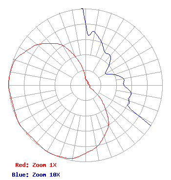 | ||||||||||||||||||
| Azimuth | Ratio | Azimuth | Ratio | Azimuth | Ratio | Azimuth | Ratio | ||||||||||||
| 0 | 0.080 | 10 | 0.070 | 20 | 0.060 | 30 | 0.050 | ||||||||||||
| 40 | 0.050 | 50 | 0.040 | 60 | 0.030 | 70 | 0.040 | ||||||||||||
| 80 | 0.050 | 90 | 0.050 | 100 | 0.060 | 110 | 0.060 | ||||||||||||
| 120 | 0.080 | 130 | 0.230 | 140 | 0.400 | 150 | 0.600 | ||||||||||||
| 160 | 0.710 | 170 | 0.820 | 180 | 0.890 | 190 | 0.970 | ||||||||||||
| 200 | 0.990 | 210 | 1.000 | 220 | 0.980 | 230 | 0.980 | ||||||||||||
| 240 | 1.000 | 250 | 0.980 | 260 | 0.980 | 270 | 1.000 | ||||||||||||
| 280 | 0.990 | 290 | 0.970 | 300 | 0.890 | 310 | 0.820 | ||||||||||||
| 320 | 0.710 | 330 | 0.600 | 340 | 0.400 | 350 | 0.230 | ||||||||||||
Structure Registration Number 1049415 Structure Type: TOWER Registered To: K2 Towers III, LLC Structure Address: 337 Pine St Port Neches, TX County Name: Jefferson County ASR Issued: 02/04/2022 Date Built: 01/01/1993 Site Elevation: 3 m (10 ft.) Structure Height: 146 m (479 ft.) Height Overall: 152.4 m (500 ft.) Overall Height AMSL: 155.4 m (510 ft.) FAA Determination: 11/30/1993 FAA Study #: 93-ASW-0170-OE FAA Circular #: 70/7460-1H Paint & Light FAA Chapters: 3, 4, 5, 13 29-58-36.0 N 93-56-03.0 W (NAD 83) 29-58-35.2 N 93-56-02.4 W (Converted to NAD 27) |
Hurst, TX 75054 Phone: 972-291-3750 Corporation | Title: Ceo Date: 11/26/2021 Application Certifier EDGE SPECTRUM, INC. Edge Spectrum, Inc. Hurst, TX 75054 Applicant Susan Hansen B. W. St. Clair 2305 Vida Shaw Rd. New Iberia, LA 70563 Consultant Caleb Weiss Ark Mediacom, Inc. Cedar Hill, TX 75106 President | |||||||||||||||||