
FCCInfo.com
A Service of Cavell, Mertz & Associates, Inc.
(855) FCC-INFO
|
|
K16AE-D from 03/05/1982 |
|
|
||||||||||||||||
|
|
Status: License Application Accepted: 12/03/2021 License Expires: 10/03/2022 File Number: -0000176753 FCC Website Links: LMS Facility Details This Application Other K16AE-D Applications Including Superseded Applications Mailing Address Correspondence for K16AE-D Correspondence related to application -0000176753 Service Contour - Open Street Map or USGS Map (51 dBu) Service Contour - KML / Google Earth (51 dBu) Rabbit Ears Info Search for K16AE-D Site Location: 44-18-17.0 N 105-33-55.0 W (NAD 83) Site Location: 44-18-17.1 N 105-33-53.0 W (Converted to NAD 27) ERP: 0.77 kW Polarization: Horizontally polarized R/C AGL: 14.6 m (48 ft.) R/C AMSL: 1506.3 m (4942 ft.) Emission Mask: Simple Site Elevation: 1491.7 m. (4894 ft.) Height Overall*: 21.3 m (70 ft.) (* As Filed In This Application, may differ from ASR Data, Below.) Directional Antenna - Antenna Make/Model: Scala 4DR-4S Antenna ID: 20748 Polarization: Horizontally polarized
| ||||||||||||||||||
| Antenna Data for Antenna Id: 20748 K16AE-D LD File: -0000176753 Scala - 4DR-4S Service: LD Standard Pattern: Y Pattern and Field Values Include a 110° Clockwise Rotation | 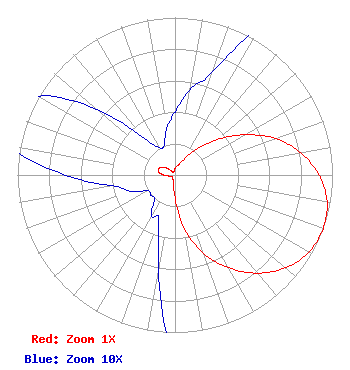 | ||||||||||||||||||
| Azimuth | Ratio | Azimuth | Ratio | Azimuth | Ratio | Azimuth | Ratio | ||||||||||||
| 0 | 0.040 | 10 | 0.055 | 20 | 0.070 | 30 | 0.115 | ||||||||||||
| 40 | 0.210 | 50 | 0.350 | 60 | 0.510 | 70 | 0.680 | ||||||||||||
| 80 | 0.810 | 90 | 0.915 | 100 | 0.980 | 110 | 1.000 | ||||||||||||
| 120 | 0.980 | 130 | 0.917 | 140 | 0.813 | 150 | 0.680 | ||||||||||||
| 160 | 0.530 | 170 | 0.350 | 180 | 0.140 | 190 | 0.060 | ||||||||||||
| 200 | 0.030 | 210 | 0.030 | 220 | 0.020 | 230 | 0.020 | ||||||||||||
| 240 | 0.020 | 250 | 0.030 | 260 | 0.040 | 270 | 0.070 | ||||||||||||
| 280 | 0.105 | 290 | 0.110 | 300 | 0.100 | 310 | 0.065 | ||||||||||||
| 320 | 0.030 | 330 | 0.020 | 340 | 0.020 | 350 | 0.030 | ||||||||||||
Structure Registration Number 1008911 Structure Type: TOWER Registered To: CENTRAL WYOMING COLLEGE DBA = WYOMING PUBLIC TELEVISION Structure Address: .67 Mi N Of I-90 1.75 Mi E Of Us 14 & 16 Gillette, WY County Name: Campbell County ASR Issued: 12/19/2006 Date Built: 01/13/1991 Site Elevation: 1491.7 m (4894 ft.) Structure Height: 15.2 m (50 ft.) Height Overall: 21.3 m (70 ft.) Overall Height AMSL: 1513 m (4964 ft.) FAA Determination: 12/08/1988 FAA Study #: 88-ANM-0295-OE FAA Circular #: 70/7460-1G Paint & Light FAA Chapters: 5, 9 44-18-17.0 N 105-33-55.0 W (NAD 83) 44-18-17.1 N 105-33-53.0 W (Converted to NAD 27) |
610 Peachtree Pkwy Suite 203 Cumming, GA 30041 Phone: 678-234-1271 Limited Liability Company | Title: Manager Date: 12/03/2021 Application Certifier BIG HORN TELEVISION LLC Bhtv License Llc 610 Peachtree Pkwy Suite 203 Cumming, GA 30041 Applicant Daniel Kirkpatrick, Esq Baker & Hostetler Llp 1050 Connecticut Ave., Nw Suite 1100 Washington, DC 20036 Erik C Swanson, PE Hatfield & Dawson 9500 Greenwood Ave N Seattle, WA 98103 Consulting Engineer | |||||||||||||||||