
FCCInfo.com
A Service of Cavell, Mertz & Associates, Inc.
(855) FCC-INFO
|
|
K15MY-D from 07/12/2011 |
|
|
|||||||||||||||||
|
|
Status: License Application Accepted: 01/07/2022 License Expires: 04/01/2030 File Number: -0000179251 FCC Website Links: LMS Facility Details This Application Other K15MY-D Applications Including Superseded Applications Mailing Address Correspondence for K15MY-D Correspondence related to application -0000179251 Service Contour - Open Street Map or USGS Map (51 dBu) Service Contour - KML / Google Earth (51 dBu) Rabbit Ears Info Search for K15MY-D Site Location: 44-04-00.0 N 103-15-03.0 W (NAD 83) Site Location: 44-04-00.0 N 103-15-01.3 W (Converted to NAD 27) ERP: 15 kW Polarization: Elliptically polarized Electrical Beam Tilt: 1.05 degrees R/C AGL: 143.3 m (470 ft.) R/C AMSL: 1275.9 m (4186 ft.) Emission Mask: Full Service Site Elevation: 1132.6 m. (3716 ft.) Height Overall*: 190.8 m (626 ft.) (* As Filed In This Application, may differ from ASR Data, Below.) Directional Antenna - Antenna Make/Model: Dielectric TFU-8WB-LP/VP-R Antenna ID: 1008574 Polarization: Elliptically polarized
| |||||||||||||||||||
| Antenna Data for Antenna Id: 1008574 K15MY-D LD File: -0000179251 Dielectric - TFU-8WB-LP/VP-R Service: LD Standard Pattern: N Pattern and Field Values Include a 90° Clockwise Rotation | 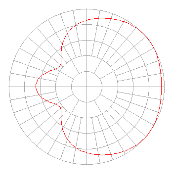 | |||||||||||||||||||
| Azimuth | Ratio | Azimuth | Ratio | Azimuth | Ratio | Azimuth | Ratio | |||||||||||||
| 0 | 0.849 | 10 | 0.889 | 20 | 0.926 | 30 | 0.961 | |||||||||||||
| 40 | 0.987 | 50 | 1.000 | 60 | 0.996 | 70 | 0.983 | |||||||||||||
| 80 | 0.969 | 90 | 0.963 | 100 | 0.968 | 110 | 0.982 | |||||||||||||
| 120 | 0.995 | 130 | 0.999 | 140 | 0.987 | 150 | 0.960 | |||||||||||||
| 160 | 0.926 | 170 | 0.888 | 180 | 0.848 | 190 | 0.795 | |||||||||||||
| 200 | 0.720 | 210 | 0.619 | 220 | 0.508 | 230 | 0.435 | |||||||||||||
| 240 | 0.453 | 250 | 0.538 | 260 | 0.619 | 270 | 0.651 | |||||||||||||
| 280 | 0.619 | 290 | 0.537 | 300 | 0.453 | 310 | 0.436 | |||||||||||||
| 320 | 0.510 | 330 | 0.622 | 340 | 0.723 | 350 | 0.798 | |||||||||||||
Structure Registration Number 1042276 Structure Type: TOWER Registered To: Gray Media Group, Inc. Structure Address: 2000 Skyline Dr Rapid City, SD County Name: Pennington County ASR Issued: 09/09/2020 Date Built: 01/01/1976 Site Elevation: 1132.6 m (3716 ft.) Structure Height: 167.6 m (550 ft.) Height Overall: 190.8 m (626 ft.) Overall Height AMSL: 1323.4 m (4342 ft.) FAA Determination: 03/12/1976 FAA Study #: 73-RM-140-OE Paint & Light FAA Chapters: 1, 3, 5, 14, 21 RED LIGHTS/PAINT 44-04-00.0 N 103-15-03.0 W (NAD 83) 44-04-00.0 N 103-15-01.3 W (Converted to NAD 27) |
4370 Peachtree Road, Ne Atlanta, GA 30319 Phone: 404-266-8333 Limited Liability Company | Title: Assistant Secretary Date: 01/07/2022 Application Certifier Gray Television Licensee, LLC Gray Television Licensee, Llc 4370 Peachtree Road, Ne Atlanta, GA 30319 Applicant Joan Stewart Wiley Rein Llp 2050 M Street, Nw Washington, DC 20036 | ||||||||||||||||||