
FCCInfo.com
A Service of Cavell, Mertz & Associates, Inc.
(855) FCC-INFO
|
|
|
|
|
||||||||||||||||
|
|
Status: License Application Accepted: 01/26/2022 License Expires: 02/01/2022 File Number: -0000181605 FCC Website Links: LMS Facility Details This Application Other KRMS-LD Applications Including Superseded Applications Mailing Address Correspondence for KRMS-LD Correspondence related to application -0000181605 Service Contour - Open Street Map or USGS Map (51 dBu) Service Contour - KML / Google Earth (51 dBu) Rabbit Ears Info Search for KRMS-LD Site Location: 38-09-52.1 N 92-36-12.6 W (NAD 83) Site Location: 38-09-52.0 N 92-36-11.9 W (Converted to NAD 27) ERP: 15 kW Polarization: Elliptically polarized Electrical Beam Tilt: .5 degrees R/C AGL: 115.8 m (380 ft.) R/C AMSL: 370.6 m (1216 ft.) Emission Mask: Stringent Site Elevation: 254.8 m. (836 ft.) Height Overall*: 157.9 m (518 ft.) (* As Filed In This Application, may differ from ASR Data, Below.) Directional Antenna - Antenna Make/Model: ALIVE TELECOM ATC-BCH78M-32 Antenna ID: 1008602 Polarization: Elliptically polarized | ||||||||||||||||||
| Antenna Data for Antenna Id: 1008602 KRMS-LD LD File: -0000181605 ALIVE TELECOM - ATC-BCH78M-32 Service: LD Standard Pattern: Y | 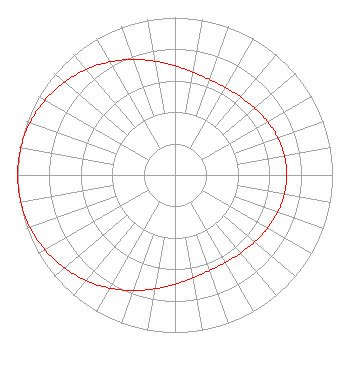 | ||||||||||||||||||
| Azimuth | Ratio | Azimuth | Ratio | Azimuth | Ratio | Azimuth | Ratio | ||||||||||||
| 0 | 0.694 | 10 | 0.663 | 20 | 0.645 | 30 | 0.641 | ||||||||||||
| 40 | 0.647 | 50 | 0.661 | 60 | 0.679 | 70 | 0.694 | ||||||||||||
| 80 | 0.705 | 90 | 0.709 | 100 | 0.705 | 110 | 0.694 | ||||||||||||
| 120 | 0.678 | 130 | 0.661 | 140 | 0.647 | 150 | 0.641 | ||||||||||||
| 160 | 0.645 | 170 | 0.663 | 180 | 0.694 | 190 | 0.734 | ||||||||||||
| 200 | 0.781 | 210 | 0.829 | 220 | 0.876 | 230 | 0.918 | ||||||||||||
| 240 | 0.953 | 250 | 0.979 | 260 | 0.995 | 270 | 1.000 | ||||||||||||
| 280 | 0.995 | 290 | 0.979 | 300 | 0.953 | 310 | 0.918 | ||||||||||||
| 320 | 0.876 | 330 | 0.829 | 340 | 0.781 | 350 | 0.734 | ||||||||||||
Structure Registration Number 1040883 Structure Type: TOWER Registered To: Global Tower, LLC. through American Towers, LLC Structure Address: 0.7 Kilometers North Osage Beach, MO County Name: Miller County ASR Issued: 08/29/2014 Date Built: 08/24/1998 Site Elevation: 254.8 m (836 ft.) Structure Height: 151.2 m (496 ft.) Height Overall: 157.9 m (518 ft.) Overall Height AMSL: 412.7 m (1354 ft.) FAA Determination: 05/01/2002 FAA Study #: 02-ace-83-oe FAA Circular #: 70/7460-1K Paint & Light FAA Chapters: 4, 6, 12 38-09-52.1 N 92-36-12.6 W (NAD 83) 38-09-52.0 N 92-36-11.9 W (Converted to NAD 27) |
5715 Osage Beach Parkway P.o. Box 225 Osage Beach, MO 65065 Phone: 573-692-5716 Corporation | Title: President Date: 01/26/2022 Application Certifier Viper Communications, Inc. 5715 Osage Beach Parkway P.o. Box 225 Osage Beach, MO 65065 Applicant Ken Kuenzie Viper Communications, Inc. 5715 Osage Beach Parkway P.o. Box 225 Osage Beach, MO 65065 President Dennis Wallace Meintel, Sgrignoli, & Wallace, Llc 1282 Smallwood Drive Suite 372 Waldorf, MD 20603 Technical Consultant | |||||||||||||||||