
FCCInfo.com
A Service of Cavell, Mertz & Associates, Inc.
(855) FCC-INFO
|
|
WCTD-LD from 05/31/2006 WCTD-LD from 06/23/2004 |
|
|
||||||||||||||||
|
|
Status: License Application Accepted: 02/24/2022 License Expires: 08/02/2021 File Number: -0000185309 FCC Website Links: LMS Facility Details This Application Other WCTD-LD Applications Including Superseded Applications Mailing Address Correspondence for WCTD-LD Correspondence related to application -0000185309 Service Contour - Open Street Map or USGS Map (51 dBu) Service Contour - KML / Google Earth (51 dBu) Rabbit Ears Info Search for WCTD-LD Site Location: 34-37-09.2 N 84-22-58.6 W (NAD 83) Site Location: 34-37-08.9 N 84-22-58.9 W (Converted to NAD 27) ERP: 10.5 kW Polarization: Horizontally polarized R/C AGL: 78 m (256 ft.) R/C AMSL: 602.5 m (1977 ft.) Emission Mask: Full Service Site Elevation: 524.5 m. (1721 ft.) Height Overall*: 79.6 m (261 ft.) (* As Filed In This Application, may differ from ASR Data, Below.) Directional Antenna - Antenna Make/Model: Scala (2) PR-450CU SPECIAL Antenna ID: 106426 Polarization: Horizontally polarized | ||||||||||||||||||
| Antenna Data for Antenna Id: 106426 WCTD-LD LD File: -0000185309 Scala - (2) PR-450CU SPECIAL Service: LD Standard Pattern: Y | 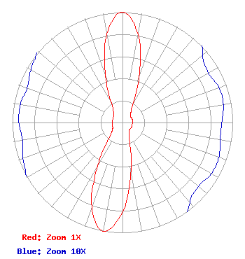 | ||||||||||||||||||
| Azimuth | Ratio | Azimuth | Ratio | Azimuth | Ratio | Azimuth | Ratio | ||||||||||||
| 0 | 1.000 | 10 | 0.812 | 20 | 0.444 | 30 | 0.188 | ||||||||||||
| 40 | 0.117 | 50 | 0.095 | 60 | 0.090 | 70 | 0.093 | ||||||||||||
| 80 | 0.093 | 90 | 0.090 | 100 | 0.090 | 110 | 0.093 | ||||||||||||
| 120 | 0.093 | 130 | 0.090 | 140 | 0.095 | 150 | 0.117 | ||||||||||||
| 160 | 0.188 | 170 | 0.444 | 180 | 0.812 | 190 | 1.000 | ||||||||||||
| 200 | 0.815 | 210 | 0.448 | 220 | 0.198 | 230 | 0.127 | ||||||||||||
| 240 | 0.102 | 250 | 0.096 | 260 | 0.092 | 270 | 0.094 | ||||||||||||
| 280 | 0.094 | 290 | 0.092 | 300 | 0.096 | 310 | 0.102 | ||||||||||||
| 320 | 0.127 | 330 | 0.198 | 340 | 0.448 | 350 | 0.815 | ||||||||||||
Structure Registration Number 1229068 Structure Type: LTOWER Registered To: American Towers LLC Structure Address: 514 Diamond Lure Road (022193 / Cartecay) Ellijay, GA County Name: Gilmer County ASR Issued: 06/24/2016 Date Built: 09/21/2001 Site Elevation: 524.5 m (1721 ft.) Structure Height: 76.5 m (251 ft.) Height Overall: 79.6 m (261 ft.) Overall Height AMSL: 604.1 m (1982 ft.) FAA Determination: 07/02/2012 FAA Study #: 2012-ASO-6019-OE FAA Circular #: 70/7460-1K Paint & Light FAA Chapters: 4, 8, 12 PRIOR STUDY 2003-ASO-1716-OE 34-37-09.2 N 84-22-58.6 W (NAD 83) 34-37-08.9 N 84-22-58.9 W (Converted to NAD 27) |
3901 Highway 121 South Bedford, TX 76021 Phone: 817-571-1229 Not-for-Profit | Title: Manager Date: 02/24/2022 Application Certifier WORD OF GOD FELLOWSHIP, INC. Word Of God Fellowship, Inc. 3901 Highway 121 South Bedford, TX 76021 Applicant RICHARD C. GOETZ Rl Media Systems 135 N Country Club Dr Hendersonville, TN 37075 BROADCAST CONSULTANT Robert L. Olender, Esq. Koerner & Olender P.c. 7020 Richard Drive Bethesda, MD 20817 LEGAL REPRESENTATIVE | |||||||||||||||||