
FCCInfo.com
A Service of Cavell, Mertz & Associates, Inc.
(855) FCC-INFO
|
|
WGBP-TV from 06/16/2005 WGBP-TV from 06/07/1982 WGBP-TV from 02/25/1980 |
Post-repack Channel 17 Virtual Channel 66 |  |
|
|||||||||||||||
|
|
Repacking Information: Pre-Repack Channel: 30 Post-Repack Channel: 17 Post-Repack ERP: 372 kW Phase: 1 Completion Deadline: 11/30/2018 Upstream/Downstream Dependencies Other Linked Stations Find nearby TV Facilities Status: Application Application Accepted: 10/17/2023 License Expires: 04/01/2021 File Number: -0000194947 FCC Website Links: LMS Facility Details This Application Other WGBP-TV Applications Including Superseded Applications Mailing Address Correspondence for WGBP-TV Correspondence related to application -0000194947 Service Contour - Open Street Map or USGS Map (41 dBu) Service Contour - KML / Google Earth (41 dBu) Public Inspection Files Rabbit Ears Info Search for WGBP-TV DTS Site Number: 1 Site Location: 32-19-16.4 N 84-47-28.2 W (NAD 83) Site Location: 32-19-15.9 N 84-47-28.5 W (Converted to NAD 27) ERP: 550 kW Polarization: Horizontally polarized HAAT: 537 m (1762 ft.) Electrical Beam Tilt: 1 degree R/C AGL: 508.8 m (1669 ft.) R/C AMSL: 656 m (2152 ft.) Site Elevation: 147.2 m. (483 ft.) Height Overall*: 538.2 m (1766 ft.) (* As Filed In This Application, may differ from ASR Data, Below.) Directional Antenna - Antenna Make/Model: MICRO COMMUNICATIONS INC 955316 Antenna ID: 1009782 Polarization: Horizontally polarized | ||||||||||||||||||
| Antenna Data for Antenna Id: 1009782 WGBP-TV DD File: -0000194947 MICRO COMMUNICATIONS INC - 955316 Service: DD Standard Pattern: N | 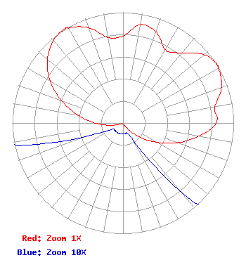 | ||||||||||||||||||
| Azimuth | Ratio | Azimuth | Ratio | Azimuth | Ratio | Azimuth | Ratio | ||||||||||||
| 0 | 0.785 | 10 | 0.902 | 20 | 0.873 | 30 | 0.763 | ||||||||||||
| 40 | 0.824 | 50 | 0.958 | 58 | 1.000 | 60 | 0.993 | ||||||||||||
| 70 | 0.948 | 80 | 0.843 | 90 | 0.843 | 100 | 0.694 | ||||||||||||
| 110 | 0.520 | 120 | 0.346 | 130 | 0.193 | 140 | 0.079 | ||||||||||||
| 150 | 0.019 | 160 | 0.010 | 170 | 0.010 | 180 | 0.010 | ||||||||||||
| 190 | 0.010 | 200 | 0.010 | 210 | 0.010 | 220 | 0.010 | ||||||||||||
| 230 | 0.010 | 240 | 0.012 | 250 | 0.036 | 260 | 0.119 | ||||||||||||
| 270 | 0.250 | 280 | 0.414 | 290 | 0.591 | 300 | 0.758 | ||||||||||||
| 310 | 0.891 | 320 | 0.974 | 328 | 1.000 | 330 | 0.989 | ||||||||||||
| 340 | 0.916 | 350 | 0.786 | ||||||||||||||||
Structure Registration Number 1243417 Structure Type: GTOWER Registered To: American Towers LLC Structure Address: 135 Hwy. 26 Cusseta, GA County Name: Chattahoochee County ASR Issued: 04/22/2015 Date Built: 10/06/2005 Site Elevation: 147.2 m (483 ft.) Structure Height: 500.7 m (1643 ft.) Height Overall: 538.2 m (1766 ft.) Overall Height AMSL: 685.4 m (2249 ft.) FAA Determination: 06/29/2007 FAA Study #: 2007-ASO-2952-OE FAA Circular #: 70/7460-1K Paint & Light FAA Chapters: 4, 9, 12 OM&L to remain the same as prior study = A HIGH-DUAL SYSTEM 32-19-16.4 N 84-47-28.2 W (NAD 83) 32-19-15.9 N 84-47-28.5 W (Converted to NAD 27) |
15200 Sunset Blvd Suite 202 Pacific Palisades, CA 90272 Phone: 310-573-1600 Limited Liability Company | Title: Manager Date: 07/13/2022 Application Certifier Cnz Communications Se, Llc 15200 Sunset Blvd Suite 202 Pacific Palisades, CA 90272 Applicant Kathleen Kirby Wiley Rein Llp 2050 M Street, Nw Washington, DC 20036 Greg Best Greg Best Consulting Inc 16100 Outlook Ave Stilwell, KS 66085 Consulting Engineer | |||||||||||||||||