
FCCInfo.com
A Service of Cavell, Mertz & Associates, Inc.
(855) FCC-INFO
|
|
|
|
|
||||||||||||||||
|
|
Status: Construction Permit Application Accepted: 07/27/2022 K30LK-D CP Expires: 09/06/2022 File Number: -0000195846 FCC Website Links: LMS Facility Details This Application Other K30LK-D Applications Including Superseded Applications Mailing Address Correspondence for K30LK-D Correspondence related to application -0000195846 Service Contour - Open Street Map or USGS Map (51 dBu) Service Contour - KML / Google Earth (51 dBu) Rabbit Ears Info Search for K30LK-D Site Location: 38-46-47.6 N 97-36-41.0 W (NAD 83) Site Location: 38-46-47.6 N 97-36-39.9 W (Converted to NAD 27) ERP: 0.1 kW Polarization: Horizontally polarized R/C AGL: 6 m (20 ft.) R/C AMSL: 386 m (1266 ft.) Emission Mask: Simple Site Elevation: 380 m. (1247 ft.) Height Overall*: 53 m (174 ft.) (* As Filed In This Application, may differ from ASR Data, Below.) Directional Antenna - Antenna Make/Model: Sam SAMCO160 Antenna ID: 1009817 Polarization: Horizontally polarized | ||||||||||||||||||
| Antenna Data for Antenna Id: 1009817 K30LK-D LD File: -0000195846 Sam - SAMCO160 Service: LD Standard Pattern: Y | 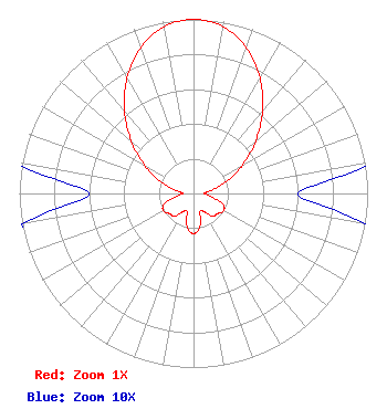 | ||||||||||||||||||
| Azimuth | Ratio | Azimuth | Ratio | Azimuth | Ratio | Azimuth | Ratio | ||||||||||||
| 0 | 1.000 | 10 | 0.973 | 20 | 0.888 | 30 | 0.764 | ||||||||||||
| 40 | 0.617 | 50 | 0.465 | 60 | 0.325 | 70 | 0.208 | ||||||||||||
| 80 | 0.108 | 90 | 0.060 | 100 | 0.100 | 110 | 0.180 | ||||||||||||
| 120 | 0.200 | 130 | 0.180 | 140 | 0.170 | 150 | 0.120 | ||||||||||||
| 160 | 0.110 | 170 | 0.200 | 180 | 0.230 | 190 | 0.200 | ||||||||||||
| 200 | 0.110 | 210 | 0.120 | 220 | 0.170 | 230 | 0.180 | ||||||||||||
| 240 | 0.200 | 250 | 0.180 | 260 | 0.100 | 270 | 0.060 | ||||||||||||
| 280 | 0.108 | 290 | 0.208 | 300 | 0.325 | 310 | 0.465 | ||||||||||||
| 320 | 0.617 | 330 | 0.764 | 340 | 0.888 | 350 | 0.973 | ||||||||||||
Structure Registration Number 1023021 Structure Type: TOWER Registered To: American Towers LLC Structure Address: 167 East Avenue "a" Salina, KS County Name: Saline County ASR Issued: 12/09/2016 Date Built: 03/13/2000 Site Elevation: 380 m (1247 ft.) Structure Height: 47.5 m (156 ft.) Height Overall: 53 m (174 ft.) Overall Height AMSL: 433 m (1421 ft.) FAA Determination: 06/07/2001 FAA Study #: 01-ACE-1122-OE Paint & Light FAA Chapters: NONE PRIOR STUDY 00-ACE-2430-OE 38-46-47.6 N 97-36-41.0 W (NAD 83) 38-46-47.6 N 97-36-39.9 W (Converted to NAD 27) |
Hurst, TX 76054 Phone: 214-770-7770 Corporation | Title: Ceo Date: 07/27/2022 Application Certifier EDGE SPECTRUM, INC. Edge Spectrum, Inc. Hurst, TX 76054 Applicant Josh Weiss Ark Multicasting, Inc.. Cedar Hill, TX 75106 CEO Susan Hansen B. W. St. Clair 2305 Vida Shaw Rd. New Iberia, LA 70563 Consultant Ari Meltzer Wiley Rein Llp 2050 M St Nw Washington, VA 22192 Caleb Weiss Ark Multicasting, Inc. Cedar Hill, TX 75106 President Randy Weiss Edge Spectrum, Inc. Hurst, TX 76054 CEO | |||||||||||||||||