
FCCInfo.com
A Service of Cavell, Mertz & Associates, Inc.
(855) FCC-INFO
|
|
|
|
|
||||||||||||||||
|
|
Status: License Application Accepted: 08/09/2022 License Expires: 08/01/2030 File Number: -0000197211 FCC Website Links: LMS Facility Details This Application Other K36LD-D Applications Including Superseded Applications Mailing Address Correspondence for K36LD-D Correspondence related to application -0000197211 Service Contour - Open Street Map or USGS Map (51 dBu) Service Contour - KML / Google Earth (51 dBu) Rabbit Ears Info Search for K36LD-D Site Location: 30-39-39.7 N 96-25-00.1 W (NAD 83) Site Location: 30-39-39.0 N 96-24-59.2 W (Converted to NAD 27) ERP: 15 kW Polarization: Elliptically polarized R/C AGL: 82.3 m (270 ft.) R/C AMSL: 171.9 m (564 ft.) Emission Mask: Full Service Site Elevation: 89.6 m. (294 ft.) Height Overall*: 150.3 m (493 ft.) (* As Filed In This Application, may differ from ASR Data, Below.) Directional Antenna - Antenna Make/Model: DIELECTRIC TLP-16B/VP Antenna ID: 1008649 Polarization: Elliptically polarized | ||||||||||||||||||
| Antenna Data for Antenna Id: 1008649 K36LD-D LD File: -0000197211 DIELECTRIC - TLP-16B/VP Service: LD Standard Pattern: Y Pattern and Field Values Include a 330° Clockwise Rotation | 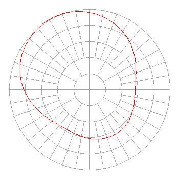 | ||||||||||||||||||
| Azimuth | Ratio | Azimuth | Ratio | Azimuth | Ratio | Azimuth | Ratio | ||||||||||||
| 0 | 0.955 | 10 | 0.920 | 20 | 0.876 | 30 | 0.826 | ||||||||||||
| 40 | 0.771 | 50 | 0.715 | 60 | 0.661 | 70 | 0.615 | ||||||||||||
| 80 | 0.583 | 90 | 0.569 | 100 | 0.571 | 110 | 0.586 | ||||||||||||
| 120 | 0.607 | 130 | 0.627 | 140 | 0.640 | 150 | 0.645 | ||||||||||||
| 160 | 0.641 | 170 | 0.631 | 180 | 0.614 | 190 | 0.592 | ||||||||||||
| 200 | 0.579 | 210 | 0.570 | 220 | 0.579 | 230 | 0.610 | ||||||||||||
| 240 | 0.650 | 250 | 0.699 | 260 | 0.759 | 270 | 0.818 | ||||||||||||
| 280 | 0.869 | 290 | 0.915 | 300 | 0.951 | 310 | 0.975 | ||||||||||||
| 320 | 0.993 | 330 | 1.000 | 340 | 0.996 | 350 | 0.981 | ||||||||||||
Structure Registration Number 1047729 Structure Type: Registered To: American Towers LLC Structure Address: 4717 Hwy 21 West (bryan 2 #4040) Bryan, TX County Name: Brazos County ASR Issued: 06/22/2016 Date Built: 01/27/2010 Site Elevation: 89.6 m (294 ft.) Structure Height: 146.3 m (480 ft.) Height Overall: 150.3 m (493 ft.) Overall Height AMSL: 239.9 m (787 ft.) FAA Determination: 10/20/2009 FAA Study #: 2009-ASW-3365-OE FAA Circular #: 70/7460-1K Paint & Light FAA Chapters: 4, 8, 12 PRIOR STUDY 2004-ASW-4597-OE 30-39-39.7 N 96-25-00.1 W (NAD 83) 30-39-39.0 N 96-24-59.2 W (Converted to NAD 27) |
Hurst, TX 76054 Phone: 214-770-7770 Corporation | Title: Ceo Date: 08/09/2022 Application Certifier EDGE SPECTRUM, INC. Edge Spectrum, Inc. Hurst, TX 76054 Applicant Susan Hansen B. W. St. Clair 2305 Vida Shaw Rd. New Iberia, LA 70563 Consultant Ari Meltzer Wiley Rein Llp 2050 M Street Nw Washington, DC 20036 Josh Weiss Ark Multicasting, Inc. Cedar Hill, TX 75106 CEO Randy Weiss Edge Spectrum, Inc. Hurst, TX 76054 CEO Caleb Weiss Ark Multicasting, Inc. Cedar Hill, TX 75106 President | |||||||||||||||||
