
FCCInfo.com
A Service of Cavell, Mertz & Associates, Inc.
(855) FCC-INFO
|
|
|
|
|
||||||||||||||||
|
|
Status: License Application Accepted: 08/22/2022 License Expires: 04/02/2029 File Number: -0000197999 FCC Website Links: LMS Facility Details This Application Other W20DL-D Applications Including Superseded Applications Mailing Address Correspondence for W20DL-D Correspondence related to application -0000197999 Service Contour - Open Street Map or USGS Map (51 dBu) Service Contour - KML / Google Earth (51 dBu) Rabbit Ears Info Search for W20DL-D Site Location: 32-50-28.5 N 83-40-17.2 W (NAD 83) Site Location: 32-50-28.0 N 83-40-17.5 W (Converted to NAD 27) ERP: 0.1 kW Polarization: Horizontally polarized R/C AGL: 6 m (20 ft.) R/C AMSL: 139.5 m (458 ft.) Emission Mask: Simple Site Elevation: 133.5 m. (438 ft.) Height Overall*: 195.1 m (640 ft.) (* As Filed In This Application, may differ from ASR Data, Below.) Directional Antenna - Antenna Make/Model: Sam SAMCO160 Antenna ID: 1009817 Polarization: Horizontally polarized | ||||||||||||||||||
| Antenna Data for Antenna Id: 1009817 W20DL-D LD File: -0000197999 Sam - SAMCO160 Service: LD Standard Pattern: Y Pattern and Field Values Include a 90° Clockwise Rotation | 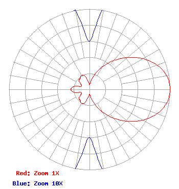 | ||||||||||||||||||
| Azimuth | Ratio | Azimuth | Ratio | Azimuth | Ratio | Azimuth | Ratio | ||||||||||||
| 0 | 0.060 | 10 | 0.108 | 20 | 0.208 | 30 | 0.325 | ||||||||||||
| 40 | 0.465 | 50 | 0.617 | 60 | 0.764 | 70 | 0.888 | ||||||||||||
| 80 | 0.973 | 90 | 1.000 | 100 | 0.973 | 110 | 0.888 | ||||||||||||
| 120 | 0.764 | 130 | 0.617 | 140 | 0.465 | 150 | 0.325 | ||||||||||||
| 160 | 0.208 | 170 | 0.108 | 180 | 0.060 | 190 | 0.100 | ||||||||||||
| 200 | 0.180 | 210 | 0.200 | 220 | 0.180 | 230 | 0.170 | ||||||||||||
| 240 | 0.120 | 250 | 0.110 | 260 | 0.200 | 270 | 0.230 | ||||||||||||
| 280 | 0.200 | 290 | 0.110 | 300 | 0.120 | 310 | 0.170 | ||||||||||||
| 320 | 0.180 | 330 | 0.200 | 340 | 0.180 | 350 | 0.100 | ||||||||||||
Structure Registration Number 1018922 Structure Type: GTOWER Registered To: American Towers LLC Structure Address: 667 Bartley St (026114 / Macon Downtown I) Macon, GA County Name: Bibb County ASR Issued: 02/27/2018 Date Built: 01/01/1993 Site Elevation: 133.5 m (438 ft.) Structure Height: 189.9 m (623 ft.) Height Overall: 195.1 m (640 ft.) Overall Height AMSL: 328.6 m (1078 ft.) FAA Determination: 02/23/2018 FAA Study #: 2018-ASO-1018-OE FAA Circular #: 70/7460-1L Paint & Light FAA Chapters: 4, 8, 12 PRIOR STUDY 2006-ASO-2123-OE 32-50-28.5 N 83-40-17.2 W (NAD 83) 32-50-28.0 N 83-40-17.5 W (Converted to NAD 27) |
Hurst, TX 76054 Phone: 214-770-7770 Corporation | Title: Ceo Date: 08/22/2022 Application Certifier EDGE SPECTRUM, INC. Edge Spectrum, Inc. Hurst, TX 76054 Applicant Susan Hansen B. W. St. Clair 2305 Vida Shaw Rd. New Iberia, LA 70563 Consultant Ari Meltzer Wiley Rein Llp 2050 M Street, Nw Washington, DC 20036 Caleb Weiss Ark Multicasting, Inc. Cedar Hill, TX 75106 President Randy Weiss Edge Spectrum, Inc. Hurst, TX 76054 CEO | |||||||||||||||||