
FCCInfo.com
A Service of Cavell, Mertz & Associates, Inc.
(855) FCC-INFO
|
|
W27EE-D from 08/13/2007 |
|
|
||||||||||||||||
|
|
Status: License Application Accepted: 11/22/2022 License Expires: 10/02/2028 File Number: -0000204148 FCC Website Links: LMS Facility Details This Application Other W27EE-D Applications Including Superseded Applications Mailing Address Correspondence for W27EE-D Correspondence related to application -0000204148 Service Contour - Open Street Map or USGS Map (51 dBu) Service Contour - KML / Google Earth (51 dBu) Rabbit Ears Info Search for W27EE-D Site Location: 39-27-36.2 N 78-03-44.7 W (NAD 83) Site Location: 39-27-35.8 N 78-03-45.7 W (Converted to NAD 27) ERP: 15 kW Polarization: Elliptically polarized Electrical Beam Tilt: 1.0 degree R/C AGL: 47.2 m (155 ft.) R/C AMSL: 497.7 m (1633 ft.) Emission Mask: Full Service Site Elevation: 450.5 m. (1478 ft.) Height Overall*: 97.5 m (320 ft.) (* As Filed In This Application, may differ from ASR Data, Below.) Directional Antenna - Antenna Make/Model: Propagation System Inc PSILP12DH-27-EP Antenna ID: 1010264 Polarization: Elliptically polarized
| ||||||||||||||||||
| Antenna Data for Antenna Id: 1010264 W27EE-D LD File: -0000204148 Propagation System Inc - PSILP12DH-27-EP Service: LD Standard Pattern: N Pattern and Field Values Include a 270° Clockwise Rotation | 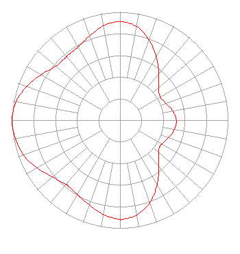 | ||||||||||||||||||
| Azimuth | Ratio | Azimuth | Ratio | Azimuth | Ratio | Azimuth | Ratio | ||||||||||||
| 0 | 0.911 | 10 | 0.880 | 20 | 0.788 | 30 | 0.673 | ||||||||||||
| 40 | 0.560 | 50 | 0.467 | 60 | 0.430 | 70 | 0.452 | ||||||||||||
| 80 | 0.495 | 90 | 0.521 | 92 | 0.522 | 100 | 0.511 | ||||||||||||
| 110 | 0.477 | 120 | 0.446 | 125 | 0.444 | 130 | 0.468 | ||||||||||||
| 140 | 0.560 | 150 | 0.688 | 160 | 0.810 | 170 | 0.891 | ||||||||||||
| 179 | 0.918 | 180 | 0.918 | 190 | 0.885 | 200 | 0.834 | ||||||||||||
| 210 | 0.793 | 218 | 0.776 | 220 | 0.777 | 230 | 0.816 | ||||||||||||
| 240 | 0.885 | 250 | 0.949 | 260 | 0.984 | 270 | 1.000 | ||||||||||||
| 280 | 0.977 | 290 | 0.917 | 300 | 0.842 | 310 | 0.776 | ||||||||||||
| 316 | 0.768 | 320 | 0.768 | 330 | 0.779 | 340 | 0.828 | ||||||||||||
| 350 | 0.885 | ||||||||||||||||||
Structure Registration Number 1282650 Structure Type: TOWER Registered To: West Virginia Emergency Management Division Structure Address: 4 Mi E Of Martinsburg, Wv Martinsburg, WV County Name: Berkeley County ASR Issued: 01/17/2024 Date Built: 08/08/2013 Site Elevation: 450.5 m (1478 ft.) Structure Height: 91.4 m (300 ft.) Height Overall: 97.5 m (320 ft.) Overall Height AMSL: 548 m (1798 ft.) FAA Determination: 01/23/2012 FAA Study #: 2011-AEA-5058-OE FAA Circular #: 70/7460-1K Paint & Light FAA Chapters: 4, 8, 12 Removed expiration date from determination. Scenario 1./jjs/case#635066 39-27-36.2 N 78-03-44.7 W (NAD 83) 39-27-35.8 N 78-03-45.7 W (Converted to NAD 27) |
600 Capitol Street Charleston, WV 25301 Phone: 304-556-4903 Government Entity | Title: Executive Director Date: 11/22/2022 Application Certifier WEST VIRGINIA EDUCATIONAL BROADCASTING AUTHORITY West Virginia Educational Broadcasting Authority 600 Capitol Street Charleston, WV 25301 Applicant Virginia D Hiner Akin Gump Strauss Hauer & Feld, Llp 2001 K Street Northwest Washington, DC 20006 FCC Counsel RYAN WILHOUR Kessler And Gehman Associates, Inc. 507 Nw 60th St Suite D Gainesville, FL 32607 CONSULTING ENGINEER | |||||||||||||||||