
FCCInfo.com
A Service of Cavell, Mertz & Associates, Inc.
(855) FCC-INFO
|
|
|
Virtual Channel 24 |
|
||||||||||||||||
|
|
Repacking Information: No changes Status: License Application Accepted: 02/16/2023 License Expires: 02/01/2021 File Number: -0000210947 FCC Website Links: LMS Facility Details This Application Other WTLF Applications Including Superseded Applications Mailing Address Correspondence for WTLF Correspondence related to application -0000210947 Service Contour - Open Street Map or USGS Map (41 dBu) Service Contour - KML / Google Earth (41 dBu) Public Inspection Files Rabbit Ears Info Search for WTLF Site Location: 30-40-50.3 N 83-58-20.6 W (NAD 83) Site Location: 30-40-49.6 N 83-58-21.0 W (Converted to NAD 27) ERP: 1000 kW Polarization: Horizontally polarized HAAT: 510 m (1673 ft.) Electrical Beam Tilt: 1.5 degrees R/C AGL: 511 m (1677 ft.) R/C AMSL: 558.2 m (1831 ft.) Site Elevation: 47.2 m. (155 ft.) Height Overall*: 608.7 m (1997 ft.) (* As Filed In This Application, may differ from ASR Data, Below.) Directional Antenna - Antenna Make/Model: DIELECTRIC TFU-8DSB-M Antenna ID: 1010467 Polarization: Horizontally polarized | ||||||||||||||||||
| Antenna Data for Antenna Id: 1010467 WTLF DT File: -0000210947 DIELECTRIC - TFU-8DSB-M Service: DT Standard Pattern: N | 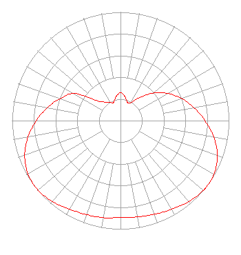 | ||||||||||||||||||
| Azimuth | Ratio | Azimuth | Ratio | Azimuth | Ratio | Azimuth | Ratio | ||||||||||||
| 0 | 0.257 | 10 | 0.227 | 20 | 0.183 | 24 | 0.178 | ||||||||||||
| 30 | 0.194 | 40 | 0.278 | 50 | 0.393 | 60 | 0.502 | ||||||||||||
| 70 | 0.599 | 80 | 0.688 | 90 | 0.778 | 100 | 0.873 | ||||||||||||
| 110 | 0.951 | 120 | 0.993 | 127 | 1.000 | 130 | 0.998 | ||||||||||||
| 140 | 0.976 | 150 | 0.944 | 160 | 0.918 | 170 | 0.901 | ||||||||||||
| 180 | 0.893 | 190 | 0.908 | 200 | 0.921 | 210 | 0.942 | ||||||||||||
| 220 | 0.974 | 230 | 0.995 | 240 | 0.985 | 250 | 0.940 | ||||||||||||
| 260 | 0.865 | 270 | 0.775 | 280 | 0.684 | 290 | 0.593 | ||||||||||||
| 300 | 0.497 | 310 | 0.287 | 320 | 0.222 | 330 | 0.197 | ||||||||||||
| 336 | 0.179 | 340 | 0.184 | 350 | 0.226 | ||||||||||||||
Structure Registration Number 1227719 Structure Type: GTOWER Registered To: American Towers, LLC Structure Address: 759 Friendship Church Road (#303255) Thomasville, GA County Name: Thomas County ASR Issued: 02/07/2020 Date Built: 02/05/2002 Site Elevation: 47.2 m (155 ft.) Structure Height: 570 m (1870 ft.) Height Overall: 608.7 m (1997 ft.) Overall Height AMSL: 655.9 m (2152 ft.) FAA Determination: 08/07/2009 FAA Study #: 2009-ASO-3673-OE Paint & Light FAA Chapters: B, G, H, 3, 10.2, 19.2, 21, 23 PRIOR STUDY 2001-ASW-223-OE 30-40-50.3 N 83-58-20.6 W (NAD 83) 30-40-49.6 N 83-58-21.0 W (Converted to NAD 27) |
1181 Highway 315 Wilkes Barre, PA 18702 Phone: 570-970-5600 Limited Liability Company | Title: Sole Member Date: 02/16/2023 Application Certifier MPS MEDIA OF TALLAHASSEE LICENSE , LLC Mps Media Of Tallahassee License , Llc 1181 Highway 315 Wilkes Barre, PA 18702 Applicant John E. Hidle, PE Carl T. Jones Corporation 7901 Yarnwood Court Springfield, VA 22153-2827 Consulting Engineer Daniel Kirkpatrick Baker Hostetler Llp 1050 Connecticut Ave Nw Suite 1100 Washington, DC 20036 | |||||||||||||||||