
FCCInfo.com
A Service of Cavell, Mertz & Associates, Inc.
(855) FCC-INFO
|
|
|
|
|
||||||||||||||||
|
|
Status: License Application Accepted: 03/20/2023 License Expires: 08/01/2030 File Number: -0000212762 FCC Website Links: LMS Facility Details This Application Other K20KJ-D Applications Including Superseded Applications Mailing Address Correspondence for K20KJ-D Correspondence related to application -0000212762 Service Contour - Open Street Map or USGS Map (51 dBu) Service Contour - KML / Google Earth (51 dBu) Rabbit Ears Info Search for K20KJ-D Site Location: 30-37-58.7 N 96-16-28.2 W (NAD 83) Site Location: 30-37-58.0 N 96-16-27.3 W (Converted to NAD 27) ERP: 15 kW Polarization: Elliptically polarized Electrical Beam Tilt: .50 degrees R/C AGL: 129 m (423 ft.) R/C AMSL: 214 m (702 ft.) Emission Mask: Full Service Site Elevation: 85 m. (279 ft.) Height Overall*: 141.7 m (465 ft.) (* As Filed In This Application, may differ from ASR Data, Below.) Directional Antenna - Antenna Make/Model: Propagation System Inc PSILPOI8-20 Antenna ID: 1010565 Polarization: Elliptically polarized | ||||||||||||||||||
| Antenna Data for Antenna Id: 1010565 K20KJ-D LD File: -0000212762 Propagation System Inc - PSILPOI8-20 Service: LD Standard Pattern: N Pattern and Field Values Include a 205° Clockwise Rotation | 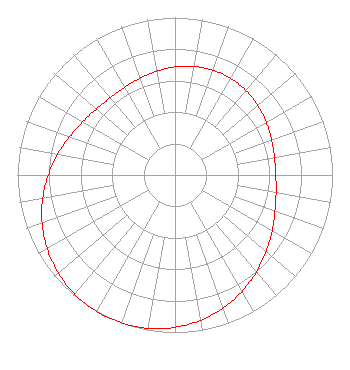 | ||||||||||||||||||
| Azimuth | Ratio | Azimuth | Ratio | Azimuth | Ratio | Azimuth | Ratio | ||||||||||||
| 5 | 0.694 | 15 | 0.705 | 25 | 0.709 | 35 | 0.705 | ||||||||||||
| 45 | 0.694 | 55 | 0.678 | 65 | 0.661 | 75 | 0.646 | ||||||||||||
| 85 | 0.639 | 95 | 0.644 | 105 | 0.662 | 115 | 0.692 | ||||||||||||
| 125 | 0.733 | 135 | 0.780 | 145 | 0.829 | 155 | 0.876 | ||||||||||||
| 165 | 0.918 | 175 | 0.953 | 185 | 0.979 | 195 | 0.995 | ||||||||||||
| 205 | 1.000 | 215 | 0.995 | 225 | 0.979 | 235 | 0.953 | ||||||||||||
| 245 | 0.918 | 255 | 0.876 | 265 | 0.829 | 275 | 0.780 | ||||||||||||
| 285 | 0.733 | 295 | 0.692 | 305 | 0.662 | 315 | 0.644 | ||||||||||||
| 325 | 0.639 | 335 | 0.646 | 345 | 0.661 | 355 | 0.678 | ||||||||||||
Structure Registration Number 1051585 Structure Type: Registered To: American Towers LLC Structure Address: 11060 Nunn Rd (college Station 2 #4338) College Station, TX County Name: Brazos County ASR Issued: 06/23/2016 Date Built: 06/26/1998 Site Elevation: 85 m (279 ft.) Structure Height: 136.8 m (449 ft.) Height Overall: 141.7 m (465 ft.) Overall Height AMSL: 226.7 m (744 ft.) FAA Determination: 07/17/2008 FAA Study #: 2008-ASW-5096-OE FAA Circular #: 70/7460-1J Paint & Light FAA Chapters: 4, 8, 13 OM&L to remain the same as prior study = A MED-DUAL SYSTEM 30-37-58.7 N 96-16-28.2 W (NAD 83) 30-37-58.0 N 96-16-27.3 W (Converted to NAD 27) |
Montgomery, TX 77356 Phone: 936-443-4451 Individual | Title: Manager Date: 03/20/2023 Application Certifier C. DOWEN JOHNSON 104 Woodmont Montgomery, TX 77356 Applicant C. Dowen Johnson Windsong Communications 104 Woodmont Montgomery, TX 77356 Application Certifier JIM MCPHETRIDGE Wes Broadcasting Consultants 104 Woodmont Montgomery, TX 77256 CONSULTING ENGINEER JAMES L. OYSTER Law Offices Of James L. Oyster 108 Oyster Lane Castleton, VA 22716 | |||||||||||||||||